 view gallery view gallery S1.3 km S1.3 km
|   Waterloo Historic District - Warner, NH Waterloo Historic District - Warner, NH
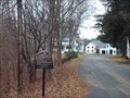
in U.S. National Register of Historic Places Originally known as a mill lot #67, (comprising 60 acres along the
Warner River). Waterloo consists of a grouping of houses and structures of the late 18th and 19th centuries which difine the former village and
its importance to the town of Warner. posted by:  silverquill silverquill location: New Hampshire date approved: 06/19/2007 last visited: never |
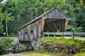
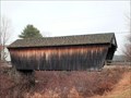
 view gallery view galleryS1.4 km | Waterloo Covered Bridge - Warner, NH in U.S. National Register of Historic Places Built in 1840, in the town lattice truss style, this bridge spans the Warner River, with a length of 76'4" and a clear span of 70'9". It has an overall width of 16'11", a roadway width of 12'11". posted by: silverquill location: New Hampshire date approved: 06/20/2007 last visited: 08/06/2019 |
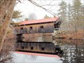 view gallery view galleryS1.4 km |  Waterloo Covered Bridge - Warner, NH Waterloo Covered Bridge - Warner, NH
in Covered Bridges Built in 1840, in the town lattice truss style, this bridge spans the Warner River, with a length of 76'4" and a clear span of 70'9". It has an overall width of 16'11", a roadway width of 12'11". posted by: silverquill location: New Hampshire date approved: 06/21/2007 last visited: never |
 view gallery view gallery SE2.1 km SE2.1 km
|  Dunkin Donuts - Warner NH Dunkin Donuts - Warner NH
in Dunkin Donuts' Located on NH 103 right off I-89 posted by:  nomadwillie nomadwillie location: New Hampshire date approved: 07/04/2015 last visited: 12/28/2020 |
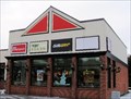 view gallery view gallerySE2.3 km |  Subway - Warner, NH Subway - Warner, NH
in Subway Restaurants A frequent stop for those traveling to and from New Hampshire's Lake Sunapee region for great skiing, boating, and fall foliage viewing, just off I-89 at Exit 9 (NH Route 103) in Warner, New Hampshire. posted by: silverquill location: New Hampshire date approved: 09/30/2007 last visited: never |
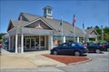
 view gallery view gallerySE2.9 km |  Warner, NH Warner, NH
in City and Town Halls This solid red brick building is the town hall for the community of Warner, New Hampshire, near the scenic Lake Sunapee area of the state. posted by: silverquill location: New Hampshire date approved: 06/27/2011 last visited: never |
 view gallery view gallerySE4.2 km |  Warner, NH 03278 Warner, NH 03278
in U.S. Post Offices This is the new post office for the small town of Warner, New Hampshire. The fall festival here is a great little event. posted by: silverquill location: New Hampshire date approved: 12/31/2007 last visited: never |
 view gallery view gallerySE4.5 km | Dalton Covered Bridge - Warner NH in U.S. National Register of Historic Places The Dalton Covered Bridge, also called the Dalton Bridge, is a historic covered bridge that carries Joppa Road over the Warner River in Warner, New Hampshire. posted by: nomadwillie location: New Hampshire date approved: 08/08/2019 last visited: never |
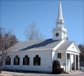
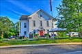
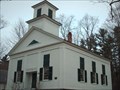 view gallery view gallerySE5.5 km | Lower Warner Meetinghouse - Warner, NH in U.S. National Register of Historic Places The Methodists built a meeting-house at the Lower village somewhere about 1835, and maintained public worship until 1870, since which time it has not been regularly occupied. posted by: silverquill location: New Hampshire date approved: 06/19/2007 last visited: 08/06/2019 |
 view gallery view gallery W6.6 km W6.6 km
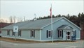
| South Sutton, NH 03273 in U.S. Post Offices Located on NH 114 where it intersects with Meetinghouse Hill Rd posted by: nomadwillie location: New Hampshire date approved: 05/31/2014 last visited: never |
 view gallery view galleryW6.8 km | South Sutton Meeting House - South Sutton NH in U.S. National Register of Historic Places The South Sutton Meeting House was constructed in 1839, and is a well-preserved example of rural vernacular Greek Revival architecture. posted by: nomadwillie location: New Hampshire date approved: 08/08/2019 last visited: never |
 view gallery view gallery SW7.1 km SW7.1 km
|  Bradford, NH Bradford, NH
in Artistic Welcome Signs The small community of Bradford, once a thriving mill town, may have other competitors for this title, but is a short distance from the scenic Lake Sunapee and the Mount Sunapee ski area, nestled in the picturesque mountains of central New Hampshire. posted by: silverquill location: New Hampshire date approved: 05/31/2011 last visited: never |
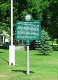 view gallery view galleryW7.6 km |  John Sargent Pillsbury - Sutton NH John Sargent Pillsbury - Sutton NH
in New Hampshire Historical Markers Located on the common in South Sutton at the junction of NH 114 and Meetinghouse Hill Road. posted by: nomadwillie location: New Hampshire date approved: 10/03/2009 last visited: 04/09/2010 |
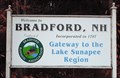
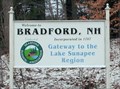 view gallery view gallerySW8.2 km |  Gateway to the Lake Sunapee Region - Bradford, NH Gateway to the Lake Sunapee Region - Bradford, NH
in Welcome Signs The small community of Bradford, once a thriving mill town, may have other competitors for this title, but is a short distance from the scenic Lake Sunapee and the Mount Sunapee ski area, nestled in the picturesque mountains of central New Hampshire. posted by: silverquill location: New Hampshire date approved: 11/10/2009 last visited: never |
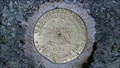 view gallery view gallerySW8.4 km |  MAC 73 1925 (USGS, Bradford, NH) MAC 73 1925 (USGS, Bradford, NH)
in U.S. Benchmarks A USGS standard bench mark disk, located at Lake Massasecum, in Bradford, NH.
The NHDOT ID# is 53-0040. posted by: NH2beers location: New Hampshire date approved: 10/03/2011 last visited: never |
 view gallery view gallery NW8.7 km NW8.7 km
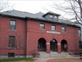
| Pillsbury Memorial Hall - Sutton NH in U.S. National Register of Historic Places Pillsbury Memorial Hall was built in 1891, funded by a gift from New Hampshire native John Sargent Pillsbury, founder of the Pillsbury Company and a leading Minnesota politician. posted by: nomadwillie location: New Hampshire date approved: 08/08/2019 last visited: never |
 view gallery view gallerySW8.7 km | Bradford, NH 03221 in U.S. Post Offices This is the post office for the community of Bradford, New Hampshire, in the Lake Sunapee region of the state. posted by: silverquill location: New Hampshire date approved: 12/31/2007 last visited: never |
 view gallery view gallerySW8.9 km | Bement Covered Bridge - Bradford, NH in U.S. National Register of Historic Places Bement Covered Bridge, spanning the west branch of the Warner River, was built in 1854 at a cost of $500. Long truss system. The bridge is 60'6" long with a clear span of 53'9". It has an overall width of 19'3" with a roadway width of 16'2". posted by: silverquill location: New Hampshire date approved: 06/20/2007 last visited: 07/17/2007 |
 view gallery view gallerySW8.9 km | Bement Covered Bridge - Bradford, NH in Covered Bridges Bement Covered Bridge, spanning the west branch of the Warner River, was built in 1854 at a cost of $500. Long truss system. The bridge is 60'6" long with a clear span of 53'9". It has an overall width of 19'3" with a roadway width of 16'2". posted by: silverquill location: New Hampshire date approved: 06/21/2007 last visited: 07/06/2013 |
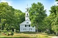
 view gallery view gallerySW9.2 km |  First Baptist Church Clock - Bradford, NH First Baptist Church Clock - Bradford, NH
in Town Clocks A traditional New England church in Bradford, NH. posted by: silverquill location: New Hampshire date approved: 04/26/2007 last visited: never |
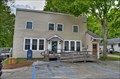
 view gallery view gallerySW9.2 km |  St Peter's Lodge #31 - Bradford NH St Peter's Lodge #31 - Bradford NH
in Masonic Temples Located on 89 West Main St. posted by: nomadwillie location: New Hampshire date approved: 12/21/2013 last visited: never |
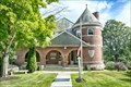
 view gallery view galleryW9.2 km |  Brown Memorial Library - Bradford NH Brown Memorial Library - Bradford NH
in Libraries Located at 78 West Main St. posted by: nomadwillie location: New Hampshire date approved: 12/21/2013 last visited: never |
 view gallery view gallerySW9.2 km | Bradford, NH in City and Town Halls Built in 1863 from timbers of the dismantled Town Meeting House that was built in 1797 posted by: nomadwillie location: New Hampshire date approved: 12/20/2013 last visited: never |
 view gallery view gallerySW9.2 km | Bradford Town Hall - Bradford NH in U.S. National Register of Historic Places Built in 1863 it is based on the Meeting House that it replaced and includes a lot of the timbers from that building. posted by: nomadwillie location: New Hampshire date approved: 12/19/2013 last visited: never |
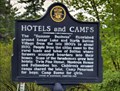 view gallery view galleryNW9.8 km | Hotels and Camps - North Sutton NH in New Hampshire Historical Markers Located right where NH 114 bends around the Baptist Freewill Church and General Store. posted by: nomadwillie location: New Hampshire date approved: 05/29/2014 last visited: 07/26/2017 |
|