
Bradford, NH
Posted by:  silverquill
N 43° 16.046 W 071° 55.750
19T E 262280 N 4794680
The small community of Bradford, once a thriving mill town, may have other competitors for this title, but is a short distance from the scenic Lake Sunapee and the Mount Sunapee ski area, nestled in the picturesque mountains of central New Hampshire.
Waymark Code: WMBJK9
Location: New Hampshire, United States
Date Posted: 05/27/2011
Views: 6

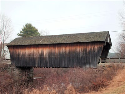
BEMENT COVERED BRIDGE
BRADFORD, NEW HAMPSHIRE
Typical of this part of New Hampshire, there are a number of old covered bridges left. This welcome sign depicts the nearby Bement Bridge.
There isn't a season when Lake Sunapeee doesn't sparkle. In the winter there is ice fishing and and overlooking the lake is the popular Mt. Sunapee ski area. Fall foliage is renowned, of course, with the brilliant colors giving the backdrop of Sunapee's blue waters a special brilliance. There are numerous resorts, private homes, campgrounds and places of public access, making this a popular tourist destination. There are several types of sight seeing boat tours, including sunset dinner cruises on the old boats.
From the
Lake Sunapee Living web site:
"Lake Sunapee is ten miles long and is the highest lake of its size in America, 1100 Ft. above sea level.There are only a handful of public access places with swimming and boat launch ramps on the lake. As you drive up from the south on 103 through Bradford into Newbury you will first see the Lake Sunapee from Newbury Harbor, A spectacular view that looks out through The Narrows on miles of open water with Great Island and Burkehaven Lighthouse just barely visible on a clear day."
From the Wikipedia: Bradford, New Hampshire
"Granted by Governor Benning Wentworth in 1765 to John Pierce and George Jaffrey of Portsmouth, it was settled in 1771 by Dea. William Presbury and family. Three years later other settlers arrived, several of them from Bradford, Massachusetts, after which the town was named New Bradford. Later, it was called Bradfordton, but upon incorporation by the General Court on September 27, 1787, it was officially named Bradford."
"Parts of the town are hilly, but the largest portion is in a valley with varied soil. Streams provided water power for watermills. By 1859, when Bradford's population reached 1,341, industries included one woolen mill, one sash, blind and door factory, one wheelwright shop, two sawmills, one gristmill, one tannery, and one clothing mill. In 1850, the Concord & Claremont Railroad opened from Concord to Bradford, which would remain its terminus until the line was extended to Claremont in 1871-1872."