 view gallery view gallery S10.3 km S10.3 km
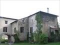
|   Chateau de Foix, France Chateau de Foix, France
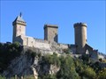
in Castles Chateau de Foix, the castle of the Counts de Foix was a key center of resistance by the Counts de Foix and the Cathars against the Albigensian Crusade. The three towers are distinctive landmarks. posted by:  arby101ca arby101ca location: France date approved: 05/03/2010 last visited: 01/08/2020 |
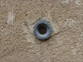
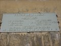
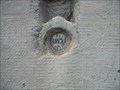
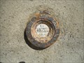
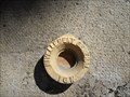
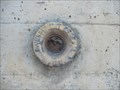
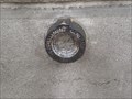 view gallery view galleryS10.3 km |  Benchmarck de l'agence de Foix Benchmarck de l'agence de Foix
in French Benchmarks Repère de nivellement de l'Ariège posted by:  yohaeva yohaeva location: Occitanie, France date approved: 08/28/2014 last visited: 01/08/2020 |
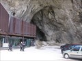
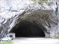 view gallery view galleryS20.9 km | ") La grotte de Bédeilhac (Ariège) - France La grotte de Bédeilhac (Ariège) - France
in Cave Entrances (Natural) [FR] La grotte de Bédeilhac est une vaste grotte ornée située sur la commune de Bédeilhac-et-Aynat en Ariège. [EN] The caves of the Ariège have some of the finest examples of paleolithic paintings and artifacts anywhere in the world. posted by: RakeInTheCache location: Occitanie, France date approved: 05/26/2012 last visited: 02/06/2020 |
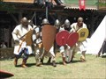 view gallery view gallery E21.7 km E21.7 km
|  Fêtes historiques : Les Médiévales de Mirepoix - Ariège, Occitanie, France Fêtes historiques : Les Médiévales de Mirepoix - Ariège, Occitanie, France
in Renaissance Fairs [FR] Les Médiévales de Mirepoix se déroulent chaque année le 3ème week-end de juillet.
[EN] The Medieval of Mirepoix take place every year on the 3rd weekend of July. posted by: Waldog location: Occitanie, France date approved: 11/15/2018 last visited: 02/29/2020 |
 view gallery view galleryS22.7 km |  Domaine Fournié - Tarascon-sur-Ariège, France Domaine Fournié - Tarascon-sur-Ariège, France
in Bed and Breakfast [FR] La famille Marie vous ouvre les portes de sa propriété du 17e siecle, au parc centenaire et bois classé. [EN] The Marie family welcomes you to their 17th century property, where you can unwind in the shade of the hundred year old trees. posted by: RakeInTheCache location: Occitanie, France date approved: 05/20/2012 last visited: 02/06/2020 |
 view gallery view galleryS26.6 km | La grotte de Niaux (Ariège) - France in Cave Entrances (Natural) [FR] La grotte de Niaux est une grotte ornée du Paléolithique supérieur ayant livré de nombreuses figurations pariétales magdaléniennes. [EN] Like Lascaux, La grotte de Niaux, contains many prehistoric paintings of superior quality. posted by: RakeInTheCache location: Occitanie, France date approved: 05/26/2012 last visited: 02/06/2020 |
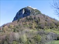 view gallery view gallery SE27.2 km SE27.2 km
| Montségur, France in Castles The Montségur fortress was the last holdout of the Cathars. It fell in 1244 and the remaining Cathars were burned, martyred for their faith. posted by: arby101ca location: France date approved: 05/03/2010 last visited: 01/27/2020 |
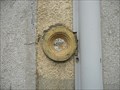
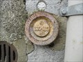
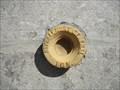
 view gallery view galleryS29.6 km | Benchmarck église d'Arquizat in French Benchmarks Repère de nivellement en Ariège posted by: yohaeva location: Occitanie, France date approved: 08/28/2014 last visited: 02/06/2020 |
 view gallery view gallery NE36.7 km NE36.7 km
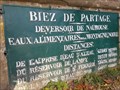
|  Seuil de Naurouze, Montferrand, France Seuil de Naurouze, Montferrand, France
in Watershed Markers and Monuments [FR] Le seuil de Naurouze, à Montferrand marque le partage des eaux des bassins méditerranéen et atlantique
[EN] The threshold of Naurouze, in Montferrand marks the watershed of the Mediterranean and Atlantic basins posted by: junkys location: Occitanie, France date approved: 12/29/2017 last visited: never |
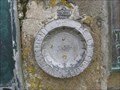 view gallery view galleryNE36.7 km | NGF, Naurouze, Z'.E.Q3 - 17 (Canal du Midi - Partage des eaux) in French Benchmarks [FR] Paul Riquet fut le premier à découvrir ce site sur le seuil de partage des eaux. [EN] The Seuil de Naurouze is the watershed point identified by Pierre-Paul Riquet when he designed and built the Canal du Midi. posted by: RakeInTheCache location: Occitanie, France date approved: 05/05/2012 last visited: 03/22/2018 |
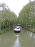 view gallery view galleryNE37.2 km |  Canal du Midi (Ecluse de l'Océan), France Canal du Midi (Ecluse de l'Océan), France
in World Heritage Sites [FR] Le canal du Midi est un canal français qui relie la Garonne à la mer Méditerranée. [EN] The Canal du Midi is a 240 km (150 mi) long canal in Southern France. posted by: RakeInTheCache location: Occitanie, France date approved: 05/16/2012 last visited: never |
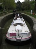 view gallery view galleryNE37.2 km |  L'écluse de l'Océan (Le Canal du Midi) - France L'écluse de l'Océan (Le Canal du Midi) - France
in Waterway Locks, Planes and Lifts [FR] L'écluse de l'Océan est une écluse à chambre unique sur le canal du Midi. [EN] Océan Lock is a single chamber lock on the Canal du Midi. posted by: RakeInTheCache location: Occitanie, France date approved: 05/19/2012 last visited: never |
 view gallery view galleryNE37.2 km |  Ecluse de l'Océan (Canal du Midi) - France Ecluse de l'Océan (Canal du Midi) - France
in Elevation Signs [FR] Le seuil de Naurouze est un seuil géographique (ou col) de 189 mètres d’altitude. [EN] The Seuil de Naurouze, aka Col de Naurouze, is a mountain pass in southern France. posted by: RakeInTheCache location: Occitanie, France date approved: 05/16/2012 last visited: never |
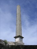 view gallery view galleryNE37.2 km |  L'obélisque de Riquet (Midi-Pyrénées) - France L'obélisque de Riquet (Midi-Pyrénées) - France
in Obelisks [FR] En 1825, les héritiers de Riquet font ériger un obélisque au seuil de Naurouze pour marquer la symbolique du lieu. [EN] The Riquet Obelisk is dedicated to the creater of the Canal du Midi, Pierre-Paul Riquet. posted by: RakeInTheCache location: Occitanie, France date approved: 05/16/2012 last visited: 03/22/2018 |
 view gallery view gallery W37.5 km W37.5 km
| Benchmark E.C.O3P3 - 9 - Eycheil in French Benchmarks Localisation : AU NO 16, ROUTE DES PYRENEES
Partie support : MUR DE FACADE SUD-OUEST DE LA PARTIE CENTRALE, FACE ROUTE
Altitude : 408,025 m posted by: eolas location: Occitanie, France date approved: 02/21/2013 last visited: never |
 view gallery view galleryW37.8 km | Benchmark E.C.O3P3 - 7 - Saint-Girons in French Benchmarks Localisation : A LA PLAINE D'EYCHEIL, AU NO 72, AVENUE DE LA RESISTANCE
Altitude : 405,245 m posted by: eolas location: Occitanie, France date approved: 02/21/2013 last visited: never |
 view gallery view gallery NW37.8 km NW37.8 km
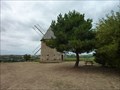
|  Le moulin de pesquies Le moulin de pesquies
in Windmills Le moulin à vent de Pesquies.
Restauré en 1991, il ne fonctionne plus. posted by: niko_kristyn location: Occitanie, France date approved: 07/31/2017 last visited: never |
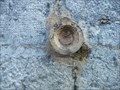
 view gallery view galleryW38 km | Benchmark E.C.O3P3 - 6 - D.618 - Saint-Girons in French Benchmarks Type : Repère cylindrique
Localisation : Plaine d'Eycheil, 61 Avenue de la Résitance
Partie support : Soubassement du mur pignon sud-ouest, face route
Altitude : 403.25 posted by: eolas location: Occitanie, France date approved: 02/20/2013 last visited: never |
 view gallery view galleryW38.3 km | Benchmark - ANCIEN COLLEGE D'ENSEIGNEMENT TECHNIQUE in French Benchmarks Localisation : A SAINT-GIRONS, AU NO 28 DE L'AVENUE RENE PLAISANT
Support : MAISON (ANCIEN COLLEGE D'ENSEIGNEMENT TECHNIQUE)
Altitude : 390,435 m posted by: eolas location: Occitanie, France date approved: 02/21/2013 last visited: never |
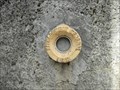
 view gallery view galleryW38.5 km | Benchmark E.C.P3 - 3 - D.117 - Saint-Girons in French Benchmarks Type : repère cylindrique nivellement
Localisation : pont D117
Altitude : 391.45 posted by: eolas location: Occitanie, France date approved: 02/20/2013 last visited: never |
 view gallery view galleryW38.6 km | Benchmark E.C.O3P3 - 2 - Saint-Girons in French Benchmarks Localisation : AU CARREFOUR AVEC LE BOULEVARD PEYREVIDOL
Partie support : MUR DE FACADE SUD-OUEST, FACE RUE DESBIAUX
Altitude : 392,194 m posted by: eolas location: Occitanie, France date approved: 02/20/2013 last visited: never |
 view gallery view galleryW38.6 km | Benchmark E.C.O3P3 - 1 - Saint-Girons in French Benchmarks Support : ECOLE PAUL SAINT-ALARY
Partie support : SOUBASSEMENT DU MUR DE FACADE SUD-OUEST, FACE PLACE
Altitude : 391,825 m posted by: eolas location: Occitanie, France date approved: 02/20/2013 last visited: never |
 view gallery view galleryW38.6 km | Benchmark L'église de Saint-Girons in French Benchmarks Localisation : A 190 M AU SUD DU CARREFOUR DE LA D.117 ET DE LA RUE DU MARCHE, PLACE DE VERDUN
Partie support : ABOUT DU 2EME CONTREFORT DU TRANSEPT GAUCHE A PARTIR DU CHOEUR, FACE A LA
PLACE, FACE NORD-OUEST
Altitude: 390.818 m. posted by: eolas location: Occitanie, France date approved: 02/20/2013 last visited: never |
 view gallery view galleryW38.8 km | Benchmark Pont neuf - Saint-Girons in French Benchmarks Localisation : A L'ANGLE SUD-OUEST DU SQUARE BALAGUE
Support : PONT SUR LE SALAT
Altitude : 390,329 m posted by: eolas location: Occitanie, France date approved: 02/21/2013 last visited: never |
 view gallery view galleryW38.8 km | Benchmark E.C.O3P3 - 4 - D.618 - Saint-Girons in French Benchmarks Type : Repère cylindrique de nivellement
Localisation : à 15 mètres au sud-est du carrefour avec la rue Morinière
Altitude : 398.94 posted by: eolas location: Occitanie, France date approved: 02/20/2013 last visited: never |
|