 view gallery view gallery S11.4 km S11.4 km
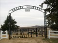
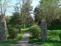
|   Valley Cemetery, Verdel, Nebraska Valley Cemetery, Verdel, Nebraska
in Worldwide Cemeteries Also known as Ponca Valley Cemetery.
Elevation 1327 posted by:  NGComets NGComets location: Nebraska date approved: 12/13/2017 last visited: never |
 view gallery view gallery NE13 km NE13 km
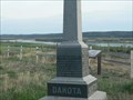
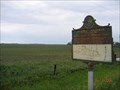
|  Historic Highway >-----> 11.5 Miles S of Avon Historic Highway >-----> 11.5 Miles S of Avon
in South Dakota Historical Markers Missouri River Historic Highway 11.5 miles S of Avon with Running Water, Springfield, old Ft. Mitchell, and Niobrara, NE nearby. posted by: plainsdrifter358 location: South Dakota date approved: 07/07/2006 last visited: 06/11/2006 |
 view gallery view galleryNE13 km | Avon, SD Birthplace of Senator George McGovern in South Dakota Historical Markers Avon, SD: Birthplace of Senator and US Presidential Candidate George McGovern. posted by: plainsdrifter358 location: South Dakota date approved: 07/07/2006 last visited: 06/11/2006 |
 view gallery view gallery SE15.3 km SE15.3 km
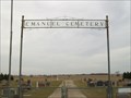
| Emanuel Cemetery, Springfield, South Dakota in Worldwide Cemeteries In Bon Homme County, South Dakota, about 5 miles west of Springfield.
Elevation 1476. posted by: NGComets location: South Dakota date approved: 12/13/2017 last visited: never |
 view gallery view gallery SW17.4 km SW17.4 km
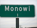
|  Monowi, Nebraska - Population 1 Monowi, Nebraska - Population 1
in Population Signs A very small town along Highway 12 in northern Nebraska. Elevation 1354. posted by: NGComets location: Nebraska date approved: 12/17/2017 last visited: never |
 view gallery view gallery W18.8 km W18.8 km
| Yankton Dakota Sioux Treaty of 1858 in South Dakota Historical Markers Yankton Dakota Sioux Tribe Treaty of 1858 posted by: plainsdrifter358 location: South Dakota date approved: 05/20/2006 last visited: 05/21/2006 |
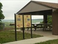
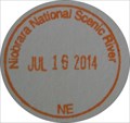 view gallery view galleryS18.8 km |  Niobrara National Scenic River - Niobrara State Park Niobrara National Scenic River - Niobrara State Park
in NPS Passport Cancellation Stations Nebraska's Niobrara State Park visitor center has the NPS Passport cancellations for Niobrara NSR and Missouri NRR, as the park adjoins the confluence of the two rivers. posted by: The WBs location: Nebraska date approved: 07/22/2014 last visited: 07/16/2014 |
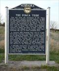 view gallery view galleryS19.2 km |  Ponca Indians Ponca Indians
in Nebraska Historical Markers The marker relates history of the Poncas and the tribe's most famous member, Chief Standing Bear. posted by:  NevaP NevaP location: Nebraska date approved: 05/11/2008 last visited: never |
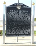 view gallery view gallerySE20.3 km | The Sage Brothers in Nebraska Historical Markers The marker, in Niobrara Nebraska, honors three brothers who were casualties of the VietNam War. posted by: NevaP location: Nebraska date approved: 05/11/2008 last visited: never |
 view gallery view gallery E21.4 km E21.4 km
| Historic Highway -------->S through Springfield Bon Homme was 7 in South Dakota Historical Markers historic highway posted by: MNSearchers location: South Dakota date approved: 06/29/2006 last visited: 08/08/2007 |
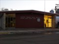
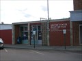
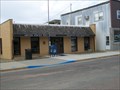 view gallery view galleryE21.7 km |  Springfield, South Dakota 57062 Springfield, South Dakota 57062
in U.S. Post Offices Small town post office.
Elevation 1307 posted by: NGComets location: South Dakota date approved: 04/13/2013 last visited: never |
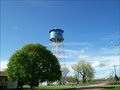
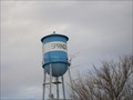 view gallery view galleryE21.9 km |  Watertower - Springfield, South Dakota Watertower - Springfield, South Dakota
in Water Towers Elevation 1286.
Old watertower in the central part of town. posted by: NGComets location: South Dakota date approved: 04/09/2013 last visited: never |
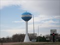 view gallery view galleryE21.9 km | New Watertower - Springfield, South Dakota in Water Towers New watertower installed in the north part of town in 2005.
Elevation 1227 posted by: NGComets location: South Dakota date approved: 04/09/2013 last visited: 08/11/2014 |
 view gallery view gallery NW22 km NW22 km
| Wagner, South Dakota 57380 in U.S. Post Offices Small town post office.
elevation 1454 posted by: NGComets location: South Dakota date approved: 03/24/2013 last visited: never |
 view gallery view galleryE22.2 km | Lewis & Clark at Springfield, SD in South Dakota Historical Markers Lewis & Clark were in South Dakota from 21 August 1804 to 14 October 1804 and again from 21 August 1806 to 4 September 1806. The Corp of Discover camped on Bon Homme Island on 1 September 1804 and again on 1 September 1806. posted by: plainsdrifter358 location: South Dakota date approved: 07/07/2006 last visited: 06/16/2006 |
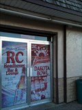 view gallery view galleryNW22.4 km |  Dakota Bowl, Wagner, South Dakota Dakota Bowl, Wagner, South Dakota
in Bowling Centres 107 North Main, Wagner, SD.
Elevation 1424 posted by: NGComets location: South Dakota date approved: 04/08/2013 last visited: never |
 view gallery view galleryNW24.1 km | Martin Marty & Rev Sylvester Eisenman in South Dakota Historical Markers "Martin Marty & Rev Sylvester Eisenman" HM in Marty, SD posted by: plainsdrifter358 location: South Dakota date approved: 04/30/2006 last visited: 04/30/2006 |
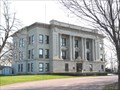 view gallery view galleryE25.1 km |  Bon Homme County Courthouse, Tyndall, SD Bon Homme County Courthouse, Tyndall, SD
in U.S. National Register of Historic Places Bon Homme County's second courthouse was constructed in 1914. posted by: NevaP location: South Dakota date approved: 05/12/2008 last visited: 02/15/2023 |
 view gallery view galleryE25.1 km |  Bon Homme County Courthouse, Tyndall, SD Bon Homme County Courthouse, Tyndall, SD
in Courthouses This beautiful Beaux Arts Style courthouse was built in 1914. posted by: NevaP location: South Dakota date approved: 05/12/2008 last visited: 02/15/2023 |
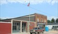
 view gallery view galleryE25.3 km | Tyndall, South Dakota 57066 in U.S. Post Offices Small town post office in the County Seat. posted by: NGComets location: South Dakota date approved: 06/15/2012 last visited: 02/15/2023 |
 view gallery view galleryE25.3 km |  Tyndall, SD USA Tyndall, SD USA
in Wikipedia Entries The small town of Tyndall, seat of Bon Homme county SD, has its own Wikipedia article. posted by: Benchmark Blasterz location: South Dakota date approved: 02/15/2023 last visited: 02/16/2023 |
 view gallery view galleryNE25.4 km | Watertower, Tyndall, South Dakota in Water Towers Small town watertower. Nicely decorated and constructed in the mid 30's to supply water for the town. posted by: NGComets location: South Dakota date approved: 06/14/2012 last visited: 02/15/2023 |
 view gallery view galleryW27.2 km | Lynch, Nebraska 68746 in U.S. Post Offices Small town along NE Highway 20.
Elevation 1397 posted by: NGComets location: Nebraska date approved: 12/11/2017 last visited: never |
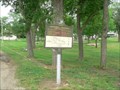
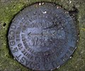 view gallery view galleryE31.7 km |  NM1890 Reference Mark No. 2 NM1890 Reference Mark No. 2
in U.S. Benchmarks NM1890 RM #2. DESIGNATION - MONUMENT .......STATION, RM1 & AZ WERE NOT FOUND AT THIS TIME. posted by: Blaise Orange location: South Dakota date approved: 06/22/2009 last visited: never |
 view gallery view galleryNW32.5 km | Fort Randall Casino Water Tower in Water Towers This water tower is at the Fort Randall Casino & Hotel. posted by: PeterNoG location: South Dakota date approved: 06/06/2011 last visited: 08/30/2012 |
|