 view gallery view gallery W0.2 km W0.2 km
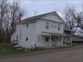
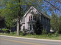
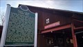
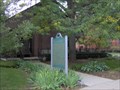
|   Lakeville Auxiliary Hall Lakeville Auxiliary Hall
in Michigan Historical Markers Located on the west side of Milmine Road between Rochester Road and Rochester Road (no, I'm not kidding, it's 'L' shaped here). Streetside parking available.
posted by:  S5280ft S5280ft location: Michigan date approved: 12/03/2006 last visited: 01/06/2014 |
 view gallery view gallery SW1.1 km SW1.1 km
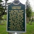
| Lakeville Cemetery in Michigan Historical Markers Lakeville Cemetery is located on Drahner Road in between Rochester Road and Lake George Road. You can park on the road entering the cemetery, not a busy area. posted by:  The D Zone The D Zone location: Michigan date approved: 05/11/2013 last visited: 01/06/2014 |
 view gallery view gallery S4 km S4 km
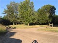
| Axford-Coffin Farm in Michigan Historical Markers Now part of the Oakland Township park system. Located on the north side of Predmore Road, approximately 1/2 mile west of Rochester Road. posted by: S5280ft location: Michigan date approved: 12/03/2006 last visited: 01/06/2014 |
 view gallery view gallerySW8.4 km | Carpenter-Rudd Mills in Michigan Historical Markers Site of one of the first sawmills in Orion Township. posted by: Ikenspike location: Michigan date approved: 09/23/2006 last visited: 02/26/2019 |
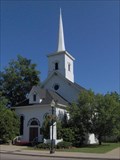 view gallery view gallerySW8.5 km | Lake Orion Methodist Church in Michigan Historical Markers On the south side of East Flint Street between South Slateer and South Anderson Streets. posted by: S5280ft location: Michigan date approved: 06/04/2006 last visited: 01/06/2014 |
 view gallery view gallerySW8.5 km | Predmore House in Michigan Historical Markers At the southeast corner of East Church and Broadway Streets. The marker is facing Broadway. Look behind the pine tree. Currently undergoing restoration. Nearest parking at the church on the north side of East Church Road. posted by: S5280ft location: Michigan date approved: 06/04/2006 last visited: 01/06/2014 |
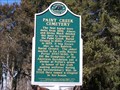 view gallery view galleryS8.7 km | Paint Creek Cemetery in Michigan Historical Markers Nice little cemetery off of Orion Road, there is parking available in front of the marker. posted by: The D Zone location: Michigan date approved: 03/12/2012 last visited: 01/06/2014 |
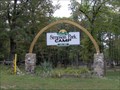 view gallery view gallery E8.9 km E8.9 km
| Simpson Park Campground in Michigan Historical Markers On the west side of Camp Ground Road between West Gates Road (32 1/2 Mile) and 33 Mile Roads. Parking available inside the campground. posted by: S5280ft location: Michigan date approved: 09/17/2006 last visited: 10/20/2017 |
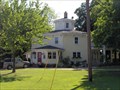
 view gallery view gallery NW8.9 km NW8.9 km
| Harry Frink House in Michigan Historical Markers On the south side of an east-west jog in Oxford Road (Noble Road). Between Gardner and Cobblestone Roads. No parking except along the road. posted by: S5280ft location: Michigan date approved: 06/04/2006 last visited: 01/06/2014 |
 view gallery view galleryNW8.9 km |  Harry Frink House (Octagon Category) Harry Frink House (Octagon Category)
in Octagon Buildings On the south side of an east-west jog in Oxford Road (Noble Road). Between Gardner and Cobblestone Roads. No parking except along the road. posted by: S5280ft location: Michigan date approved: 08/26/2006 last visited: 03/11/2012 |
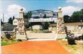 view gallery view gallerySW9.2 km |  Orion Veterans Memorial Orion Veterans Memorial
in Non-Specific Veteran Memorials A memorial dedicated to all who admirably served our country. posted by: Ikenspike location: Michigan date approved: 10/10/2006 last visited: 03/11/2012 |
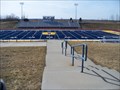 view gallery view galleryW9.5 km |  Oxford Football Oxford Football
in Illuminated School Sports Fields Oxford Wildcats water tower on the east and Oxford's Navy Blue field turf to west. posted by: The D Zone location: Michigan date approved: 03/22/2012 last visited: 03/17/2012 |
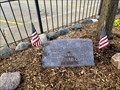 view gallery view galleryW9.7 km |  Vietnam War Memorial - Centennial Park - Oxford, MI USA Vietnam War Memorial - Centennial Park - Oxford, MI USA
in Vietnam War Memorials This Vietnam War memorial is located in Centennial Park at 41 South Washington Avenue, Oxford MI 48371, United States of America posted by: bobfrapples8 location: Michigan date approved: 01/17/2022 last visited: never |
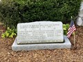 view gallery view galleryW9.7 km |  Oxford World War II Memorial - Oxford, MI Oxford World War II Memorial - Oxford, MI
in World War II Memorials / Monuments This World War II memorial is located in Centennial Park at 41 South Washington Avenue, Oxford MI 48371, United States of America posted by: bobfrapples8 location: Michigan date approved: 01/16/2022 last visited: never |
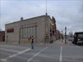 view gallery view galleryW9.7 km | Oxford Savings Bank in Michigan Historical Markers Located on the northwest corner of Burdick and Washington Roads in Oxford. There is a parking lot west of the bank building. posted by: S5280ft location: Michigan date approved: 12/03/2006 last visited: 11/29/2021 |
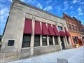 view gallery view galleryW9.7 km |  Oxford Savings Bank - Oxford, MI USA Oxford Savings Bank - Oxford, MI USA
in Converted Bank Buildings Former bank is now the Oxford Village Historical Society. posted by: bobfrapples8 location: Michigan date approved: 12/13/2021 last visited: never |
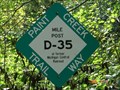 view gallery view galleryS9.8 km |  Paint Creek Trail: Gallagher Rd Trailhead Paint Creek Trail: Gallagher Rd Trailhead
in Rails to Trails The Gallagher Rd trailhead has plenty of parking and a comfort station. posted by: moochie location: Michigan date approved: 09/12/2006 last visited: 07/08/2010 |
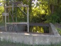 view gallery view galleryS9.8 km | Paint Creek Mill Race in Michigan Historical Markers At the northwest corner of Orion and Gallagher Roads. Parking is available to the south at the Mill on Orion Road posted by: S5280ft location: Michigan date approved: 06/24/2006 last visited: 01/06/2014 |
 view gallery view galleryS10 km | Paint Creek Cider Mill in Michigan Historical Markers 4480 Orion Rd
Oakland Township, Oakland County posted by: Historic Markers location: Michigan date approved: 05/30/2020 last visited: 02/16/2020 |
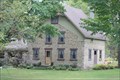 view gallery view galleryS10 km |  Stone House, Oakland Township, Michigan Stone House, Oakland Township, Michigan
in Cobblestone Buildings This house has been here for a long time. It is a private residence. posted by: SafeRad location: Michigan date approved: 10/03/2010 last visited: 04/01/2012 |
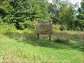
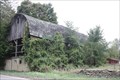 view gallery view galleryS10.1 km |  Oakland Township Barn, Snell Road Oakland Township Barn, Snell Road
in Barns Old unused barn next to the road.
NOTE: 1/1/2013 I heard that the barn was torn down. So if you can't find it, it's probably true. posted by: SafeRad location: Michigan date approved: 10/08/2010 last visited: 04/01/2012 |
 view gallery view gallerySW10.3 km | Decker Settlement/Jesse Decker in Michigan Historical Markers On the south side of Greenshield Road 1.5 miles east of Lapeer Road, at the Bald Mountain Recreation Area Park Headquarters. Parking available across the street. posted by: S5280ft location: Michigan date approved: 06/24/2006 last visited: 01/06/2014 |
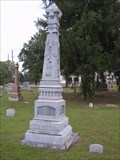 view gallery view galleryE10.5 km |  Streeter Zinc Headstone - McCafferty Cemetery - Romeo, MI Streeter Zinc Headstone - McCafferty Cemetery - Romeo, MI
in Zinc Headstones Located on the west side of Van Dyke just north of 34 Mile Road. posted by: Team--B location: Michigan date approved: 08/21/2010 last visited: 12/07/2013 |
 view gallery view galleryE10.9 km | Village of Romeo in Michigan Historical Markers In front of the Romeo District Library (Kezar Branch) on the west side of North Main Street, between Newberry Road and Church Streets. Parking available at the Library. posted by: S5280ft location: Michigan date approved: 09/17/2006 last visited: 01/06/2014 |
 view gallery view gallerySW11.4 km |  South Unit Trails - Bald Mountain Recreation Area - Lake Orion, MI South Unit Trails - Bald Mountain Recreation Area - Lake Orion, MI
in Mountain Bike Trailheads 4.8 mile loop with rolling hills, a few steep ones posted by: Dinoprophet location: Michigan date approved: 09/20/2008 last visited: 04/26/2009 |
|