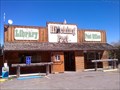
 view gallery view gallery SE0 km SE0 km
|   Sprague River, OR 97639 Sprague River, OR 97639
in U.S. Post Offices This post office is part of a larger complex containing a trading post and library in Sprague River, OR. posted by:  NW_history_buff NW_history_buff location: Oregon date approved: 11/21/2013 last visited: 10/04/2015 |
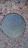
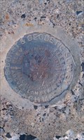 view gallery view gallery N0.2 km N0.2 km
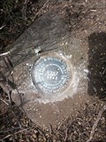
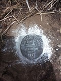
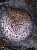
|  NY0567 - USC&GS 'P 352' - Sprague River, OR NY0567 - USC&GS 'P 352' - Sprague River, OR
in U.S. Benchmarks This NGS benchmark is monumented at the top of a concrete staircase of the former Sprague River High School which burned down in the 1960s and only the concrete foundation remains in Sprague River, OR. posted by: NW_history_buff location: Oregon date approved: 02/20/2013 last visited: never |
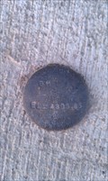 view gallery view galleryN0.8 km | Sprague River Bridge 4305.86 - Sprague River, OR in U.S. Benchmarks This benchmark exists at the newer constructed Sprague River Bridge in Sprague River, OR. posted by: NW_history_buff location: Oregon date approved: 06/05/2012 last visited: never |
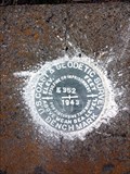 view gallery view gallery NW5.1 km NW5.1 km
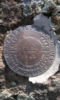
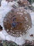
| NY0563 - USC&GS 'K 352' BM - Klamath County, OR in U.S. Benchmarks This NGS benchmark is located along Sprague River Road. posted by: NW_history_buff location: Oregon date approved: 06/17/2016 last visited: never |
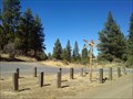 view gallery view gallery SW5.8 km SW5.8 km
|  OC&E Woods Line State Trailhead - Bliss Road Access - Klamath County, OR OC&E Woods Line State Trailhead - Bliss Road Access - Klamath County, OR
in Rails to Trails This rails-to-trails trailhead access point is located just off Bliss Road in Klamath County, OR. posted by: NW_history_buff location: Oregon date approved: 11/17/2013 last visited: 10/04/2015 |
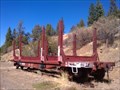 view gallery view gallerySW6 km |  Log Hauler at OC&E Woodsline State Trailhead - Klamath County, OR Log Hauler at OC&E Woodsline State Trailhead - Klamath County, OR
in Static Train Cars This log hauler static display is located next to the OC&E Woodsline State Trailhead just off Bliss Road in Klamath County, OR. posted by: NW_history_buff location: Oregon date approved: 09/09/2013 last visited: 10/04/2015 |
 view gallery view gallerySW7.1 km | NY0379 - USC&GS 'J 350' BM - Klamath County, OR in U.S. Benchmarks This NGS benchmark is located off an abandoned dirt road NW from Bliss Rd in Klamath County, OR. posted by: NW_history_buff location: Oregon date approved: 12/16/2012 last visited: never |
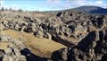 view gallery view gallerySW7.4 km |  Devils Garden - Klamath County, OR Devils Garden - Klamath County, OR
in Geological Devilish Locations A volcanic area located south of the OC&E Woodsline Trail. posted by: NW_history_buff location: Oregon date approved: 01/15/2018 last visited: never |
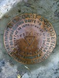
 view gallery view galleryNW10.3 km | NY0560 - USC&GS 'G 352' BM - Klamath County, OR in U.S. Benchmarks This NGS benchmark is located along Sprague River Road. posted by: NW_history_buff location: Oregon date approved: 06/17/2016 last visited: never |
 view gallery view gallery S12.2 km S12.2 km
| NY0325 - USC&GS 'F 350' - Klamath County, OR in U.S. Benchmarks This NGS benchmark is imbedded on top of a boulder just west of Egert Rd in Klamath County, OR. posted by: NW_history_buff location: Oregon date approved: 02/20/2013 last visited: never |
 view gallery view gallery NE12.9 km NE12.9 km
| USGS '29 DRS' BM - Klamath County, OR in U.S. Benchmarks This benchmark is located just off Oregon Pines Rd in Klamath County, OR posted by: NW_history_buff location: Oregon date approved: 11/09/2013 last visited: never |
 view gallery view gallery E13 km E13 km
|  106 - Jennie Clinton - Klamath County, OR 106 - Jennie Clinton - Klamath County, OR
in Headstones of Centenarians Aunt Jennie Clinton, over 100 years old (her exact age cannot be determined) and the last survivor of the Modoc War of 1872-1873, died in 1950 and is buried at Chief Schonchin Cemetery, a couple of miles north of Hwy 140 in Klamath County, OR. posted by: NW_history_buff location: Oregon date approved: 08/23/2012 last visited: never |
 view gallery view galleryE13 km |  Chief Schonchin Cemetery - Klamath County, OR Chief Schonchin Cemetery - Klamath County, OR
in Worldwide Cemeteries This Native American cemetery is located a couple of miles north of Hwy 140 in Klamath County, OR. posted by: NW_history_buff location: Oregon date approved: 08/29/2012 last visited: never |
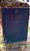 view gallery view galleryE13 km |  Chief Schonchin - Klamath County, OR Chief Schonchin - Klamath County, OR
in Oregon Historical Markers This Oregon Historical Marker is located inside Schonchin Cemetery in Klamath County, OR. posted by: NW_history_buff location: Oregon date approved: 09/06/2012 last visited: never |
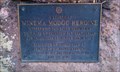 view gallery view galleryE13 km | Winema, Modoc Heroine - Klamath County, OR in Oregon Historical Markers What Sacagawea was to the East, Winema was to the West. She was instrumental as an interpreter and negotiator in helping to prevent major bloodshed between the Modoc and Klamath Indian tribes and the US Government in the 1870s. posted by: NW_history_buff location: Oregon date approved: 09/20/2012 last visited: never |
 view gallery view gallerySE13.8 km | NY0277 - USC&GS 'J 288' BM - Klamath Falls, OR in U.S. Benchmarks This NGS benchmark lies at the corner of Hwy 140 and Sprague River Rd in Klamath County, OR. posted by: NW_history_buff location: Oregon date approved: 10/17/2012 last visited: 10/04/2015 |
 view gallery view galleryNW14 km | NY0558 - USC&GS&SS 'T 277' BM - Klamath County, OR in U.S. Benchmarks This NGS benchmark is located along Sprague River Road. posted by: NW_history_buff location: Oregon date approved: 06/17/2016 last visited: never |
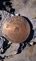 view gallery view gallerySE14.3 km | ODOT Bly Mountain 5 - Klamath County, OR in U.S. Benchmarks This benchmark is located just off of Hwy 140 on the right hand side of the road if your heading east in Bly Mountain Pass, in Klamath county, OR. posted by: NW_history_buff location: Oregon date approved: 06/28/2012 last visited: never |
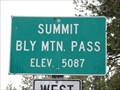 view gallery view gallerySE14.3 km |  Bly Mtn. Pass - 5087' Bly Mtn. Pass - 5087'
in Elevation Signs The sign is located on Highway 140 between Klamath Falls and Beatty. posted by: WR7X location: Oregon date approved: 05/28/2013 last visited: 10/10/2014 |
 view gallery view gallery W14.5 km W14.5 km
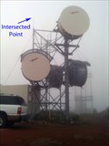
| NY0911 - SWAN LAKE PT BONNEVILLE MICROW - Klamath County, OR in U.S. Benchmarks This microwave tower is located at the summit of Swan Lake Point in Klamath County, OR. posted by: NW_history_buff location: Oregon date approved: 09/24/2013 last visited: never |
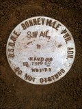 view gallery view galleryW14.5 km | USDOE Bonneville Power Adm 'SWAL' Control Point - Klamath County, OR in U.S. Benchmarks This Bonneville Power Administration control point is located directly under a microwave tower on the summit of Swan Lake Point in Klamath County, OR. posted by: NW_history_buff location: Oregon date approved: 09/24/2013 last visited: never |
 view gallery view galleryW14.5 km | CD8205 - USCGS 'SWAN LAKE NO 1' Reference Mark - Klamath County, OR in U.S. Benchmarks This NGS reference mark is located at the summit of Swan Lake Point in Klamath County, OR. posted by: NW_history_buff location: Oregon date approved: 09/24/2013 last visited: never |
 view gallery view galleryW14.5 km | NY0909 - USCGS 'SWAN LAKE' Triangulation Station - Klamath County, OR in U.S. Benchmarks This NGS triangulation station lies at the summit of Swan Lake Point in Klamath County, OR. posted by: NW_history_buff location: Oregon date approved: 09/24/2013 last visited: never |
 view gallery view galleryW14.5 km | CD8206 - USCGS 'SWAN LAKE NO 2' Reference Mark - Klamath County, OR in U.S. Benchmarks This NGS reference mark is located at the summit of Swan Lake Point in Klamath County, OR. posted by: NW_history_buff location: Oregon date approved: 09/24/2013 last visited: never |
 view gallery view galleryE14.8 km | NY0268 - USC&GS G 357 - Klamath County, OR in U.S. Benchmarks This NGS benchmark lies next to Hwy 140 in Klamath County, OR. posted by: NW_history_buff location: Oregon date approved: 10/17/2012 last visited: 10/04/2015 |
|