 view gallery view gallery N0.6 km N0.6 km
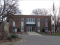
|   Onondaga, MI 49264 Onondaga, MI 49264
in U.S. Post Offices Small post office located in Onondaga, MI, part of Ingham County. posted by:  bobfrapples8 bobfrapples8 location: Michigan date approved: 12/28/2021 last visited: never |
 view gallery view gallery NE2.4 km NE2.4 km
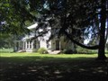
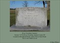
|  Lane Cemetery, Onondaga, Michigan Lane Cemetery, Onondaga, Michigan
in Worldwide Cemeteries Lane Cemetery posted by:  just for the fun just for the fun location: Michigan date approved: 02/13/2017 last visited: 04/28/2017 |
 view gallery view gallery S5.5 km S5.5 km
| Brown Cemetery in Worldwide Cemeteries Section 7 (T1S) Tompkins Township, Jackson County MI Located on Clinton Road (M-50), west of Hopcraft Road. posted by: woolsox location: Michigan date approved: 03/14/2011 last visited: 02/13/2017 |
 view gallery view gallery SW5.5 km SW5.5 km
|  Robbins Headstone - Tompkins Cemetery - Tompkins, Michigan Robbins Headstone - Tompkins Cemetery - Tompkins, Michigan
in Zinc Headstones This Zinc Headstone is for the William P and Elisabeth Robbins and is in the Tompkins cemetery. posted by: GT.US location: Michigan date approved: 10/01/2009 last visited: 02/13/2017 |
 view gallery view gallerySW5.5 km | Griffith Cemetery in Worldwide Cemeteries Section 1 (T1S) Springport Township, Jackson County MI Located on Clinton Road (M-50), east of Brown Road. posted by: woolsox location: Michigan date approved: 03/14/2011 last visited: 02/13/2017 |
 view gallery view gallery NW5.6 km NW5.6 km
|  VFW National Home VFW National Home
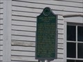
in Michigan Historical Markers Located on Aloha Hawaii Parkway (no I'm not kidding) on the east side of Waverly Road about 0.6 miles south of VFW Road. Parking available on-site. posted by: S5280ft location: Michigan date approved: 11/26/2006 last visited: 04/23/2021 |
 view gallery view galleryN6.1 km | Edward Ferris House in Michigan Historical Markers This private residence is on the west side of Onondaga Road between Stimpson and Ferris Roads. No parking available. The house is undergoing extensive renovation by the owner. posted by: S5280ft location: Michigan date approved: 07/16/2006 last visited: 04/23/2021 |
 view gallery view gallery E6.6 km E6.6 km
| Walker Cemetery in Worldwide Cemeteries Section 6 (T1S) Rives Township, Jackson County MI Located on Baseline Road, east of Berryville Road. posted by: woolsox location: Michigan date approved: 03/14/2011 last visited: 11/02/2015 |
 view gallery view galleryS6.9 km | Tompkins Cemetery in Worldwide Cemeteries Section 21 (T1S) Tompkins Township, Jackson County MI Located on Clinton Road (M-50) east of Onondaga Road. posted by: woolsox location: Michigan date approved: 03/14/2011 last visited: 02/13/2017 |
 view gallery view gallery SE7.1 km SE7.1 km
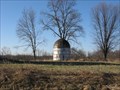
|  Short Silo - Berryville, MI Short Silo - Berryville, MI
in Solitary Silos Short Silo - Berryville, MI posted by: woolsox location: Michigan date approved: 05/17/2009 last visited: 11/02/2015 |
 view gallery view gallerySW7.2 km | Jameson Farm in Michigan Historical Markers Located on the west side of North Parma Road, just north of Pope Church Road. No real parking. You'll have to wing it. posted by: S5280ft location: Michigan date approved: 11/27/2006 last visited: 04/23/2021 |
 view gallery view gallerySW7.2 km |  James M. Jameson Farm - Springport, MI James M. Jameson Farm - Springport, MI
in Wikipedia Entries Located on the west side of North Parma Road, just north of Pope Church Road. Have to park on the two lane highway but traffic is fairly light. posted by: bobfrapples8 location: Michigan date approved: 12/27/2021 last visited: never |
 view gallery view gallerySW7.2 km | Pope Church Cemetery in Worldwide Cemeteries Section 18 (T1S) Tompkins Township, Jackson County MI Located on Pope Chruch Road, east of Parma Road. posted by: woolsox location: Michigan date approved: 03/14/2011 last visited: 02/13/2017 |
 view gallery view galleryNW7.7 km | Hamlin District No. 15 School in Michigan Historical Markers Located on the south side of Kinneville Highway, approximately 0.4 miles southeast of Houston Road. The building is now used as a daycare center. Parking is available on-site. posted by: S5280ft location: Michigan date approved: 11/26/2006 last visited: 04/23/2021 |
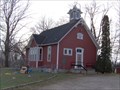
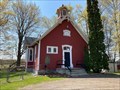 view gallery view galleryNW7.7 km |  Hamlin District No. 15 School - Eaton Rapids, MI Hamlin District No. 15 School - Eaton Rapids, MI
in One-Room Schoolhouses Located on the south side of Kinneville Highway, approximately 0.4 miles southeast of Houston Road. The building is now used as a daycare center. Parking is available on-site. posted by: bobfrapples8 location: Michigan date approved: 12/27/2021 last visited: never |
 view gallery view gallerySE8.4 km | Rives Township Cemetery in Worldwide Cemeteries Section 7 (T1S) Rives Township, Jackson County MI Located on Broughwell Road, south of Rives Eaton Road. posted by: woolsox location: Michigan date approved: 03/14/2011 last visited: 11/02/2015 |
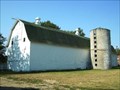 view gallery view galleryNW10.5 km | Miller Dairy Farm No. 1 in Michigan Historical Markers Located east of Eaton Rapids on the north side of State Road. posted by: S5280ft location: Michigan date approved: 08/26/2008 last visited: 03/08/2022 |
 view gallery view galleryNW10.5 km |  Miller Dairy Farm No. 1 - Eaton Rapids, MI Miller Dairy Farm No. 1 - Eaton Rapids, MI
in Barns A barn with a little local history. Thankfully the local Historical Society has taken on the preservation. posted by: S5280ft location: Michigan date approved: 08/23/2008 last visited: 04/23/2021 |
 view gallery view galleryNW10.6 km | Parma and Sheridan No. 7 School in Michigan Historical Markers Located in the Miller Farm property, it's gated off behind the barn. posted by: Historic Markers location: Michigan date approved: 04/14/2014 last visited: 11/08/2015 |
 view gallery view gallerySW10.6 km | Pierson Cemetery in Worldwide Cemeteries Section 9 (T1S) Springport Township, Jackson County MI Located on Gibbs Road, east of McClellan Road. posted by: woolsox location: Michigan date approved: 03/14/2011 last visited: 02/13/2017 |
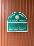 view gallery view galleryE10.6 km | City of Leslie, MI in Michigan Historical Markers Ingham County historical marker describing the city origins. posted by: bobfrapples8 location: Michigan date approved: 11/16/2021 last visited: never |
 view gallery view galleryE10.6 km |  1903 - G.A.R. Building - Leslie, MI 1903 - G.A.R. Building - Leslie, MI
in Dated Buildings and Cornerstones Built as the memorial hall for the Grand Army of the Republic and the Woman's Relief Corps in Leslie, MI in 1903. posted by: bobfrapples8 location: Michigan date approved: 12/27/2021 last visited: never |
 view gallery view galleryE10.6 km |  Leslie Area Historical Society & Museum - Leslie, MI Leslie Area Historical Society & Museum - Leslie, MI
in Historical Society Headquarters Leslie Historical Society/Museum is located in the Grand Army of the Republic Building built in 1903. posted by: bobfrapples8 location: Michigan date approved: 12/27/2021 last visited: never |
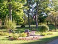 view gallery view galleryNW10.6 km |  RoseHill Cemetery Veterans Perrenial Garden - Eaton Rapids, MI RoseHill Cemetery Veterans Perrenial Garden - Eaton Rapids, MI
in Non-Specific Veteran Memorials This Veterans memorial is a Perrenial Garden in the Rose Hill Cemetery. posted by: GT.US location: Michigan date approved: 10/01/2009 last visited: 11/08/2015 |
![Image for First Baptist Church [of Leslie]](https://img.geocaching.com/waymarking/small/fe4ad771-c59a-4b93-875b-7419cbfcb9f2.jpg) view gallery view galleryE10.8 km | First Baptist Church [of Leslie] in Michigan Historical Markers On the northeast corner of Church and East Bellview Streets. Streetside parking available. posted by: S5280ft location: Michigan date approved: 07/16/2006 last visited: 04/23/2021 |
|