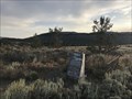
 view gallery view gallery N5.6 km N5.6 km
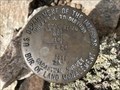
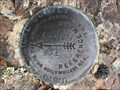
|   T29N R100W MS50 GC 10 S20 - Fremont County, Wyoming T29N R100W MS50 GC 10 S20 - Fremont County, Wyoming
in Public Land Survey Marks A USDI-Bureau of Land Management mining claim corner mark to the southeast of the historic Franklin Mine, west of South Pass City. posted by:  Tom.dog Tom.dog location: Wyoming date approved: 04/29/2024 last visited: never |
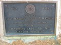 view gallery view galleryN5.6 km |  FIRST - Masonic Lodge in Wyoming FIRST - Masonic Lodge in Wyoming
in First of its Kind First Masonic Lodge in Wyoming (1869-1925) marker is located in South Pass City next to the South Pass City Mercantile. posted by: Rose Red location: Wyoming date approved: 07/07/2007 last visited: 09/16/2011 |
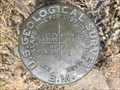
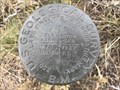
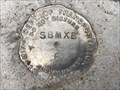
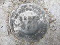
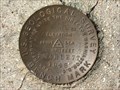
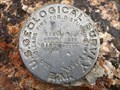 view gallery view galleryN8.2 km |  8162 (NS0037) - Fremont County, Wyoming 8162 (NS0037) - Fremont County, Wyoming
in U.S. Benchmarks This USGS benchmark sits roughly halfway between Atlantic City and South Pass City, placing it in the central part of Wyoming's most productive gold mining district. posted by: Tom.dog location: Wyoming date approved: 10/12/2023 last visited: never |
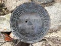
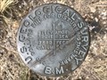 view gallery view gallery SW9.7 km SW9.7 km
| 7569 RL - Fremont County, Wyoming in U.S. Benchmarks This USGS pipe cap sits southwest of the Sweetwater River in the South Pass area. posted by: Tom.dog location: Wyoming date approved: 08/27/2023 last visited: never |
 view gallery view gallery W13 km W13 km
| 7635 RL - Fremont County, Wyoming in U.S. Benchmarks A USGS pipe cap to the northeast of the Lander Cutoff Road. posted by: Tom.dog location: Wyoming date approved: 08/27/2023 last visited: never |
 view gallery view gallery NE13.4 km NE13.4 km
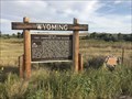
|  Miners Delight: The Boom's Broken Promises - Atlantic City, Wyoming Miners Delight: The Boom's Broken Promises - Atlantic City, Wyoming
in Wyoming Historical Markers This historical marker has been set up at the junction of Dickinson Avenue and Fort Stambaugh Road; the well-preserved ghost town of Miners Delight that the marker describes can be explored if one travels eastward down Fort Stambaugh Road. posted by: Tom.dog location: Wyoming date approved: 08/26/2023 last visited: never |
 view gallery view galleryW14.2 km | ACORN NO 2 - Fremont County, Wyoming in U.S. Benchmarks Reference mark 2 for destroyed USGS benchmark ACORN (NS0234), located very near the top of a hill on the Continental Divide. posted by: Tom.dog location: Wyoming date approved: 08/27/2023 last visited: never |
 view gallery view galleryW14.3 km | ACORN NO 1 - Fremont County, Wyoming in U.S. Benchmarks Reference mark 1 for destroyed USGS benchmark ACORN (NS0234), set near the summit of a large hill that rises to the southwest of the Sweetwater River and straddles the Continental Divide. posted by: Tom.dog location: Wyoming date approved: 08/27/2023 last visited: never |
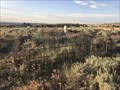
 view gallery view gallerySW14.6 km |  South Pass Scenic Overlook, Wyoming South Pass Scenic Overlook, Wyoming
in Scenic Roadside Look-Outs I traveled The Oregon Trail with an Elderhostel group from Kansas City/Independence, Missouri to Oregon City, Oregon June 13-28, 2007. posted by: Rose Red location: Wyoming date approved: 07/07/2007 last visited: 08/18/2009 |
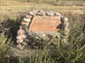
 view gallery view galleryNE16.4 km |  Miners Delight Cemetery - Miners Delight, Wyoming, USA Miners Delight Cemetery - Miners Delight, Wyoming, USA
in Worldwide Cemeteries This abandoned and overgrown cemetery sits to the south of the gold mining ghost town of Miners Delight, located on the southeastern end of the Wind River Range. posted by: Tom.dog location: Wyoming date approved: 08/26/2023 last visited: never |
 view gallery view galleryNE16.4 km |  Miners Delight Cemetery - Miners Delight, Wyoming Miners Delight Cemetery - Miners Delight, Wyoming
in Abandoned Cemeteries This is the abandoned cemetery for the ghost town of Miners Delight, which is now overgrown with sagebrush and small pines. posted by: Tom.dog location: Wyoming date approved: 08/28/2023 last visited: never |
 view gallery view galleryW16.7 km | 7759 RL - Fremont County, Wyoming in U.S. Benchmarks This USGS pipe cap sits just to the northeast of a unnamed two-track road. posted by: Tom.dog location: Wyoming date approved: 08/27/2023 last visited: never |
 view gallery view galleryW18.2 km | SKULL (NS0284) - Fremont County, Wyoming in U.S. Benchmarks This USGS triangulation station is set along a low ridge in the remote southwestern corner of Fremont County. posted by: Tom.dog location: Wyoming date approved: 08/27/2023 last visited: never |
 view gallery view galleryW18.5 km | BONES (NS0285) - Fremont County, Wyoming in U.S. Benchmarks A USGS triangulation station located very near the Continental Divide and just to the south of the Lander Cutoff Road. posted by: Tom.dog location: Wyoming date approved: 08/27/2023 last visited: never |
 view gallery view gallerySW25.6 km | "Parting of the Ways," Wyoming in Wyoming Historical Markers I traveled The Oregon Trail with an Elderhostel group from Kansas City/Independence, Missouri to Oregon City, Oregon June 13-28, 2007. We stopped at "Parting of the Ways" on our way to Farson, Wyoming on Thursday, June 21. posted by: Rose Red location: Wyoming date approved: 12/23/2007 last visited: 10/10/2022 |
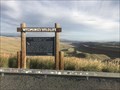 view gallery view galleryNE25.9 km |  Red Canyon Wildlife Habitat Management Area - Fremont County, Wyoming Red Canyon Wildlife Habitat Management Area - Fremont County, Wyoming
in Flora and Fauna Information Signs A Wyoming's Wildlife sign at a scenic view area overlooking Red Canyon, just off the side of State Highway 28. posted by: Tom.dog location: Wyoming date approved: 08/27/2023 last visited: never |
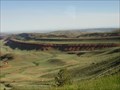 view gallery view galleryNE26.2 km | Red Canyon Scenic Overlook, Wyoming in Scenic Roadside Look-Outs We stopped briefly at Red Canyon Scenic Overlook on our way to South Pass City State Historic Site. posted by: Rose Red location: Wyoming date approved: 07/07/2007 last visited: 09/16/2011 |
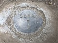
 view gallery view gallery NW43.3 km NW43.3 km
| SBMXB 6 - Sublette County, Wyoming in U.S. Benchmarks This Wyoming Department of Transportation survey marker sits in between the lower switchback of Muddy Ridge Road and the Big Sandy River. posted by: Tom.dog location: Wyoming date approved: 10/12/2023 last visited: never |
 view gallery view galleryNW43.5 km | SBMXB 5 - Sublette County, Wyoming in U.S. Benchmarks A Wyoming Department of Transportation survey marker at a switchback in Muddy Ridge Road. posted by: Tom.dog location: Wyoming date approved: 10/12/2023 last visited: never |
 view gallery view galleryNW43.5 km | SBMXB 7 - Sublette County, Wyoming in U.S. Benchmarks A State Highway Department survey marker a short ways to the north of a single-lane bridge over the Big Sandy River. posted by: Tom.dog location: Wyoming date approved: 10/12/2023 last visited: never |
 view gallery view galleryNW43.6 km | SBMXB 8 - Sublette County, Wyoming in U.S. Benchmarks This survey marker can be found on the west side of Muddy Ridge Road. posted by: Tom.dog location: Wyoming date approved: 10/12/2023 last visited: never |
 view gallery view galleryN46.7 km |  "Wildwood" Clock, Lander, Wyoming "Wildwood" Clock, Lander, Wyoming
in Town Clocks I traveled The Oregon Trail with an Elderhostel group from Kansas City/Independence, Missouri to Oregon City, Oregon June 13-28, 2007. I explored part of Main Street in downtown Lander, Wyoming where I came across the stained glass clock.
posted by: Rose Red location: Wyoming date approved: 07/06/2007 last visited: 05/03/2009 |
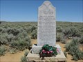
 view gallery view galleryN49.1 km | Site of Fort Thompson or Camp Magraw - Lander, Wyoming in Wyoming Historical Markers This marker, located on the northwest side of State Highway 789, describes the history of the U.S. settlement of the Lander region. posted by: Tom.dog location: Wyoming date approved: 08/26/2023 last visited: never |
 view gallery view galleryN49.1 km | Site of Fort McGraw - Lander, Wyoming in Wyoming Historical Markers This stone and concrete monument, erected by the Boy Scouts of America, marks the historic site of Fort Magraw (aka Fort Thompson) outside of Lander, Wyoming. posted by: Tom.dog location: Wyoming date approved: 08/26/2023 last visited: never |
 view gallery view gallery E57.9 km E57.9 km
| SCARLETT (NS0158) - Fremont County, Wyoming in U.S. Benchmarks A USGS benchmark on top of a low hill that overlooks the Sweetwater River. posted by: Tom.dog location: Wyoming date approved: 08/27/2023 last visited: never |
|