 view gallery view gallery SW0.3 km SW0.3 km
|   Applebee's - N. Quincy, MA Applebee's - N. Quincy, MA
in Applebee's Restaurants This Applebee's in N. Quincy, Massachusetts, if a favorite stop, with easy access from I-93. Take Exit 12, cross the Neponset Bridge and exit onto Hancock St. It is in a small strip mall with a Panera opposite. posted by:  silverquill silverquill location: Massachusetts date approved: 08/15/2009 last visited: never |
 view gallery view gallery NE0.8 km NE0.8 km
|  Baskin Robbins, Quincy Shore Dr. - Quincy, MA Baskin Robbins, Quincy Shore Dr. - Quincy, MA
in Ice Cream Parlors This is a Baskin Robbins/Dunkin Donuts combo store at the intersection of Quincy Shore Dr & Squantum St in Quincy, Massachusetts. Though there is specatcular view of the bay, access is tricky at this divided interesection and miniscule parking area. posted by: silverquill location: Massachusetts date approved: 11/28/2008 last visited: never |
 view gallery view galleryNE0.8 km |  Dunkin Donuts, Quincy Shore Dr. - Quincy, MA Dunkin Donuts, Quincy Shore Dr. - Quincy, MA
in Dunkin Donuts' This is a Dunkin Donuts - Baskin Robbins combo store at the busy intersection of Quincy Shore Dr. and Squantum St., with a fantastic view of the bay. The miniscule parking area and divided intersection, though, make access tricky! posted by: silverquill location: Massachusetts date approved: 11/29/2008 last visited: never |
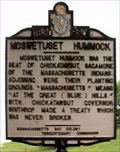 view gallery view galleryNE1 km |  Moswetuset Hummock - Quincy, MA Moswetuset Hummock - Quincy, MA
in Massachusetts Historical Markers This is believed to be the site that give rise to the name "Massachusetts" for our state. It is located along Quincy Shore Drive near the intesection with Squantum St. with great views over the bay. posted by: silverquill location: Massachusetts date approved: 11/30/2008 last visited: never |
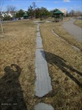
 view gallery view galleryNE1 km |  Moswetuset Hummock Park - Quincy, MA Moswetuset Hummock Park - Quincy, MA
in Municipal Parks and Plazas Moswetuset Hummock Park is a scenic area located along beautiful Quincy Shore Drive with stunning panoramas of the bay. This is a favorite jogging are, and viewing spot for sunrises. This also to be the site giving rise to the name Massachusetts. posted by: silverquill location: Massachusetts date approved: 11/28/2008 last visited: 10/14/2009 |
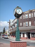 view gallery view gallery NW1.3 km NW1.3 km
|  Neponset Clock - Boston, MA Neponset Clock - Boston, MA
in Town Clocks This freestanding clock is just off the Southeast Exressway at the intersection Gallivan, Neponset and Morrisey Blvds. as you enter the Neponset community in the Dorchester section of Boston, Massachusetts. posted by: silverquill location: Massachusetts date approved: 06/27/2007 last visited: never |
 view gallery view galleryNW1.6 km |  Garvey Playground - Boston, MA Garvey Playground - Boston, MA
in Outdoor Basketball Courts A well maintained full court in the Garvery Playground, Boston, Massachusetts. The park also feature several baseball fields and a playground. posted by: silverquill location: Massachusetts date approved: 10/24/2007 last visited: never |
 view gallery view galleryNW1.6 km |  Garvey Playground - Boston, MA Garvey Playground - Boston, MA
in Public Playgrounds This park features a modern, well-equipped playground area as well as a basketball court and several baseball fields. posted by: silverquill location: Massachusetts date approved: 10/23/2007 last visited: never |
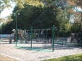 view gallery view galleryNW1.6 km | Garvey Playground - Boston, MA in Municipal Parks and Plazas Part of the City of Boston park system, Garvey Playgound also features a full basketball court and several baseball fields. posted by: silverquill location: Massachusetts date approved: 10/22/2007 last visited: never |
 view gallery view gallery S1.6 km S1.6 km
|  230 Safford St. - Quincy, MA 230 Safford St. - Quincy, MA
in 'Marry Me' Markers It was the Blizzard of '78. We had met on Jan. 13 and had one date after that, but it was enough. On Feb. 14, the driving ban was lifted to make it from New Haven, Conn. to Quincy, Mass. with roses and diamond ring, to propose on bended knee. posted by: silverquill location: Massachusetts date approved: 03/09/2009 last visited: 08/31/2012 |
 view gallery view gallery SE1.8 km SE1.8 km
|  Eastern Nazarene College, Quincy, MA Eastern Nazarene College, Quincy, MA
in Universities and Colleges Eastern Nazarene College in Quincy, MA, is a Christian four-year liberal arts college affiliated with the Church of the Nazarene. posted by: silverquill location: Massachusetts date approved: 05/31/2006 last visited: never |
 view gallery view gallerySE1.8 km |  Wollaston Church of the Nazarene - Quincy, MA Wollaston Church of the Nazarene - Quincy, MA
in Church of the Nazarene The Wollaston Church of the Nazarene is located on the campus of Eastern Nazarene College. It serves as the college church and chapel, but also has a strong community outreach. posted by: silverquill location: Massachusetts date approved: 05/17/2011 last visited: never |
 view gallery view gallerySE1.8 km |  Nease Library Eastern Nazarene College - Quincy, MA Nease Library Eastern Nazarene College - Quincy, MA
in Libraries This is the library for Eastern Nazarene College in Quincy, MA posted by: silverquill location: Massachusetts date approved: 04/20/2007 last visited: never |
 view gallery view gallerySW1.9 km |  Milton/Quincy Town Border Marker - Squantum St. Milton/Quincy Town Border Marker - Squantum St.
in U.S. Historic Survey Stones and Monuments A stone marker delineating the border between Quincy, MA and Milton, MA on Squantum St. posted by:  tdblalock tdblalock location: Massachusetts date approved: 09/15/2010 last visited: never |
 view gallery view gallery W1.9 km W1.9 km
| Shoreline Granite Markers - Neponset River Reservation - Boston, MA in Massachusetts Historical Markers A little in from the present shoreline is a line of granite slabs laid in the dirt marking the previous shoreline to the river. posted by: NorStar location: Massachusetts date approved: 03/31/2018 last visited: never |
 view gallery view galleryW2.1 km |  Mark S. Charbonnier and Richard T. Dever, Neponset River Reservation - Boston, MA Mark S. Charbonnier and Richard T. Dever, Neponset River Reservation - Boston, MA
in Police Memorials Charbonnier and Dever grew up in the Meeting House Hill area, served in different law enforcement units, died tragically, and are memorialized together, here. posted by: NorStar location: Massachusetts date approved: 03/08/2018 last visited: never |
 view gallery view gallery N2.1 km N2.1 km
| Squantum Point Through Time in Massachusetts Historical Markers This marker, one of many in Squantum Point Park, is about the change in the landscape at Squantum Point over the last few thousand years. posted by: NorStar location: Massachusetts date approved: 09/28/2007 last visited: never |
 view gallery view galleryW2.1 km |  Tidal/River Gauge at Granite Avenue Bridge - Boston, MA Tidal/River Gauge at Granite Avenue Bridge - Boston, MA
in River Gauges This vertical staff gauge records the water level at the drawbridge, which is within a sizeable estuary. posted by: NorStar location: Massachusetts date approved: 03/10/2018 last visited: never |
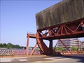 view gallery view galleryW2.1 km |  Granite St. Neponset River Bridge - Milton/Boston, MA Granite St. Neponset River Bridge - Milton/Boston, MA
in Moving Bridges The basic structure of this drawbridge was built in 1914, spanning the Neponset River with the town of Milton to the south, and Boston, Massachusetts to the North. posted by: silverquill location: Massachusetts date approved: 06/27/2007 last visited: 02/17/2018 |
 view gallery view galleryW2.1 km | Neponset River Reservation - Boston, MA in Municipal Parks and Plazas The Neponset River forms Boston's southern border with Quincy and Milton. Despite its history as an industrial center,many scenic vistas remain. Partially built on the old Granite Railway Corporation line. Open dawn to dusk. posted by: silverquill location: Massachusetts date approved: 05/06/2007 last visited: 02/17/2018 |
 view gallery view galleryW2.1 km |  FIRST - Incorprated Commercial Railway in the United States - Boston, MA FIRST - Incorprated Commercial Railway in the United States - Boston, MA
in First of its Kind The Granite Railway Corporation was the first incorporated commercial railway in the United States. The railway was initially built to transport granite from the Quincy Quarries to Gulliver's Creek Wharf<BR>
to build the Bunker Hill Monument. posted by: silverquill location: Massachusetts date approved: 05/06/2007 last visited: 02/17/2018 |
 view gallery view galleryW2.1 km | 1836 - 1870 Granite Railway Corporation - Boston, MA in Massachusetts Historical Markers The Granite Railway Corporation was the first incorporated railway in the United States transporting granite from the Quincy Quarries to Guller's Creek Wharf. posted by: NorStar location: Massachusetts date approved: 03/06/2018 last visited: never |
 view gallery view galleryN2.1 km |  Vietnam War Memorial, Clock Tower, Quincy, MA, USA Vietnam War Memorial, Clock Tower, Quincy, MA, USA
in Vietnam War Memorials Vietnam War memorial clock tower located at the Marina, Victory Lane, Quincy, Massachusetts. posted by: HANSENNI location: Massachusetts date approved: 09/27/2009 last visited: 10/18/2009 |
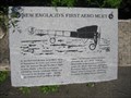 view gallery view galleryN2.1 km | New England's First Aero Meet in Massachusetts Historical Markers This engraved granite block, one of many at Squantum Point Park, is about an historic aero meet, which was attended by many famous people including one of the Wright Brothers. posted by: NorStar location: Massachusetts date approved: 09/28/2007 last visited: 07/26/2011 |
 view gallery view galleryW2.1 km |  Granite Avenue Bascule Bridge - 1959 - Boston-Quincy, MA Granite Avenue Bascule Bridge - 1959 - Boston-Quincy, MA
in Bridge Date Stones and Plaques This bascule bridge over the Neponset River between Boston and Quincy, built in 1959, replaced an older bridge built in 1914. posted by: NorStar location: Massachusetts date approved: 03/04/2018 last visited: never |
|