 view gallery view gallery NE7.4 km NE7.4 km
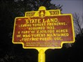
|   State Land State Land
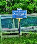
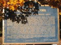
in New York Historical Markers State Land NY Historical Marker located on Rt. 42 in Lexington. posted by:  Team Smokey Team Smokey location: New York date approved: 11/04/2008 last visited: never |
 view gallery view gallery SW9.3 km SW9.3 km
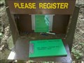
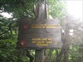
|  Seager / Big Indian Trail - Seager, NY Seager / Big Indian Trail - Seager, NY
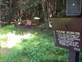
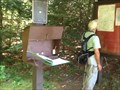
in Trail Registers This trail head is located at the end of Dry Brook Rd in Seager, NY. It has multiple purposes. Some use it for short hikes to nearby falls. Others use it as a start point for a few of the Catskill 3500 peaks. posted by:  bhouston21 bhouston21 location: New York date approved: 09/08/2011 last visited: never |
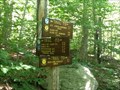
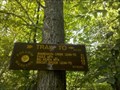 view gallery view gallerySW9.3 km |  Seager / Big Indian Trail Seager / Big Indian Trail
in Hiking and walking trailheads This trail head is located at the end of Dry Brook Rd in Seager, NY. It has multiple purposes. Some use it for short hikes to nearby falls. Others use it as a start point for a few of the Catskill 3500 peaks. posted by: bhouston21 location: New York date approved: 08/26/2011 last visited: never |
 view gallery view gallery W9.3 km W9.3 km
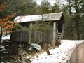
|  Forge Covered Bridge Forge Covered Bridge
in Covered Bridges This covered bridge just off Dry Brook Rd in Seager, NY. It crosses Dry Brook onto private property and is closed to general traffic. posted by: bhouston21 location: New York date approved: 08/25/2011 last visited: never |
 view gallery view gallerySW9.3 km | Tappan Bridge in Covered Bridges This covered bridge just off Dry Brook Rd in Seager, NY. It crosses Dry Brook onto Ericson Rd. posted by: bhouston21 location: New York date approved: 08/26/2011 last visited: never |
 view gallery view gallery E11.1 km E11.1 km
|  Brio's Pizzeria & Restaurant - Phoenicia, NY Brio's Pizzeria & Restaurant - Phoenicia, NY
in Neon Signs Brio's, a local Phoenicia Restaurant, has been proudly serving breakfast, lunch and dinner since 1973. posted by: nomadwillie location: New York date approved: 09/23/2019 last visited: never |
 view gallery view galleryE11.6 km |  Phoenicia Railroad Station - Phoenicia NY Phoenicia Railroad Station - Phoenicia NY
in Train Stations/Depots The Phoenicia Station was built at the same time the narrower gauge railroad was converted to standard gauge track. This opened this area of the Catskills to some of the more prominent hotels and resorts. posted by: nomadwillie location: New York date approved: 06/18/2013 last visited: never |
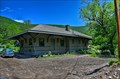 view gallery view galleryE11.6 km |  Phoenicia Railroad Station - Phoenicia NY Phoenicia Railroad Station - Phoenicia NY
in U.S. National Register of Historic Places The Phoenicia Station was built at the same time the narrower gauge railroad was converted to standard gauge track. This opened this area of the Catskills to some of the more prominent hotels and resorts. posted by: nomadwillie location: New York date approved: 06/18/2013 last visited: never |
 view gallery view galleryE11.6 km | Phoenicia Station - Phoenicia NY in New York Historical Markers Located right outside of the Empire State Railway Museum posted by: nomadwillie location: New York date approved: 12/01/2013 last visited: never |
 view gallery view gallery SE12.6 km SE12.6 km
|  Highest Point in Ulster County (New York State) Highest Point in Ulster County (New York State)
in Geographic High Points Slide Mountain is the highest point in Ulster County. posted by: weathernowcast location: New York date approved: 07/15/2010 last visited: 12/03/2016 |
 view gallery view gallery S13.4 km S13.4 km
| Phonicia-East Branch (Denning) Trail - Catskills, NY in Hiking and walking trailheads See notes on trail register waymark... This trail ultimately, can take you far. posted by: sagefemme location: New York date approved: 08/24/2014 last visited: never |
 view gallery view galleryS13.4 km | Phonicia-East Branch Trailhead - Denning, NY in Trail Registers The first 1.2 miles of this trail is also the last 1.2 miles of the Finger Lakes Trail. At that point it intersects with the Peekamoose-Table Trail. The Phonicia-East Branch Trail continues to the left and intersects with Curtis-Ormsbee Trail. posted by: sagefemme location: New York date approved: 09/01/2014 last visited: never |
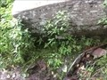
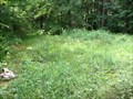 view gallery view gallerySW13.7 km |  Fall Brook bivouac site - Catskills, NY Fall Brook bivouac site - Catskills, NY
in Free Campsites Somewhat overgrown, I walked past this bivouac site the first time through. It is situated on a small natural meadow beside Fall Brook between the Balsam Lake Mountain DEC parking and the Fall Brook Leanto. posted by: sagefemme location: New York date approved: 08/20/2014 last visited: never |
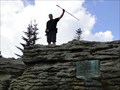
 view gallery view gallerySE13.8 km | Catskill Mountains - Shandaken Area in New York Historical Markers Catskill Mountains - Shandaken Area NY Historical Marker located on Rt. 28 in Shandaken. posted by: Team Smokey location: New York date approved: 11/04/2008 last visited: never |
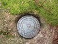
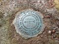 view gallery view gallerySW13.8 km |  CZ7448 - Balsam Lake Mountain Reference Marker No. 1 CZ7448 - Balsam Lake Mountain Reference Marker No. 1
in U.S. Benchmarks Reference marker stamped Balsam 1940 is situated between the fire tower and the triangulation disk about 53 ft north of this disk. All easily seen while walking the summit of Balsam Lake Mountain posted by: sagefemme location: New York date approved: 08/04/2014 last visited: never |
 view gallery view gallerySW14 km | NA2072 - Balsam Lake Mountain triangulation station in U.S. Benchmarks Found in the balsam grove near the fire tower. Also found a reference maker pointing to this disk near the caretakers cottage. posted by: sagefemme location: New York date approved: 07/29/2014 last visited: never |
 view gallery view gallerySW14 km |  Balsam Lake Mountain - Catskills, NY Balsam Lake Mountain - Catskills, NY
in Mountain Summits Balsam Lake Mountain is one of the 35 Catskill peaks over 3500 ft elevation. This is the only Catskill 35 over 3500 that is (nearly) on the Finger Lakes Trail. It also offers one of only 5 remaining fire tower - turned lookout tower. posted by: sagefemme location: New York date approved: 08/02/2014 last visited: never |
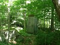
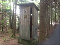 view gallery view gallerySW14 km |  Balsam Lake Mountain summit outhouse Balsam Lake Mountain summit outhouse
in Outhouses It's good to know you can leave a dump anywhere, even over 3500 feet above sea level. posted by: sagefemme location: New York date approved: 07/27/2014 last visited: never |
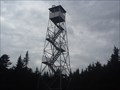 view gallery view gallerySW14 km |  Balsam Lake Mountain Overlook Tower - Catskills, NY Balsam Lake Mountain Overlook Tower - Catskills, NY
in Look-Out Towers One of only five (5) remaining former fire towers in the Catskills managed by the Department of Energy and Conservation (DEC). posted by: sagefemme location: New York date approved: 07/27/2014 last visited: never |
 view gallery view gallerySW14.2 km | Highest elevation on the Finger Lakes Trail (FLT) in Geographic High Points Less than a mile from the summit of Balsam Lake Mountain, it is over 3500 feet above sea level. posted by: sagefemme location: New York date approved: 07/31/2014 last visited: never |
 view gallery view gallerySW14.2 km |  Balsam Lake Mountain spring - Catskills, NY Balsam Lake Mountain spring - Catskills, NY
in Natural Springs This is the water source for a Leanto and bivouac site just below the 3500 foot elevation mark on the trail to the summit of Balsam Lake Mountain. posted by: sagefemme location: New York date approved: 08/20/2014 last visited: never |
 view gallery view galleryS14.3 km | Eastern Terminus - Finger Lakes Trail - New York in Long Distance Hiking Trails This is a very significant coordinate for those who are attempting to earn credit for End-to-end status on the Finger Lakes Trails, as it is the easternmost end, and the hardest to get to, much less hike. posted by: sagefemme location: New York date approved: 08/20/2014 last visited: never |
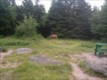
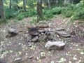 view gallery view gallerySW14.3 km | Balsam Lake Mountain bivouac sites - Catskills, NY in Free Campsites The Finger Lakes Trails maps identify the Leanto on Balsam Lake Mountain, but I was surprised to discover a warren of trails all around the Leanto to level patches of ground where tents could be put up as well. posted by: sagefemme location: New York date approved: 08/20/2014 last visited: never |
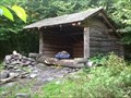 view gallery view gallerySW14.3 km |  Balsam Lake Mountain Leanto - Catskills, NY Balsam Lake Mountain Leanto - Catskills, NY
in Remote Backcountry Shelters This Leanto sits just .1 mile from the trail from Balsam Lake to the summit of Balsam Lake Mountain just below the 3500 foot elevation level. posted by: sagefemme location: New York date approved: 08/21/2014 last visited: never |
 view gallery view gallerySW14.8 km | Fall Brook Shelter outhouse - Catskills, NY in Outhouses This one-holer is designed to support through-hikers on the Finger Lakes Trail (FLT) or anyone else seeking to overnight in the back-woods. posted by: sagefemme location: New York date approved: 08/21/2014 last visited: never |
|