 view gallery view gallery S4.5 km S4.5 km
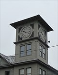
|   Millerton Movie House Clock - Millerton NY Millerton Movie House Clock - Millerton NY
in Town Clocks Located at 48 Main Street, Millerton, NY posted by:  nomadwillie nomadwillie location: New York date approved: 05/23/2011 last visited: 07/23/2010 |
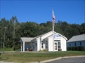
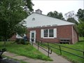 view gallery view galleryS4.7 km |  Millerton, NY 12546 Millerton, NY 12546
in U.S. Post Offices Located at 33 Century Boulevard, Millerton, NY posted by: nomadwillie location: New York date approved: 05/22/2011 last visited: 07/23/2010 |
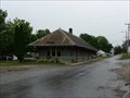 view gallery view galleryS4.7 km |  Millerton (NYCRR station) - Millerton NY Millerton (NYCRR station) - Millerton NY
in Train Stations/Depots Located at 20 N.Center Street Millerton, New York posted by: nomadwillie location: New York date approved: 06/08/2011 last visited: 07/24/2015 |
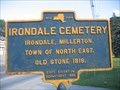 view gallery view galleryS4.7 km |  Irondale Cemetery Irondale Cemetery
in New York Historical Markers Irondale Cemetery NY Historical Marker posted by: Team Smokey location: New York date approved: 07/20/2007 last visited: never |
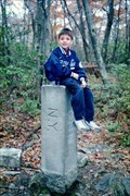 view gallery view gallery N6.4 km N6.4 km
|  New York/Connecticut/Massachusetts Tripoint New York/Connecticut/Massachusetts Tripoint
in Tripoints and Multipoints Stone marker denoting the point where New York, Connecticut and Massachusetts come together. posted by: hykesj location: Connecticut date approved: 12/08/2021 last visited: never |
 view gallery view gallery NE6.6 km NE6.6 km
|  Highest Point in Connecticut Highest Point in Connecticut
in Geographic High Points The highest point in Connecticut lies on the southern slope of Mt. Frissell in the extreme northwest corner of the state. posted by: hykesj location: Connecticut date approved: 12/18/2021 last visited: never |
 view gallery view gallery W6.8 km W6.8 km
| Ancramdale, NY 12503 in U.S. Post Offices Ancramdale, NY 12503 US Post Office posted by: Team Smokey location: New York date approved: 09/02/2007 last visited: never |
 view gallery view galleryNE6.8 km |  Mt. Frissell - Western Massachusetts Mt. Frissell - Western Massachusetts
in Mountain Summits Mt. Frissell, in Massachusetts, is best known as the highpoint of the neighboring state of Connecticut. posted by: hykesj location: Massachusetts date approved: 12/10/2021 last visited: never |
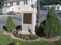 view gallery view galleryW6.8 km |  Ancramdale Multi-War Memorial Ancramdale Multi-War Memorial
in Non-Specific Veteran Memorials Ancramdale Multi-War Memorial posted by: Team Smokey location: New York date approved: 09/08/2007 last visited: never |
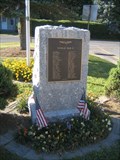 view gallery view galleryW6.8 km |  Ancramdale World War II Memorial Ancramdale World War II Memorial
in World War II Memorials / Monuments Ancramdale World War II Memorial posted by: Team Smokey location: New York date approved: 09/08/2007 last visited: never |
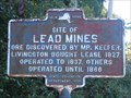 view gallery view galleryW6.9 km | Site of Lead Mines in New York Historical Markers Site of Lead Mines NY Historical Marker located on Rt. 82 in Ancramdale. posted by: Team Smokey location: New York date approved: 09/03/2007 last visited: never |
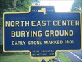 view gallery view galleryS7.2 km | North East Center Burying Ground in New York Historical Markers North East Center Burying Ground NY Historical Marker posted by: Team Smokey location: New York date approved: 07/20/2007 last visited: never |
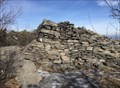 view gallery view galleryNE7.6 km |  Cairn, Summit of Bear Mountain, Salisbury, CT Cairn, Summit of Bear Mountain, Salisbury, CT
in Cairns A cairn at the summit of Bear Mountain posted by:  chrissyml chrissyml location: Connecticut date approved: 02/07/2021 last visited: never |
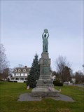 view gallery view gallery E7.7 km E7.7 km
|  Columbia-Union-Freedom Soldiers' Monument - Salisbury, CT Columbia-Union-Freedom Soldiers' Monument - Salisbury, CT
in American Civil War Monuments and Memorials The Columbia-Union-Freedom Soldiers' Monument is located at East main Street at the junction of U.S. Route 44 and Route 41 in Salisbury, CT posted by:  neoc1 neoc1 location: Connecticut date approved: 05/31/2013 last visited: never |
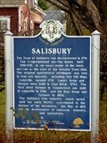 view gallery view galleryE7.7 km |  Salisbury Historical Marker - Salisbury, CT Salisbury Historical Marker - Salisbury, CT
in Connecticut Historical Markers The Salisbury Historical Marker is located at the intersection of Main Street and Academy Street in Salisbury, CT posted by: neoc1 location: Connecticut date approved: 10/08/2022 last visited: never |
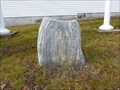 view gallery view galleryE7.9 km |  Salisbury to Boston Mile Marker - Salisbury, CT Salisbury to Boston Mile Marker - Salisbury, CT
in Milestones A mile marker in Salisbury, CT is located in front to the Town Hall at 27 Main Street, US Route 44, in Salisbury, CT posted by: neoc1 location: Connecticut date approved: 10/07/2022 last visited: never |
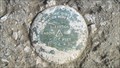 view gallery view gallery NW8.2 km NW8.2 km
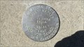
|  L 24 WE 1942 (USGS, Ancramdale, NY) L 24 WE 1942 (USGS, Ancramdale, NY)
in U.S. Benchmarks A USGS standard bench mark disk, located in Ancramdale, NY. posted by: NH2beers location: New York date approved: 04/09/2016 last visited: never |
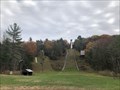 view gallery view galleryE8.4 km |  Satre Hill - Salisbury, Connecticut Satre Hill - Salisbury, Connecticut
in Ski Jumps Located on the east side of Salisbury. posted by: flyingmoose location: Connecticut date approved: 10/29/2020 last visited: never |
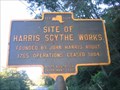 view gallery view galleryW10.8 km | Site of Harris Scythe Works in New York Historical Markers Site of Harris Scythe Works NY Historical Marker located on Rt. 82 in Pine Plains. posted by: Team Smokey location: New York date approved: 09/03/2007 last visited: never |
 view gallery view galleryNW11.6 km | TT 19 MC RESET (NYDOT/USGS, Ancram, NY) in U.S. Benchmarks A NYDOT standard disk, located in Ancram, NY. posted by: NH2beers location: New York date approved: 04/09/2016 last visited: never |
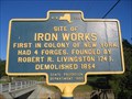 view gallery view galleryNW11.7 km | Site of Iron Works in New York Historical Markers Site of Iron Works NY Historical Marker located on Rt. 82 in Ancram. posted by: Team Smokey location: New York date approved: 09/02/2007 last visited: never |
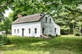 view gallery view galleryW11.7 km |  Graham--Brush Log House - Pine Plains NY Graham--Brush Log House - Pine Plains NY
in Pre-Victorian Historic Homes Graham-Brush Log House was built in about 1776 and is a two-room log structure with a wood frame lean-to on its rear elevation. The Brush house was acquired in 1997-1998 by the local historical society, the Little Nine Partners Historical Society. posted by: nomadwillie location: New York date approved: 03/14/2023 last visited: never |
 view gallery view galleryW11.7 km |  Graham--Brush Log House - Pine Plains NY Graham--Brush Log House - Pine Plains NY
in Wikipedia Entries Graham-Brush Log House was built in about 1776 and is a two-room log structure with a wood frame lean-to on its rear elevation. The Brush house was acquired in 1997-1998 by the local historical society, the Little Nine Partners Historical Society. posted by: nomadwillie location: New York date approved: 03/03/2023 last visited: never |
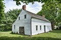 view gallery view galleryW11.7 km |  Graham--Brush Log House - Pine Plains NY Graham--Brush Log House - Pine Plains NY
in U.S. National Register of Historic Places Graham-Brush Log House was built in about 1776 and is a two-room log structure with a wood frame lean-to on its rear elevation. The Brush house was acquired in 1997-1998 by the local historical society, the Little Nine Partners Historical Society. posted by: nomadwillie location: New York date approved: 03/03/2023 last visited: never |
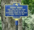 view gallery view galleryW11.7 km | Brush House in New York Historical Markers Graham-Brush Log House was built in about 1776 and is a two-room log structure with a wood frame lean-to on its rear elevation. posted by: nomadwillie location: New York date approved: 03/08/2023 last visited: never |
|