 view gallery view gallery W8.5 km W8.5 km
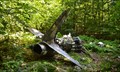
|   Van Wyck Mountain T-33 Crash Site Van Wyck Mountain T-33 Crash Site
in Plane Crash Sites The wreckage of a T-33 military trainer on the southern ridge of Van Wyck mountain in the Catskills. posted by:  M.Bahlam M.Bahlam location: New York date approved: 01/03/2015 last visited: never |
 view gallery view gallery E11.3 km E11.3 km
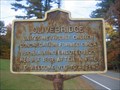
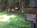
|  Olivebridge Olivebridge
in New York Historical Markers Olivebridge NY Historical Marker located on Rt. 213 in Olivebridge posted by:  Team Smokey Team Smokey location: New York date approved: 11/01/2008 last visited: never |
 view gallery view gallery NW11.3 km NW11.3 km
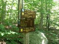
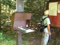
|  Eastern Terminus - Finger Lakes Trail - New York Eastern Terminus - Finger Lakes Trail - New York
in Long Distance Hiking Trails This is a very significant coordinate for those who are attempting to earn credit for End-to-end status on the Finger Lakes Trails, as it is the easternmost end, and the hardest to get to, much less hike. posted by: sagefemme location: New York date approved: 08/20/2014 last visited: never |
 view gallery view gallery N11.6 km N11.6 km
|  Highest Point in Ulster County (New York State) Highest Point in Ulster County (New York State)
in Geographic High Points Slide Mountain is the highest point in Ulster County. posted by: weathernowcast location: New York date approved: 07/15/2010 last visited: 12/03/2016 |
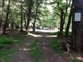
 view gallery view galleryNW12.9 km | Phonicia-East Branch Trailhead - Denning, NY in Trail Registers The first 1.2 miles of this trail is also the last 1.2 miles of the Finger Lakes Trail. At that point it intersects with the Peekamoose-Table Trail. The Phonicia-East Branch Trail continues to the left and intersects with Curtis-Ormsbee Trail. posted by: sagefemme location: New York date approved: 09/01/2014 last visited: never |
 view gallery view galleryNW12.9 km |  Phonicia-East Branch (Denning) Trail - Catskills, NY Phonicia-East Branch (Denning) Trail - Catskills, NY
in Hiking and walking trailheads See notes on trail register waymark... This trail ultimately, can take you far. posted by: sagefemme location: New York date approved: 08/24/2014 last visited: never |
 view gallery view galleryNW12.9 km |  Dennning Rd DEC primitive campsite Dennning Rd DEC primitive campsite
in Free Campsites This site just off Denning Road has direct access to the East Branch Neversink River. posted by: sagefemme location: New York date approved: 08/20/2014 last visited: never |
 view gallery view gallery NE13 km NE13 km
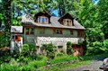
|  Brunel, Emile, Studio and Sculpture Garden - Boiceville, NY Brunel, Emile, Studio and Sculpture Garden - Boiceville, NY
in U.S. National Register of Historic Places The Emile Brunel Sculpture Garden and Studio, also known as the Totem Indian Trading Post, Le Chalet Indien, and Brunel Park, is located on Da Silva Road, just off the NY 28 state highway, in Boiceville, Town of Olive, New York, United States. posted by: nomadwillie location: New York date approved: 06/18/2013 last visited: never |
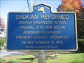 view gallery view galleryNE13 km | Shokan Reformed in New York Historical Markers Shokan Reformed NY Historical Marker located on Rt. 28 in Shokan. posted by: Team Smokey location: New York date approved: 11/04/2008 last visited: never |
 view gallery view gallery SE13.7 km SE13.7 km
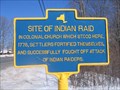
| Site of Indian Raid in New York Historical Markers Site of Indian Raid NY Historical Marker located on Route 209 in Kerhonkson. posted by: Team Smokey location: New York date approved: 03/04/2008 last visited: 05/27/2000 |
 view gallery view gallery S13.7 km S13.7 km
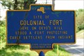
| Site of Colonial Fort in New York Historical Markers Site of Colonial Fort NY Historical Marker located on Route 209 in Kerhonkson posted by: Team Smokey location: New York date approved: 03/04/2008 last visited: 05/13/2009 |
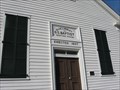
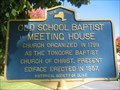 view gallery view galleryNE13.8 km | Old School Baptist Meeting House in New York Historical Markers Old School Baptist Meeting House NY Historical Marker located on Rt. 28 in Olive posted by: Team Smokey location: New York date approved: 11/04/2008 last visited: 03/19/2010 |
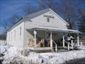
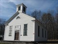 view gallery view galleryNE13.8 km | Olive and Hurley Old School Baptist Church - Shokan , NY in U.S. National Register of Historic Places Founded in 1799 as the Tongore Baptist Church, this is the oldest Baptist congregation in Ulster County. The current building was erected in 1857 posted by:  briansnat briansnat location: New York date approved: 03/23/2010 last visited: never |
 view gallery view galleryNE13.8 km |  Olive and Hurley Old School Baptist Church Olive and Hurley Old School Baptist Church
in Wikipedia Entries The congregation was organized in 1799 as the Tongore Baptist Church of Christ. The current building was erected in 1857. It was the first Baptist church in Ulster county and eventually came to be known as Olive & Hurley Old School Baptist Church. posted by: briansnat location: New York date approved: 03/30/2010 last visited: never |
 view gallery view galleryNE13.8 km |  Olive and Hurley Old School Baptist Church - Shokan, NY Olive and Hurley Old School Baptist Church - Shokan, NY
in This Old Church This church was organized in 1799 as the Tongore Baptist Church of Christ. The current building was erected in 1857. posted by: briansnat location: New York date approved: 03/21/2010 last visited: never |
 view gallery view galleryS14.3 km |  Kerhonkson, NY 12446 Kerhonkson, NY 12446
in U.S. Post Offices Kerhonkson, NY 12446 US Post Office posted by: Team Smokey location: New York date approved: 03/08/2008 last visited: 03/19/2009 |
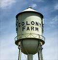 view gallery view galleryS14.3 km |  Colony Farm - Kerhonkson, NY Colony Farm - Kerhonkson, NY
in Named Farms and Ranches Colony Farm is a former state prison dairy farm in the Catskill-Shawangunk Greenway. posted by: nomadwillie location: New York date approved: 04/26/2022 last visited: never |
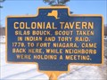 view gallery view gallerySE14.5 km | Colonial Tavern in New York Historical Markers Colonial Tavern NY Historical Marker located on Route 209 in Mill Hook posted by: Team Smokey location: New York date approved: 03/04/2008 last visited: never |
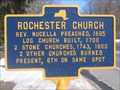 view gallery view gallerySE14.6 km | Rochester Church in New York Historical Markers Rochester Church NY Historical Marker located on Route 209 in Accord posted by: Team Smokey location: New York date approved: 03/04/2008 last visited: never |
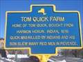 view gallery view gallerySE14.6 km | Tom Quick Farm in New York Historical Markers Tom Quick Farm NY Historical Marker located on Route 209 in Accord posted by: Team Smokey location: New York date approved: 03/04/2008 last visited: never |
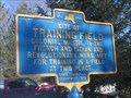 view gallery view gallerySE15.3 km | Site of Training Field in New York Historical Markers Site of Training Field NY Historical Marker located on Route 209 in Accord posted by: Team Smokey location: New York date approved: 03/04/2008 last visited: never |
 view gallery view gallerySE15.3 km |  Town of Rochester Public School, Accord, NY, USA Town of Rochester Public School, Accord, NY, USA
in Former Schools Town of Rochester Public School, Accord, NY, USA posted by: Team Smokey location: New York date approved: 03/09/2008 last visited: never |
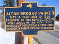 view gallery view gallerySE15.4 km | Alton Brooks Parker in New York Historical Markers Alton Brooks Parker NY Historical Marker located on Route 209 in Accord posted by: Team Smokey location: New York date approved: 03/04/2008 last visited: never |
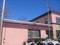 view gallery view gallerySE15.8 km | Accord, NY 12404 in U.S. Post Offices Accord, NY 12404 US Post Office posted by: Team Smokey location: New York date approved: 03/08/2008 last visited: never |
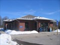
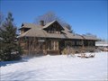 view gallery view gallerySE15.8 km |  Accord Train Station Accord Train Station
in Train Stations/Depots Accord Train Station located on Main Street in Accord, NY. posted by: Team Smokey location: New York date approved: 03/10/2008 last visited: never |
|