 view gallery view gallery NE19 km NE19 km
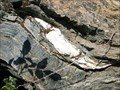
|   Serpentinite of The Rattlesnake Terrain Serpentinite of The Rattlesnake Terrain
in Places of Geologic Significance The Rattlesnake Terrain is a mash of gabbro, chert, granite, and sandstone within serpentite that was added to the North American Plate in the Late Jurrasic during an accretionary episode. posted by:  TerryDad2 TerryDad2 location: California date approved: 01/03/2010 last visited: 07/09/2010 |
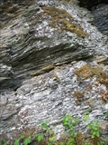 view gallery view gallery E41.2 km E41.2 km
| Condrey Mountain Schist Type Section in Places of Geologic Significance A type section is an exposure of rock that is used as the standard by which other exposures of the same rock are compared. The Condrey Mountain Schist is a metamorphic rock that is found throughout the Klamath Mountains. posted by: TerryDad2 location: California date approved: 01/03/2010 last visited: never |
 view gallery view gallery SE41.8 km SE41.8 km
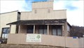
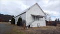
|  Valley Oaks Senior Center - Greenview, CA Valley Oaks Senior Center - Greenview, CA
in Municipal Community Centers This senior center advertises bingo on Monday night. posted by: NW_history_buff location: California date approved: 11/20/2017 last visited: never |
 view gallery view gallerySE41.8 km |  Scott Valley Fire District Scott Valley Fire District
in Firehouses A volunteer fire department located in the tiny community of Greenview. posted by: NW_history_buff location: California date approved: 11/21/2017 last visited: never |
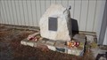 view gallery view gallerySE41.8 km |  Greenview Volunteer Fire Department - Greenview, CA Greenview Volunteer Fire Department - Greenview, CA
in Firefighter Memorials A plaque dedication resides in front of the Scott Valley Fire District building. posted by: NW_history_buff location: California date approved: 11/20/2017 last visited: never |
 view gallery view gallerySE41.8 km |  Scott Valley Grange #386 - Greenview, CA Scott Valley Grange #386 - Greenview, CA
in Grange Halls An active grange hall in Greenview. posted by: NW_history_buff location: California date approved: 11/20/2017 last visited: never |
 view gallery view gallerySE42 km |  Greenview, CA 96037 Greenview, CA 96037
in U.S. Post Offices Greenview's post office. posted by: NW_history_buff location: California date approved: 11/24/2017 last visited: never |
 view gallery view gallery NW42.5 km NW42.5 km
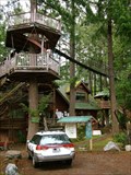
|  Out 'n' About Treesort and Treehouse Institute Out 'n' About Treesort and Treehouse Institute
in Treehouses A group of 10 treehouses that are rented out as a treehouse bread and breakfast in Takilma Oregon. posted by: GeoHueb location: Oregon date approved: 06/28/2008 last visited: never |
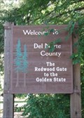 view gallery view galleryNW42.8 km |  The Redwood Gate to the Golden State - Del Norte County, CA The Redwood Gate to the Golden State - Del Norte County, CA
in Welcome Signs This sign is seen entering Del Norte County from the northeast on Highway 199, the Redwood Highway, that connects Grants Pass, Oregon, to the Crescent City, California, on the Pacific Coast. posted by:  silverquill silverquill location: California date approved: 02/18/2009 last visited: 08/29/2013 |
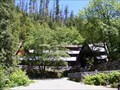
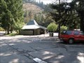 view gallery view galleryNW43 km |  Collier Tunnel Safety Rest Area - U.S. Hwy. 199 Collier Tunnel Safety Rest Area - U.S. Hwy. 199
in Highway Rest Areas U.S. Hwy. 199 rest area between Crescent City, CA and Cave Junction, OR. posted by: Volcanoguy location: California date approved: 01/08/2013 last visited: 09/25/2012 |
 view gallery view gallery N43.5 km N43.5 km
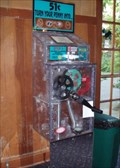
|  Penny Smasher - Oregon Caves National Monument Penny Smasher - Oregon Caves National Monument
in Penny Smashers This penny smasher is located in the Chalet at Oregon Caves National Monument. Three designs are of the Oregon Caves, and a fourth is an inverted horseshoe design. The Chalet has housing, restaurants and a gift shop. posted by: silverquill location: Oregon date approved: 02/17/2009 last visited: 08/01/2012 |
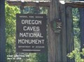
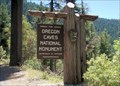
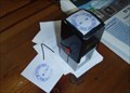 view gallery view galleryN43.5 km |  Oregon Caves National Monument Oregon Caves National Monument
in NPS Passport Cancellation Stations Discovered in 1874 by Elijah Davidson, the Oregon Caves became a National Park in 1903. Besides the network of caves, there are many recreational opportunities on the surface. This stamping station is at the main visitor center. posted by: silverquill location: Oregon date approved: 02/17/2009 last visited: 05/29/2022 |
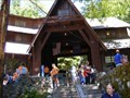
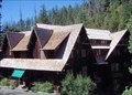 view gallery view galleryN43.5 km |  Oregon Caves Chateau - Cave Junction, OR Oregon Caves Chateau - Cave Junction, OR
in U.S. National Register of Historic Places Discovered in 1874 by Elijah Davidson, the Oregon Caves became a National Park in 1903. The Chateau was built in 1929 and is now considered to be one of the best preserved rustic lodges in the National Park System. posted by: silverquill location: Oregon date approved: 02/18/2009 last visited: 05/29/2022 |
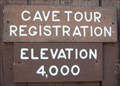 view gallery view galleryN43.5 km |  Oregon Caves National Monument 4,000 feet Oregon Caves National Monument 4,000 feet
in Elevation Signs The elevation sign at the main visitor center at Oregon Caves National Monument reads 4,000 feet. The entrance to the caves is nearby. posted by: silverquill location: Oregon date approved: 02/17/2009 last visited: 08/07/2015 |
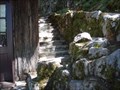
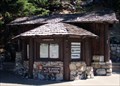 view gallery view galleryN43.5 km |  Checking & Comfort Station, Oregon Caves Historic District - Cave Junction, OR Checking & Comfort Station, Oregon Caves Historic District - Cave Junction, OR
in NRHP Historic Districts - Contributing Buildings The Checking and Comfort Station was built in 1941. It is a wood frame building with cedar-bark sheathing near the monument’s day-use parking area. Rustic stone masonry was added to the north side of the building in the 1960s. posted by: silverquill location: Oregon date approved: 02/17/2009 last visited: 05/29/2022 |
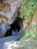 view gallery view galleryN43.5 km | ") Oregon Caves National Monument Oregon Caves National Monument
in Cave Entrances (Natural) Discovered in 1874 by Elijah Davidson, the Oregon Caves became a National Park in 1903. This is actually most used as an exit for guided tours. The original entrance has been blocked. The entire cave is about 3 1/2 miles long. posted by: silverquill location: Oregon date approved: 02/17/2009 last visited: 05/29/2022 |
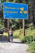 view gallery view galleryNW43.5 km |  Welcome To California Ca/Or Border on US199 Welcome To California Ca/Or Border on US199
in Border Crossings The California welcome sign about .1 mile south of the OR/CA border on US highway 199 Between Grants Pass, Oregon and Crescent City, California. posted by: HeyRob4449 location: California date approved: 10/20/2007 last visited: 09/23/2012 |
 view gallery view galleryN43.5 km |  Oregon Caves National Monument and Preserve - Cave Junction OR Oregon Caves National Monument and Preserve - Cave Junction OR
in Wikipedia Entries Oregon Caves National Monument and Preserve is a protected area in the northern Siskiyou Mountains of southwestern Oregon in the United States. The 4,554-acre (1,843 ha) park includes the marble cave. posted by: Don.Morfe location: Oregon date approved: 05/29/2022 last visited: 05/29/2022 |
 view gallery view galleryN43.5 km |  Oregon Caves National Monument and Preserve - Cave Junction OR Oregon Caves National Monument and Preserve - Cave Junction OR
in National Parks of the World Oregon Caves National Monument and Preserve is a protected area in the northern Siskiyou Mountains of southwestern Oregon in the United States. The 4,554-acre (1,843 ha) park includes the marble cave. posted by: Don.Morfe location: Oregon date approved: 05/30/2022 last visited: 05/29/2022 |
 view gallery view galleryN43.5 km |  Oregon Caves National Monument and Preserve - Cave Junction OR Oregon Caves National Monument and Preserve - Cave Junction OR
in Official Local Tourism Attractions Oregon Caves National Monument and Preserve is a protected area in the northern Siskiyou Mountains of southwestern Oregon in the United States. The 4,554-acre (1,843 ha) park includes the marble cave. posted by: Don.Morfe location: Oregon date approved: 05/29/2022 last visited: 05/29/2022 |
 view gallery view galleryN43.5 km |  Ranger Station at Oregon Caves National Monument and Preserve - Cave Junction OR Ranger Station at Oregon Caves National Monument and Preserve - Cave Junction OR
in Ranger Stations The Ranger Station is inside the Visitor Center at Oregon Caves National Monument. This is where you can get a NPS Cancellation Stamp. posted by: Don.Morfe location: Oregon date approved: 06/11/2022 last visited: 05/29/2022 |
 view gallery view galleryN43.5 km |  Oregon Caves Chateau - Cave Junction OR Oregon Caves Chateau - Cave Junction OR
in Satellite Imagery Oddities The Oregon Caves Chateau is a historic American hotel that opened in 1934. It is located in Oregon Caves National Monument in southern Oregon, near Cave Junction. posted by: Don.Morfe location: Oregon date approved: 05/29/2022 last visited: 05/29/2022 |
 view gallery view galleryN43.5 km | Oregon Caves National Monument and Preserve - Cave Junction OR in Satellite Imagery Oddities Oregon Caves National Monument and Preserve is a protected area in the northern Siskiyou Mountains of southwestern Oregon in the United States. The 4,554-acre (1,843 ha) park includes the marble cave. posted by: Don.Morfe location: Oregon date approved: 05/29/2022 last visited: 05/29/2022 |
 view gallery view galleryN43.6 km | ") Oregon Caves National Monument Oregon Caves National Monument
in National Parks (U.S.) Discovered in 1874 by Elijah Davidson, the Oregon Caves became a National Park in 1903. Besides the network of caves, there are many recreational opportunities on the surface. The park has several historic buildings as well. posted by: silverquill location: Oregon date approved: 02/19/2009 last visited: 05/29/2022 |
 view gallery view galleryN43.6 km | Oregon Caves Historic District - Cave Junction, OR in U.S. National Register of Historic Places Discovered in 1874 by Elijah Davidson, the Oregon Caves became a National Park in 1903. The district has four historic buildings near the entrance to the caves. posted by: silverquill location: Oregon date approved: 02/18/2009 last visited: 05/29/2022 |
|