 view gallery view gallery N0.3 km N0.3 km
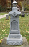
|   Hunt - Hartsgrove Twp Cemetery - Hartsgrove, Ohio Hunt - Hartsgrove Twp Cemetery - Hartsgrove, Ohio
in Zinc Headstones Zinc marker for Seymour M. Hunt posted by:  lp5324 lp5324 location: Ohio date approved: 11/02/2008 last visited: never |
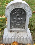 view gallery view galleryN0.3 km | Rice - Hartsgrove Cemetery - Hartsgrove, Ohio in Zinc Headstones Zinc marker for Louisa M. Rice posted by: lp5324 location: Ohio date approved: 11/02/2008 last visited: never |
 view gallery view gallery S5.5 km S5.5 km
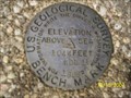
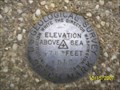
|  USGS Benchmark - WDL 15 - Windsor, OH USGS Benchmark - WDL 15 - Windsor, OH
in U.S. Benchmarks USGS Benchmark WDL 15 (1044 FT) in Windsor, OH at the intersection of Plank Rd.(SR-86) and Stoneville Rd.(Cr-535). posted by: Team rbass location: Ohio date approved: 10/24/2007 last visited: never |
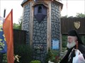 view gallery view galleryN6.9 km |  Great Lakes Medieval Faire Great Lakes Medieval Faire
in Renaissance Fairs The Faire village of Avaloch posted by:  Captain Chaoss Captain Chaoss location: Ohio date approved: 08/24/2008 last visited: 08/12/2012 |
 view gallery view gallery E7.2 km E7.2 km
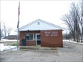
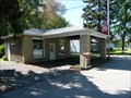
|  Rome, OH 44085 Rome, OH 44085
in U.S. Post Offices This is a small stand alone post office in the crossroads town of Rome, Ohio in northeast Ohio. posted by: miatabug location: Ohio date approved: 03/16/2008 last visited: 12/16/2018 |
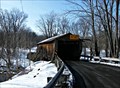
 view gallery view galleryS8 km |  Warner Hollow (35-04-25) - Ashtabula County, Ohio Warner Hollow (35-04-25) - Ashtabula County, Ohio
in Covered Bridges Warner Hollow Covered Bridge (35-04-25) over Phelps Creek on Wiswell Rd (TR 533) in Ashtabula County, Ohio. posted by: buffalohiker location: Ohio date approved: 03/09/2011 last visited: 08/13/2009 |
 view gallery view gallery NE8 km NE8 km
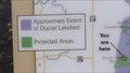
|  Morgan Swamp Preserve Morgan Swamp Preserve
in 'You Are Here' Maps This You Are Here sign is at the viewing platform of the Morgan Swamp Nature Preserve in Ashtabula County Ohio. posted by: miatabug location: Ohio date approved: 02/06/2012 last visited: 12/16/2018 |
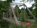 view gallery view galleryNE9.5 km |  Stiles Ave Pratt through truss bridge - Ashtabula Co, Ohio Stiles Ave Pratt through truss bridge - Ashtabula Co, Ohio
in Truss Bridges Stiles Ave Pratt through truss bridge over Rock Creek in Ashtabula County, Ohio posted by: buffalohiker location: Ohio date approved: 06/02/2012 last visited: 12/31/2018 |
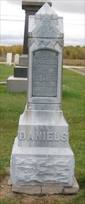 view gallery view galleryN9.7 km | Daniels/Exceen - Trumbull Cemetery - Trumbull, Ohio in Zinc Headstones Zinc marker for Nelson, Elizabeth and Lucy Daniels and John and Lucinda Exceen. posted by: lp5324 location: Ohio date approved: 11/02/2008 last visited: 03/02/2012 |
 view gallery view gallery W10.1 km W10.1 km
|  Observatory Park - 1254 Feet - Montville, Ohio Observatory Park - 1254 Feet - Montville, Ohio
in Elevation Signs Observatory Park is a part of the Geauga Park District in northeast Ohio. posted by: miatabug location: Ohio date approved: 02/12/2012 last visited: 09/20/2015 |
 view gallery view galleryW10.1 km |  N 41 34.991 W 081 04.295 - Observatory Park - Montville, Ohio N 41 34.991 W 081 04.295 - Observatory Park - Montville, Ohio
in Permanent Geographic Coordinates This sign is placed at the entrance to the drive for Geauga Park's Observatory Park. posted by: miatabug location: Ohio date approved: 02/06/2012 last visited: 09/20/2015 |
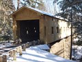
 view gallery view galleryNE10.1 km | Riverdale Road Covered Bridge USGS B.M. in U.S. Benchmarks At the West end of a 114 foot Town Lattice bridge on the South side of the road, near a drain pipe and not far from the Grand River.
Sits on property that is mowed and is in very good condition. posted by: Team rbass location: Ohio date approved: 10/21/2007 last visited: 05/03/2014 |
 view gallery view galleryNE10.1 km | Riverdale Bridge - Morgan Township Ohio in Covered Bridges This 140 foot bridge spans the Grand River in Ashtabula, Ohio. posted by: miatabug location: Ohio date approved: 03/16/2010 last visited: 08/13/2009 |
 view gallery view gallery SE10.5 km SE10.5 km
|  Orwell, Ohio law office Orwell, Ohio law office
in Vintage Gas Stations This vintage gas station that now serves as a law office. posted by: miatabug location: Ohio date approved: 08/29/2008 last visited: never |
 view gallery view gallerySE10.5 km |  A&W Restaurant Orwell A&W Restaurant Orwell
in A + W Restaurants A & W Restaurant Orwell, OH posted by: BeckyLee location: Ohio date approved: 09/12/2011 last visited: 12/16/2018 |
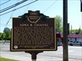 view gallery view gallerySE10.6 km |  Adna R. Chaffee (9-4) Adna R. Chaffee (9-4)
in Ohio Historical Markers This marker in Orwell, Ohio celebrates the life of a local man who became the Chief of Staff of the U.S. Army posted by: miatabug location: Ohio date approved: 08/29/2008 last visited: 09/20/2015 |
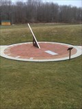 view gallery view galleryW10.8 km |  Observatory Park Sundial, Montville Twp, Ohio, USA Observatory Park Sundial, Montville Twp, Ohio, USA
in Sundials Sundial in the new Geauga Park District's Observatory Park. posted by: JoelMart location: Ohio date approved: 03/09/2012 last visited: 09/20/2015 |
 view gallery view galleryW10.8 km |  Compass Rose - Observatory Park, Montville Twp, Ohio Compass Rose - Observatory Park, Montville Twp, Ohio
in Compass Roses Compass Rose in the new Geauga Park District's Observatory Park. posted by: JoelMart location: Ohio date approved: 03/11/2012 last visited: 09/20/2015 |
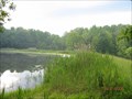 view gallery view galleryNE11.1 km |  Cub World Lake, Rock Creek, Ohio Cub World Lake, Rock Creek, Ohio
in Water Dams Beaumont Scout Reservation posted by: Team RAGAR location: Ohio date approved: 06/23/2008 last visited: 08/07/2011 |
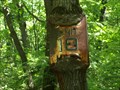 view gallery view gallery NW12.1 km NW12.1 km
|  Sign Eating Tree - Thompson Ledges Park, Thompson, Ohio Sign Eating Tree - Thompson Ledges Park, Thompson, Ohio
in Omnivorous Trees This sign eating tree is found in Thompson Ledges Park, Thompson, (Geauga County) Ohio. posted by: buffalohiker location: Ohio date approved: 06/04/2012 last visited: 09/13/2015 |
 view gallery view gallery SW12.1 km SW12.1 km
|  Corner Field Model Railroad Museum Corner Field Model Railroad Museum
in Model Railroads Corner Field Model Railroad Museum and Hobby has the largest family owned 3-rail layout in Ohio. It has over a thousand buildings, over 2,800 feet of track, and hundreds of freight cars. posted by: buffalohiker location: Ohio date approved: 08/18/2023 last visited: 03/04/2023 |
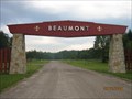 view gallery view galleryNE12.1 km |  Beaumont Scout Reservation GCC BSA Beaumont Scout Reservation GCC BSA
in Boy Scout Camps Greater Cleveland Council of Ohio, USA posted by: Team RAGAR location: Ohio date approved: 06/29/2008 last visited: 12/16/2018 |
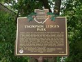 view gallery view galleryNW12.2 km | Thompson Ledges Park (6-28) in Ohio Historical Markers Two-sided historical marker showing one of Geauga County's oldest parks on one side and the geologic feature that helped create the park on the other. posted by: miatabug location: Ohio date approved: 07/07/2007 last visited: 12/16/2018 |
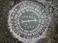 view gallery view gallerySE12.4 km |  ORWELL AZ MK - Ohio ORWELL AZ MK - Ohio
in Azimuth Benchmarks This is the azimuth mark for station ORWELL, in Orwell Township, Ashtabula County. posted by: shorbird location: Ohio date approved: 05/22/2009 last visited: 04/16/2010 |
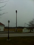 view gallery view galleryNW12.4 km |  Fire Rescue Siren - Thompson, OH Fire Rescue Siren - Thompson, OH
in Outdoor Warning Sirens Thompson Fire Recue Siren in Thompson, OH. posted by: JoelMart location: Ohio date approved: 03/10/2012 last visited: 09/13/2015 |
|