 view gallery view gallery SE15.4 km SE15.4 km
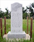
|   Deadwood Trail Marker, near Chugwater, WY Deadwood Trail Marker, near Chugwater, WY
in Wyoming Historical Markers This marks a stage station on the route between Cheyenne and Fort Laramie, and the route north to Montana and Dakota Territory posted by:  ronjean ronjean location: Wyoming date approved: 07/28/2011 last visited: 12/15/2014 |
 view gallery view gallery NE25.3 km NE25.3 km
|  Watchful Cowboy, Chugwater, WY Watchful Cowboy, Chugwater, WY
in Silhouette Public Art Sculptures This horse and rider look over the traffic on the Interstate hiway. posted by: ronjean location: Wyoming date approved: 02/25/2011 last visited: 09/07/2018 |
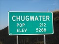
 view gallery view galleryNE28.6 km |  Chugwater, WY - Population 212 Chugwater, WY - Population 212
in Population Signs Chugwater, WY, population 212 as of this posting. This sign is located on the south side of I-25B/WY 321 at the west end of town. posted by:  QuarrellaDeVil QuarrellaDeVil location: Wyoming date approved: 10/04/2015 last visited: 05/25/2020 |
 view gallery view galleryNE28.8 km |  Chugwater, WY - Elevation 5288 Chugwater, WY - Elevation 5288
in Elevation Signs Chugwater, WY is at 5288 feet above sea level. posted by: QuarrellaDeVil location: Wyoming date approved: 09/29/2015 last visited: 05/25/2020 |
 view gallery view galleryNE28.8 km |  Chugwater Rock Outcroppings - Chugwater, WY Chugwater Rock Outcroppings - Chugwater, WY
in Flora and Fauna Information Signs A Wyoming's Wildlife sign at the rest area on the east side of I 25, within a minute's drive from Chugwater, provides some background about the wildlife you'll see in the area. posted by: QuarrellaDeVil location: Wyoming date approved: 05/29/2020 last visited: never |
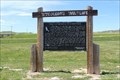 view gallery view galleryNE28.8 km | Chugwater Rock Outcroppings - Chugwater, WY in Wyoming Historical Markers A Wyoming's Wildlife marker at the rest area on the east side of I 25, within a minute's drive from Chugwater, provides some background about the wildlife you'll see in the area. posted by: QuarrellaDeVil location: Wyoming date approved: 05/26/2020 last visited: never |
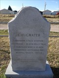 view gallery view galleryNE29 km | Chugwater in Wyoming Historical Markers A small, granite marker stands along the main route through Chugwater, WY, providing a small sound byte of information about its time as a stagecoach stop. posted by: QuarrellaDeVil location: Wyoming date approved: 09/27/2015 last visited: 09/29/2021 |
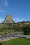 view gallery view gallery E30.3 km E30.3 km
|  Entrance Road--Devils Tower National Monument - Devil's Tower, WY Entrance Road--Devils Tower National Monument - Devil's Tower, WY
in U.S. National Register of Historic Places The CCC built this road in 1935 to improve the existing 8% grade dirt road that was used to access the Monument. posted by: Hikenutty location: Wyoming date approved: 07/16/2007 last visited: 09/19/2023 |
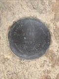
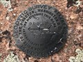
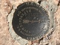
 view gallery view gallery NW33.5 km NW33.5 km
|  P 166 RESET (AH7389) - Platte County, Wyoming P 166 RESET (AH7389) - Platte County, Wyoming
in U.S. Benchmarks An NGS vertical control disk on the northwest side of State Highway 34. posted by: Tom.dog location: Wyoming date approved: 06/11/2023 last visited: never |
 view gallery view gallery N36.4 km N36.4 km
| N 166 RESET (MO1339) - Platte County, Wyoming in U.S. Benchmarks An NGS vertical control mark on the west side of State Highway 34. posted by: Tom.dog location: Wyoming date approved: 12/09/2022 last visited: never |
 view gallery view galleryNW38 km | ALBW 38 - Albany County, Wyoming in U.S. Benchmarks A Wyoming Highway Department survey marker near an abandoned section of highway grade. posted by: Tom.dog location: Wyoming date approved: 08/13/2023 last visited: never |
 view gallery view galleryN38.5 km | 10 WWC (MO0374) - Platte County, Wyoming in U.S. Benchmarks This USGS benchmark can be found a short ways to the north of State Highway 34. posted by: Tom.dog location: Wyoming date approved: 12/09/2022 last visited: never |
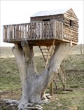 view gallery view galleryN38.6 km |  Wyoming Treehouse, Wheatland, WY Wyoming Treehouse, Wheatland, WY
in Treehouses This house is visible from northbound Interstate 25, an hour north of Cheyenne. posted by: ronjean location: Wyoming date approved: 04/26/2011 last visited: 11/14/2020 |
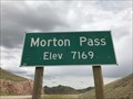 view gallery view gallery W40.4 km W40.4 km
| Morton Pass, Albany County, Wyoming - 7,169' in Elevation Signs The summit of Morton Pass is marked by two signs on either side of State Highway 34 that display the elevation of the pass. posted by: Tom.dog location: Wyoming date approved: 08/11/2023 last visited: never |
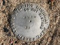
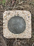
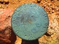
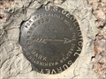
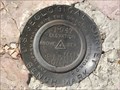
 view gallery view gallery SW42.3 km SW42.3 km
| RUSSELL RM 1 (MO1221) - Albany County, Wyoming in U.S. Benchmarks Reference mark 1 for triangulation station RUSSELL (MO1220). posted by: Tom.dog location: Wyoming date approved: 06/25/2023 last visited: never |
 view gallery view gallerySW42.3 km | RUSSELL (MO1220) - Albany County, Wyoming in U.S. Benchmarks This is a 1912 triangulation station on top of a granite knob in the Pole Mountain unit of Medicine Bow National Forest. posted by: Tom.dog location: Wyoming date approved: 06/25/2023 last visited: never |
 view gallery view gallerySW42.3 km | RUSSELL NO 2 - Albany County, Wyoming in U.S. Benchmarks Reference mark 2 for triangulation station RUSSELL (MO1220). posted by: Tom.dog location: Wyoming date approved: 06/25/2023 last visited: never |
 view gallery view gallerySW43.1 km | 8287 DENVER (AA2129) - Albany County, Wyoming in U.S. Benchmarks A USGS pipe cap to the southeast of Forest Service Road 712 (Telephone Road). posted by: Tom.dog location: Wyoming date approved: 11/21/2022 last visited: never |
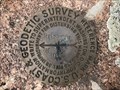
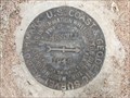
 view gallery view gallerySW43.3 km | PILOT NO 1 - Albany County, Wyoming in U.S. Benchmarks The U.S. Coast & Geodetic Survey's reference mark 1 for the USGS's PILOT 2 benchmark. posted by: Tom.dog location: Wyoming date approved: 07/31/2023 last visited: never |
 view gallery view gallerySW43.3 km | PILOT NO 2 NO 2 - Albany County, Wyoming in U.S. Benchmarks Reference mark 2 for USGS benchmark PILOT 2. posted by: Tom.dog location: Wyoming date approved: 07/31/2023 last visited: never |
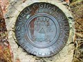
 view gallery view gallerySW43.3 km | PILOT 2 (MO1246) - Albany County, Wyoming in U.S. Benchmarks This USGS benchmark is located atop Pilot Hill, a local topographic landmark that rises to the east of the city of Laramie. posted by: Tom.dog location: Wyoming date approved: 07/31/2023 last visited: never |
 view gallery view gallerySW43.3 km | PILOT NO 2 NO 1 - Albany County, Wyoming in U.S. Benchmarks This is the USGS's reference mark 1 for PILOT 2 (not to be confused with the U.S. Coast & Geodetic Survey's reference mark 1 for the same benchmark). posted by: Tom.dog location: Wyoming date approved: 07/31/2023 last visited: never |
 view gallery view gallerySW43.3 km | RUSSELL Azimuth Mark - Albany County, Wyoming in U.S. Benchmarks This is the azimuth mark for triangulation station RUSSELL (MO1220). posted by: Tom.dog location: Wyoming date approved: 06/25/2023 last visited: never |
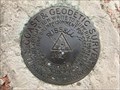
 view gallery view gallerySW43.3 km |  RUSSELL Azimuth Mark - Albany County, Wyoming RUSSELL Azimuth Mark - Albany County, Wyoming
in Azimuth Benchmarks The azimuth mark for triangulation station RUSSELL (MO1220). posted by: Tom.dog location: Wyoming date approved: 07/02/2023 last visited: never |
 view gallery view gallerySW43.8 km | BGRS 1 (MO1247) - Albany County, Wyoming in U.S. Benchmarks A USGS benchmark on the south side of Forest Service Road 712 (Telephone Road). posted by: Tom.dog location: Wyoming date approved: 11/21/2022 last visited: never |
|