 view gallery view gallery NE10.5 km NE10.5 km
|   18 JFM - Carbon County, Wyoming 18 JFM - Carbon County, Wyoming
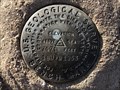
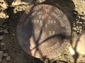
in U.S. Benchmarks A USGS benchmark on the west side of Cooper Cove Road. posted by:  Tom.dog Tom.dog location: Wyoming date approved: 01/08/2023 last visited: never |
 view gallery view gallery N16.7 km N16.7 km
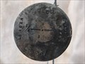
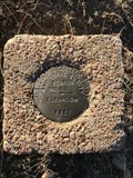
|  T19N R77W S8 S17 1/4 - Carbon and Albany Counties, Wyoming T19N R77W S8 S17 1/4 - Carbon and Albany Counties, Wyoming
in Public Land Survey Marks A privately monumented quarter corner marker on the boundary of Carbon County and Albany County. posted by: Tom.dog location: Wyoming date approved: 04/17/2023 last visited: never |
 view gallery view gallery S18.8 km S18.8 km
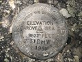
| 31 DHW - Albany County, Wyoming in U.S. Benchmarks This USGS benchmark is located near the intersection of State Highway 130 and Barber Lake Road. posted by: Tom.dog location: Wyoming date approved: 07/31/2023 last visited: never |
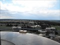
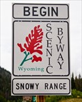 view gallery view galleryS19.5 km |  Snowy Range Scenic Byway - Centennial, WY Snowy Range Scenic Byway - Centennial, WY
in National Scenic Byways This 29 mile scenic byway cuts through the Medicine Bow National Forest from Laramie to the Upper Platte River Valley. posted by: IJAdventures location: Wyoming date approved: 09/11/2013 last visited: 07/24/2016 |
 view gallery view gallery NW20 km NW20 km
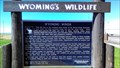
|  Wyoming Winds - Arlington, WY Wyoming Winds - Arlington, WY
in Flora and Fauna Information Signs This wildlife watching sign describes the importance of strong winds on the local habitat. posted by: IJAdventures location: Wyoming date approved: 07/23/2013 last visited: 01/25/2014 |
 view gallery view galleryNW20.1 km |  Wagonhound Rest Area - Arlington, WY Wagonhound Rest Area - Arlington, WY
in Wyoming Historical Markers This historical marker talks about the many travelers to cross this route from Native Americans to modern Interstate drivers. posted by: IJAdventures location: Wyoming date approved: 01/24/2014 last visited: 07/01/2016 |
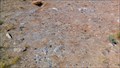 view gallery view galleryNW20.1 km |  Wagonhound Tipi Rings - Arlington, WY Wagonhound Tipi Rings - Arlington, WY
in New World Ancient Evidence These rings of stones were used by Native Americans to secure their teepees to the ground. posted by: IJAdventures location: Wyoming date approved: 07/23/2013 last visited: 07/24/2016 |
 view gallery view gallery SW20.3 km SW20.3 km
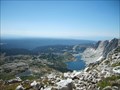
|  Medicine Bow Peak, Snowy Range - Wyoming Medicine Bow Peak, Snowy Range - Wyoming
in Mountain Summits The defining peak of the Laramie Valley, Medicine Bow is visible from Veedauwoo Pass on I-25, and as far north as Bosler on a clear day. posted by: Eagle1977 location: Wyoming date approved: 10/09/2012 last visited: never |
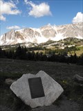
 view gallery view gallerySW20.8 km |  Snowy Range Vista at Libby Flats - Medicine Bow National Forest, WY Snowy Range Vista at Libby Flats - Medicine Bow National Forest, WY
in Scenic Overlooks A parking area complete with a view of Brown, Snowy and Sugar Loaf to one direction and Libby Flats and Colorado to the other. A little closer are some high alpine lakes and on the other side of the close ridge, Lake Marie and Mirror Lake. posted by: Eagle1977 location: Wyoming date approved: 01/12/2013 last visited: never |
 view gallery view gallerySW21.1 km |  Snowy Range/Medicine Bow - United Airlines 409 Snowy Range/Medicine Bow - United Airlines 409
in Plane Crash Sites Historical marker commemorating the crash of United Airlines Flight 409. posted by: Eagle1977 location: Wyoming date approved: 10/09/2012 last visited: 09/09/2013 |
 view gallery view galleryS21.6 km | N 101 (MP0057) - Albany County, Wyoming in U.S. Benchmarks This benchmark is located on the north side of the now-abandoned railway bed of the Coalmont Branch of the Union Pacific Railroad. posted by: Tom.dog location: Wyoming date approved: 11/21/2022 last visited: never |
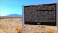
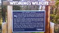 view gallery view gallerySW25.9 km | The Snowy Range - Medicine Bow National Forest, WY in Flora and Fauna Information Signs Lodgepole pine, quaking aspen, alpine tundra, wildflowers, pika, ptarmigan, elk and trout are some of the wildlife and flora you may find in the Snowy Range and read about on this sign. posted by: IJAdventures location: Wyoming date approved: 08/29/2013 last visited: never |
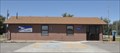 view gallery view galleryNE31.5 km |  Rock River, Wyoming 82083 Rock River, Wyoming 82083
in U.S. Post Offices This Post Office is located at 104 S 5th Street in Rock River, Wyoming. posted by: brwhiz location: Wyoming date approved: 10/31/2011 last visited: never |
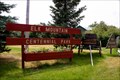 view gallery view galleryNW31.7 km |  Elk Mountain Centennial Park - Elk Mountain, WY Elk Mountain Centennial Park - Elk Mountain, WY
in Municipal Parks and Plazas This community park has all the small town charm you might expect. posted by: IJAdventures location: Wyoming date approved: 07/25/2013 last visited: never |
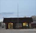 view gallery view galleryNW31.9 km | Elk Mountain, Wyoming 82324 in U.S. Post Offices This Post Office is located at 211 Bridge Street in Elk Mountain, Wyoming. posted by: brwhiz location: Wyoming date approved: 05/09/2012 last visited: 07/24/2013 |
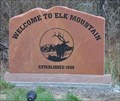 view gallery view galleryNW32.2 km |  Welcome to Elk Mountain Wyoming Welcome to Elk Mountain Wyoming
in Artistic Welcome Signs This welcome sign illustrates both the name of the town and signifcant local features of the area. posted by: brwhiz location: Wyoming date approved: 09/12/2012 last visited: 07/24/2013 |
 view gallery view galleryNW32.2 km |  Elk Mountain, Wyoming ~ Population 191 Elk Mountain, Wyoming ~ Population 191
in Population Signs This combination Elevation/Population sign is at the western town limits of Elk Mountain, Wyoming on Wyoming Highway 72. posted by: brwhiz location: Wyoming date approved: 09/07/2012 last visited: never |
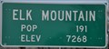 view gallery view galleryNW32.2 km |  Elk Mountain, Wyoming ~ Elevation 7268 Feet Elk Mountain, Wyoming ~ Elevation 7268 Feet
in Elevation Signs This combination Elevation/Population sign is at the western town limits of Elk Mountain, Wyoming on Wyoming Highway 72. posted by: brwhiz location: Wyoming date approved: 09/07/2012 last visited: never |
 view gallery view gallery SE32.2 km SE32.2 km
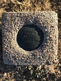
| T15N R76W S12 R75W S7 1/4 - Albany County, Wyoming in Public Land Survey Marks A USDI-Bureau of Land Management quarter corner marker on the west side of Big Hollow Road. posted by: Tom.dog location: Wyoming date approved: 12/23/2022 last visited: never |
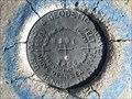
 view gallery view gallery E32.5 km E32.5 km
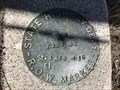
| STATION NO. 55 - Albany County, Wyoming in U.S. Benchmarks A destroyed U.S. Coast & Geodetic Survey and State Survey marker to the west of County Road 51. posted by: Tom.dog location: Wyoming date approved: 10/21/2022 last visited: never |
 view gallery view galleryE32.5 km | STATION NO. 64 - Albany County, Wyoming in U.S. Benchmarks A U.S. Coast & Geodetic Survey and State Survey marker on the west side of County Road 51. posted by: Tom.dog location: Wyoming date approved: 10/21/2022 last visited: never |
 view gallery view galleryNE32.5 km | Rock River, Wyoming ~ Population 235 in Population Signs This combination Elevation/Population sign is at the northern city limits of Rock River, Wyoming on US Highway 30/287 (4th Street). posted by: brwhiz location: Wyoming date approved: 09/25/2012 last visited: never |
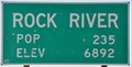 view gallery view galleryNE32.5 km | Rock River, Wyoming ~ Elevation 6892 in Elevation Signs This combination Elevation/Population sign is at the northern city limits of Rock River, Wyoming on US Highway 30/287 (4th Street). posted by: brwhiz location: Wyoming date approved: 09/24/2012 last visited: never |
 view gallery view galleryNE35.1 km | 7028' 52 St. 1316 + 16 - Albany County, Wyoming in U.S. Benchmarks This Wyoming State Highway Department marker is on the northeast side of U.S. Highway 287/30. posted by: Tom.dog location: Wyoming date approved: 04/17/2023 last visited: never |
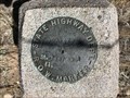 view gallery view galleryNE35.1 km | 7090 73 St. 1287 89.1 - Albany County, Wyoming in U.S. Benchmarks Wyoming State Highway Department Right-of-Way marker on the northeast side of U.S. 287/30. posted by: Tom.dog location: Wyoming date approved: 04/17/2023 last visited: never |
|