 view gallery view gallery W9.8 km W9.8 km
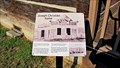
|   Joseph Christien Home - Pandosy Mission - Kelowna, BC Joseph Christien Home - Pandosy Mission - Kelowna, BC
in Signs of History This is a second history sign at the Christien Home, the previous being mounted on a wall of the porch, this one freestanding at a corner of the porch. posted by:  T0SHEA T0SHEA location: British Columbia, Canada date approved: 09/04/2014 last visited: never |
 view gallery view gallery SE14.5 km SE14.5 km
|  Burning Man Arts Festival Burning Man Arts Festival
in Festivals Counter-culture arts festival over Labor Day in the Black Rock Desert near Gerlach, NV. posted by: Squirreleen location: Nevada date approved: 04/24/2008 last visited: never |
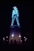 view gallery view gallerySE14.5 km |  Burning Man Burning Man
in Wikipedia Entries The Burning Man Arts Festival in Nevada posted by: Squirreleen location: Nevada date approved: 04/28/2008 last visited: 08/28/2008 |
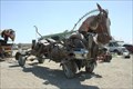 view gallery view gallerySE14.6 km |  Mutoid Waste Company--Metal Horse Mutoid Waste Company--Metal Horse
in Art Vehicles A giant metal horse pulling a stage wagon seen at Burning Man 2008. posted by: Squirreleen location: Nevada date approved: 09/27/2008 last visited: never |
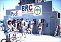 view gallery view gallerySE14.6 km |  Black Rock City, NV 89412 Black Rock City, NV 89412
in U.S. Post Offices Temporary post office of Black Rock City, NV posted by: Squirreleen location: Nevada date approved: 04/10/2008 last visited: 08/26/2007 |
 view gallery view gallery S22.5 km S22.5 km
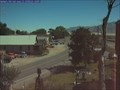
|  Downtown Gerlach Webcam Downtown Gerlach Webcam
in Web Cameras This webcam is owned by the BLM and is located in Gerlach, NV. It looks down at a small park and on towards Bruno's Resturant, Home of Bruno's World Famous Ravioli. posted by: 4wheeler location: Nevada date approved: 08/17/2005 last visited: 05/30/2021 |
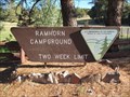 view gallery view galleryW77.7 km |  Ramhorn Springs Campground - CA Ramhorn Springs Campground - CA
in Campgrounds A small, off the beaten path campground north of Susanville, CA posted by: ChapterhouseInc location: California date approved: 06/30/2013 last visited: 06/28/2013 |
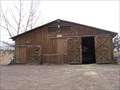 view gallery view galleryW79.3 km |  Spanish Springs Ranch Stable - Susanville, CA Spanish Springs Ranch Stable - Susanville, CA
in Barns Typical western style stable and tack barn located on this dude ranch in California cowboy country near Susanville. posted by:  fishingwishing fishingwishing location: California date approved: 12/28/2008 last visited: never |
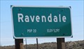
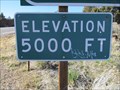 view gallery view galleryW80 km |  Highway 395 - Ravendale, CA - 5000' Highway 395 - Ravendale, CA - 5000'
in Elevation Signs The 5000' contour is marked near the rest area 12 miles south of Ravendale, California. posted by: WR7X location: California date approved: 03/21/2014 last visited: never |
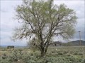 view gallery view galleryW84.5 km |  Shoe Tree - Ravendale, CA Shoe Tree - Ravendale, CA
in Shoe Trees Shoe tree just south of Ravendale, CA on Hwy 395 posted by: fishingwishing location: California date approved: 05/29/2008 last visited: 05/29/2011 |
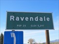 view gallery view galleryW85.5 km | Ravendale, CA (Southern Approach) - 5297' in Elevation Signs The sign is located at the southern approach to Ravendale on Highway 395. posted by: WR7X location: California date approved: 03/21/2014 last visited: never |
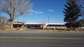 view gallery view galleryW85.6 km |  Ravendale Christian Church - Ravendale, CA Ravendale Christian Church - Ravendale, CA
in Religious Buildings Multifarious This community church was a former motel. posted by: NW_history_buff location: California date approved: 11/27/2016 last visited: never |
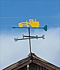 view gallery view galleryW85.6 km |  Road Grader Weathervane - Ravendale, CA Road Grader Weathervane - Ravendale, CA
in Unique Weathervanes This unique weathervane is located atop a work shed in Ravendale. posted by: NW_history_buff location: California date approved: 12/16/2016 last visited: never |
 view gallery view galleryW85.6 km | Ravendale, CA (Northern Approach) - 5297' in Elevation Signs The sign is located at the northern approach to Ravendale on Highway 395. posted by: WR7X location: California date approved: 03/21/2014 last visited: never |
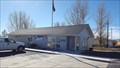 view gallery view galleryW85.6 km | Ravendale, CA 96123 in U.S. Post Offices This post office resides at the small community of Ravendale. posted by: NW_history_buff location: California date approved: 12/10/2016 last visited: never |
 view gallery view gallery NW92.4 km NW92.4 km
|  Vya, Nevada Vya, Nevada
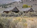
in Ghost Towns A small ghost town located in Washoe County, in northwestern Nevada. Not much remains of the town, which may have died in the 1920s, but two wooden buildings can still be seen--the Vya Post Office and School, reputedly run by a married couple. posted by: Nevada Desert Rat location: Nevada date approved: 06/10/2007 last visited: 06/25/2010 |
 view gallery view gallery SW92.4 km SW92.4 km
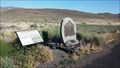
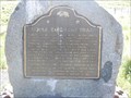
|  Noble Emigrant Trail - Lassen County, CA Noble Emigrant Trail - Lassen County, CA
in Wagon Roads and Trails This official California Historical Marker notes the passage of the Noble Emigrant Trail through this point in 1852. posted by: NW_history_buff location: California date approved: 09/19/2014 last visited: never |
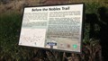 view gallery view gallerySW92.4 km | Before the Nobles Trail - Lassen County, CA in Signs of History This historical placard and official California Historical Marker note the passage of the Noble Emigrant Trail through this point in 1852. posted by: NW_history_buff location: California date approved: 09/19/2014 last visited: never |
 view gallery view gallerySW92.5 km |  Noble Emigrant Trail Noble Emigrant Trail
in California Historical Markers Historic Marker along US395 posted by: CA Boilermaker location: California date approved: 05/27/2008 last visited: 05/26/2014 |
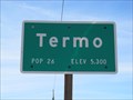 view gallery view galleryW93.2 km | Termo, CA (Southern Approach) - 5300' in Elevation Signs The sign is located at the southern approach to Termo along Highway 395. posted by: WR7X location: California date approved: 03/27/2014 last visited: never |
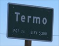 view gallery view galleryW93.3 km | Termo, CA (Northern Approach) - 5300' in Elevation Signs The sign is located at the northern approach to Termo on Highway 395. posted by: WR7X location: California date approved: 03/27/2014 last visited: never |
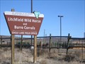 view gallery view gallerySW96.1 km |  Litchfield Wild Horse and Burro Corrals (BLM) - Litchfield, CA Litchfield Wild Horse and Burro Corrals (BLM) - Litchfield, CA
in Humane Societies and Rescues The ultimate rescue operation ... where the wild horses and burros go.... before they are adopted posted by: fishingwishing location: California date approved: 06/12/2008 last visited: 04/27/2012 |
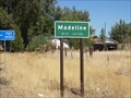 view gallery view galleryW96.9 km |  Madeline, California - Pop. 60 Madeline, California - Pop. 60
in Population Signs Stopped here and sent a postcard to my daughter of the same name (Madeline) posted by: tbarhunt location: California date approved: 11/05/2009 last visited: 03/14/2011 |
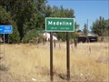 view gallery view galleryW96.9 km | Madeline, California - Elev. 5320' in Elevation Signs City sign with population and elevation information along Highway 395. posted by: Robert04 location: California date approved: 12/22/2011 last visited: 03/20/2014 |
 view gallery view gallery E97.7 km E97.7 km
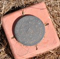
|  NDOT 1074046M ~ Interstate Highway 80 NDOT 1074046M ~ Interstate Highway 80
in U.S. Benchmarks This Nevada Department of Transportation Right-of-Way marker is located on the south side of I-80 at Milepost PE51.04. posted by: brwhiz location: Nevada date approved: 09/13/2012 last visited: never |
|