 view gallery view gallery W6.3 km W6.3 km
|   Hayesville, Ohio- 44838 Hayesville, Ohio- 44838
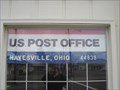
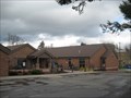
in U.S. Post Offices US Post Office - Hayesville, Ohio 44838 posted by:  Strattonator Strattonator location: Ohio date approved: 04/01/2010 last visited: 03/28/2010 |
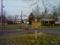
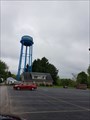 view gallery view galleryW6.4 km |  Hayesville Water Tower - Hayesville, OH Hayesville Water Tower - Hayesville, OH
in Water Towers Hayesville water tower is located in Ashland County. posted by:  LadyKarine LadyKarine location: Ohio date approved: 05/30/2018 last visited: never |
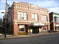
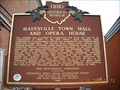 view gallery view galleryW6.6 km |  Hayesville Town Hall and Opera House #1-3 Hayesville Town Hall and Opera House #1-3
in Ohio Historical Markers Located on S Mechanic St Hwy 60 in Hayesville directly behind the post office is the site of this historical marker. posted by: teachingkris location: Ohio date approved: 12/19/2009 last visited: 11/23/2015 |
 view gallery view gallery NW11.7 km NW11.7 km
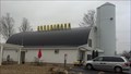
|  Grandpa's Cheese Barn and Village - Ashland, OH Grandpa's Cheese Barn and Village - Ashland, OH
in Official Local Tourism Attractions How can any warm blooded American pass up a joint called Grandpa's Cheese Barn? posted by: DnRseekers location: Ohio date approved: 11/28/2012 last visited: 04/11/2023 |
 view gallery view galleryNW12.4 km |  Wendy's US-250 E - Ashland, Ohio Wendy's US-250 E - Ashland, Ohio
in Wendy's Restaurants Wendy's restaurant in Ashland, OH. posted by: LadyKarine location: Ohio date approved: 06/07/2018 last visited: 09/16/2018 |
 view gallery view galleryNW12.6 km |  ALDI Store - Ashland, OH ALDI Store - Ashland, OH
in ALDI Stores This ALDI Store is located at 1033 Commerce Parkway, Ashland, OH 44805, USA posted by: LadyKarine location: Ohio date approved: 05/29/2018 last visited: never |
 view gallery view galleryNW12.7 km |  Dunkin Donuts - Ashland, Ohio Dunkin Donuts - Ashland, Ohio
in Dunkin Donuts' A Dunkin Donuts Shop located in Ashland, Ohio posted by: machard location: Ohio date approved: 06/04/2018 last visited: never |
 view gallery view gallery N12.9 km N12.9 km
|  Trooper James R. Gross Trooper James R. Gross
in Police Memorials Located along Trooper James R. Gross Memorial Highway at the site of his murder. posted by: Team RAGAR location: Ohio date approved: 07/29/2008 last visited: 05/19/2009 |
 view gallery view gallery SE13.5 km SE13.5 km
|  Brown's Lake Bog Brown's Lake Bog
in U.S. National Natural Landmarks A Kettle Lake, Bogg and Glacier Kame open to the public. posted by: Team RAGAR location: Ohio date approved: 06/11/2012 last visited: 03/23/2019 |
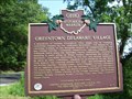 view gallery view gallery SW13.8 km SW13.8 km
| Greentown Delaware Village : #4-3 in Ohio Historical Markers Located next to a barn on State Route 39 near Charles Mill Lake. posted by: Mr. 0 location: Ohio date approved: 07/28/2008 last visited: 04/07/2012 |
 view gallery view gallery S14.8 km S14.8 km
|  Ohio Theater, Loudonville, OH Ohio Theater, Loudonville, OH
in Vintage Movie Theaters An opera house turned theater in Loudonville, OH. posted by: Wallyum location: Ohio date approved: 06/09/2022 last visited: never |
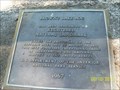
 view gallery view galleryS14.8 km | Charles Franklin Kettering : Marker #3-3 in Ohio Historical Markers Located near the public library in Loudonville, OH. posted by: Mr. 0 location: Ohio date approved: 11/04/2006 last visited: 04/07/2012 |
 view gallery view galleryS14.8 km |  Loudonville Public Library Loudonville Public Library
in Libraries A public library in Loudonville, Ohio. posted by: Strattonator location: Ohio date approved: 04/01/2010 last visited: 04/07/2012 |
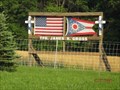
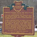 view gallery view galleryW14.8 km | Frontier Violence During the War of 1812 - Marker # 2-3 in Ohio Historical Markers This marker is located at the Charles Mills Lake Damsite parking area. It was erected in 2000 by: The Johnny Appleseed Heritage Center, Inc. and The Ohio Historical Society. posted by: DougandSandra location: Ohio date approved: 03/28/2013 last visited: 07/27/2019 |
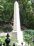 view gallery view galleryW15 km |  Copus Massacre - Ashland County, Ohio Copus Massacre - Ashland County, Ohio
in Wikipedia Entries The site of a battle between Native Americans and early Ohio pioneers during the War of 1812, which came about due to a series of lies and mistakes. posted by: Mr. 0 location: Ohio date approved: 08/05/2008 last visited: 07/27/2019 |
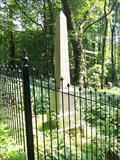 view gallery view galleryW15 km |  Copus Massacre - Ashland County, Ohio Copus Massacre - Ashland County, Ohio
in Battlefields The site of a battle between Native Americans and early Ohio pioneers during the War of 1812, which came about due to a series of lies and mistakes. posted by: Mr. 0 location: Ohio date approved: 08/24/2008 last visited: 07/27/2019 |
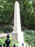 view gallery view galleryW15 km |  Copus Massacre - Ashland County, Ohio Copus Massacre - Ashland County, Ohio
in War of 1812 The site of a battle between Native Americans and early Ohio pioneers during the War of 1812, which came about due to a series of lies and mistakes. posted by: Mr. 0 location: Ohio date approved: 11/22/2008 last visited: 07/27/2019 |
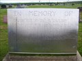
 view gallery view gallerySW15.3 km |  Applegate Family Headstone - Green Lawn Cemetery - Perrysville, Ohio Applegate Family Headstone - Green Lawn Cemetery - Perrysville, Ohio
in Time Capsules The maker of this headstone also built it to house a time capsule as well. posted by: Mr. 0 location: Ohio date approved: 07/31/2008 last visited: never |
 view gallery view gallerySW15.3 km |  Applegate Family - Green Lawn Cemetery - Perrysville, Ohio Applegate Family - Green Lawn Cemetery - Perrysville, Ohio
in Homemade Tombstones A very informational and impressive homemade tombstone in Perrysville, Ohio posted by: Mr. 0 location: Ohio date approved: 07/29/2008 last visited: never |
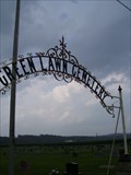 view gallery view gallerySW15.3 km |  Green Lawn Cemetery - Perrysville, Ohio Green Lawn Cemetery - Perrysville, Ohio
in Worldwide Cemeteries A large rural Ohio cemetery. Located just east of Perrysville, in Ashland County, Ohio. posted by: Mr. 0 location: Ohio date approved: 09/03/2008 last visited: 07/25/2024 |
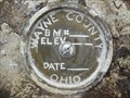 view gallery view gallery NE15.4 km NE15.4 km
|  Wayne County Bench Mark Disk - Chester Twp Wayne County OH Wayne County Bench Mark Disk - Chester Twp Wayne County OH
in U.S. Benchmarks This is a Wayne County bench mark disk set in the southwest wing wall of the Myers Road bridge over Killbuck Creek in Chester Township, Wayne County. posted by: shorbird location: Ohio date approved: 11/24/2014 last visited: never |
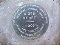 view gallery view galleryNE15.6 km | DH6782(R 238 RESET) - Chester Twp Wayne County OH in U.S. Benchmarks This is a National Geodetic Survey vertical control disk in Chester Township, Wayne County. posted by: shorbird location: Ohio date approved: 11/15/2014 last visited: never |
 view gallery view galleryNW16.6 km |  Applebee's Restaurant - Claremont Ave. - Ashland, OH Applebee's Restaurant - Claremont Ave. - Ashland, OH
in Applebee's Restaurants An Applebee's located at 2250 Claremont Ave, Ashland, OH 44805. posted by: LadyKarine location: Ohio date approved: 06/08/2018 last visited: never |
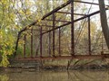 view gallery view galleryW17.4 km |  Crider Rd Pratt through truss - Richland Co, Ohio Crider Rd Pratt through truss - Richland Co, Ohio
in Truss Bridges Abandoned Crider Rd Pratt pinned through truss bridge over Black Fork Mohican River in Richland Co, Ohio. posted by: buffalohiker location: Ohio date approved: 10/25/2012 last visited: 10/13/2012 |
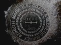 view gallery view gallery E18.5 km E18.5 km
|  CD1994(MYERS AZ MK) - Wooster Twp Wayne County OH CD1994(MYERS AZ MK) - Wooster Twp Wayne County OH
in Azimuth Benchmarks This is the azimuth mark for USC&GS triangulation station MYERS, in Wooster Township, Wayne County. posted by: shorbird location: Ohio date approved: 01/06/2015 last visited: never |
|