 view gallery view gallery S0.3 km S0.3 km
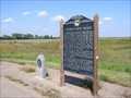
|   Lincoln Highway Marker - Overton, NE Lincoln Highway Marker - Overton, NE
in Lincoln Highway Markers Lincoln Highway marker rescued and on display near the old US Hwy 30 route in Overton, NE. posted by:  plainsdrifter358 plainsdrifter358 location: Nebraska date approved: 11/14/2007 last visited: 11/09/2007 |
 view gallery view gallery E3.1 km E3.1 km
|  THE TOBIN INDIAN RAID THE TOBIN INDIAN RAID
in Nebraska Historical Markers Site of an Indian Raid that resulted in the deaths of railroad employees on April 29, 1868. posted by: plainsdrifter358 location: Nebraska date approved: 11/13/2007 last visited: 11/09/2007 |
 view gallery view gallery W13.5 km W13.5 km
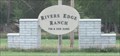
|  River's Edge Llamas -- Lexington NE River's Edge Llamas -- Lexington NE
in Alpaca and Llama Farms A llama ranch along the I-80 at Lexington NE that also offers waterfowl hunting posted by: Benchmark Blasterz location: Nebraska date approved: 02/10/2014 last visited: 05/07/2014 |
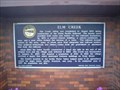 view gallery view galleryE14 km | Elm Creek in Nebraska Historical Markers Elm Creek Historical Marker posted by:  Biker Ozzy Biker Ozzy location: Nebraska date approved: 08/23/2008 last visited: never |
 view gallery view gallery SE16.7 km SE16.7 km
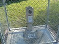
|  Phelps Co., Nebraska marker, Highway 183 Phelps Co., Nebraska marker, Highway 183
in Pony Express Monuments This is an old marker placed by Phelps County, Nebraska. posted by:  NevaP NevaP location: Nebraska date approved: 04/12/2008 last visited: 08/08/2013 |
 view gallery view gallerySE16.7 km | Historic Platte Valley in Nebraska Historical Markers Through this valley passed the Oregon Trail, highway for early explorers, fur traders, California-bound gold seekers, freighters, and brave pioneers seeking new homes in the West. Traffic was especially heavy from 1843 to 1866. At times as many as 800 wagons passed this point daily, heading both directions. posted by: MNSearchers location: Nebraska date approved: 09/19/2006 last visited: 08/08/2013 |
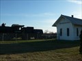 view gallery view galleryW16.9 km |  Union Pacific Steamer No. 485 Union Pacific Steamer No. 485
in Locomotives Static Locomotive Display in Lexington, NE posted by: plainsdrifter358 location: Nebraska date approved: 11/16/2007 last visited: 11/27/2021 |
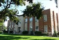
 view gallery view galleryW17.7 km |  Dawson County Courthouse, Lexington, NE Dawson County Courthouse, Lexington, NE
in Courthouses This Beaux Arts style courthouse was built in 1913-1914. posted by: NevaP location: Nebraska date approved: 05/30/2008 last visited: never |
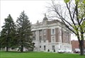 view gallery view galleryW17.7 km |  Dawson County Courthouse, Lexington, NE Dawson County Courthouse, Lexington, NE
in U.S. National Register of Historic Places This 1913 building is Dawson County's second courthouse. posted by: NevaP location: Nebraska date approved: 05/30/2008 last visited: never |
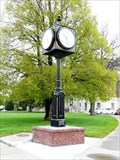 view gallery view galleryW17.7 km |  Lexington 9-11-01 Memorial Clock, Lexington, NE Lexington 9-11-01 Memorial Clock, Lexington, NE
in Town Clocks This four-faced clock is a memorial for the terrorist attacks of September 11, 2001. posted by: NevaP location: Nebraska date approved: 05/31/2008 last visited: never |
 view gallery view galleryW17.7 km |  Memorial Clock, Lexington, Nebraska Memorial Clock, Lexington, Nebraska
in 9/11 Memorial Sites This clock was placed in Lexington, Nebraska as a memorial to the victims of the 9/11 attacks. posted by: NevaP location: Nebraska date approved: 06/02/2008 last visited: never |
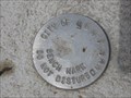 view gallery view galleryS24.8 km |  CITY OF BERTRAND, Nebraska CITY OF BERTRAND, Nebraska
in U.S. Benchmarks CITY OF BERTRAND, NE, is a two-inch aluminum disk set in the top of the concrete footing for the southwest leg of the Bertrand, NE, municipal water tank in Bertrand, Phelps County, NE. posted by: seventhings location: Nebraska date approved: 05/31/2006 last visited: never |
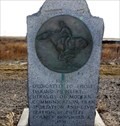
 view gallery view galleryS26.2 km |  Andrew Jackson Widick-Bertrand, NE Andrew Jackson Widick-Bertrand, NE
in Medal Of Honor Resting Places Civil War Medal of Honor Recipient for action at Vicksburg, MS on May 22, 1863. He is buried in Highland Cemetery, Bertrand, NE in Block 4, Lot 32. posted by: Don.Morfe location: Nebraska date approved: 08/19/2019 last visited: 11/10/2021 |
 view gallery view galleryW31.5 km | Central Platte Valley in Nebraska Historical Markers Located in the westbound rest area of I-80 near Cozad. posted by: Markerman62 location: Nebraska date approved: 10/11/2015 last visited: 09/24/2015 |
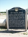 view gallery view galleryE31.9 km |  1733 Ranch - Kearney, NE 1733 Ranch - Kearney, NE
in Geographical Centers The Watson Ranch became known as the 1733 Ranch once it was discovered it was 1,733 miles away from both San Francisco and Boston. posted by: cldisme location: Nebraska date approved: 06/25/2010 last visited: 06/12/2018 |
 view gallery view galleryE31.9 km | The Watson Ranch - Kearney, NE in Nebraska Historical Markers The Watson Ranch became known as the 1733 Ranch once it was discovered it was 1,733 miles away from both San Francisco and Boston. posted by: cldisme location: Nebraska date approved: 06/26/2010 last visited: 05/02/2014 |
 view gallery view galleryE31.9 km |  1733 Ranch House - Kearney, NE 1733 Ranch House - Kearney, NE
in American Guide Series The Watson Ranch became known as the 1733 Ranch once it was discovered it was 1,733 miles away from both San Francisco and Boston. posted by: cldisme location: Nebraska date approved: 06/27/2010 last visited: 05/02/2014 |
 view gallery view gallery SW32.2 km SW32.2 km
| Gosper County Courthouse, Elwood, NE in Courthouses This Art Deco style courthouse was built in 1939. posted by: NevaP location: Nebraska date approved: 09/23/2008 last visited: never |
 view gallery view gallerySW32.2 km | Gosper County Courthouse, Elwood, NE in U.S. National Register of Historic Places This Art Deco style courthouse was built in 1939. posted by: NevaP location: Nebraska date approved: 09/23/2008 last visited: never |
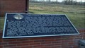
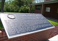 view gallery view galleryW32.8 km | Central Platte Valley in Nebraska Historical Markers This marker presents a summery of the history of Dawson County and the Central Platte Valley. posted by: NevaP location: Nebraska date approved: 06/07/2007 last visited: 09/23/2015 |
 view gallery view galleryE33 km | Kearney - Fort Kearny in Nebraska Historical Markers A marker defining the historical significance of Fort Kearny that was situated near this Interstate rest area. posted by: gatefan location: Nebraska date approved: 03/18/2012 last visited: never |
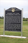 view gallery view gallerySE33.6 km | Holdredge Silt Loam -- US183 nr Holdredge NE in Nebraska Historical Markers Nebraska has an official state dirt. COOL! posted by: Benchmark Blasterz location: Nebraska date approved: 02/11/2014 last visited: 08/08/2013 |
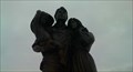 view gallery view gallerySE34.9 km |  Promise of the Prairie - Holdrege, Nebraska Promise of the Prairie - Holdrege, Nebraska
in Figurative Public Sculpture Promise of the Prairie - 100 Years of Family posted by: Eagle1977 location: Nebraska date approved: 01/03/2013 last visited: never |
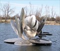 view gallery view galleryE35.7 km |  Nebraska Wind Sculpture Nebraska Wind Sculpture
in Abstract Public Sculptures This in one of eight sculptures placed in I-80 rest areas in 1976.
posted by: NevaP location: Nebraska date approved: 03/28/2007 last visited: 07/12/2017 |
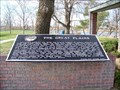 view gallery view galleryE35.9 km | The Great Plains in Nebraska Historical Markers This marker gives a description of the vast geographical area just west of here and a general account of its settlement. posted by: NevaP location: Nebraska date approved: 04/01/2007 last visited: 07/12/2017 |
|