 view gallery view gallery SE6.6 km SE6.6 km
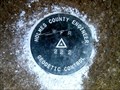
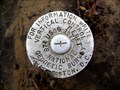
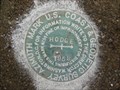
|   222 - Franklin Twp Wayne County OH 222 - Franklin Twp Wayne County OH
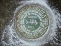
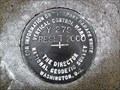
in U.S. Benchmarks This is a Holmes County survey disk in Franklin Township, Wayne County. posted by:  shorbird shorbird location: Ohio date approved: 04/01/2015 last visited: never |
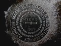 view gallery view gallery N7.1 km N7.1 km
|  CD1994(MYERS AZ MK) - Wooster Twp Wayne County OH CD1994(MYERS AZ MK) - Wooster Twp Wayne County OH
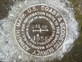
in Azimuth Benchmarks This is the azimuth mark for USC&GS triangulation station MYERS, in Wooster Township, Wayne County. posted by: shorbird location: Ohio date approved: 01/06/2015 last visited: never |
 view gallery view gallery SW7.9 km SW7.9 km
|  Brown's Lake Bog Brown's Lake Bog
in U.S. National Natural Landmarks A Kettle Lake, Bogg and Glacier Kame open to the public. posted by: Team RAGAR location: Ohio date approved: 06/11/2012 last visited: 03/23/2019 |
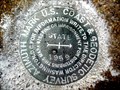 view gallery view gallery NE9 km NE9 km
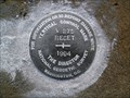
| CD2176(STATE AZ MK) - Wooster Twp Wayne County OH in Azimuth Benchmarks This is the azimuth mark for USC&GS triangulation station STATE 2, in Wooster Township, Wayne County. posted by: shorbird location: Ohio date approved: 01/06/2015 last visited: never |
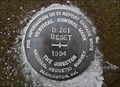
 view gallery view gallery E10.1 km E10.1 km
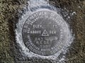
| 974 RESET - Fredericksburg OH in U.S. Benchmarks This is National Geodetic Survey vertical control mark in Fredericksburg, Wayne County. posted by: shorbird location: Ohio date approved: 04/04/2015 last visited: never |
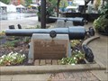 view gallery view galleryN10.3 km |  Pensacola Parrott Guns Pensacola Parrott Guns
in U.S. Civil War Sites The site consists of two Parrott Guns from the Civil War Battleship the Pensacola. posted by:  redwolf5 redwolf5 location: Ohio date approved: 12/04/2016 last visited: never |
 view gallery view gallerySE10.3 km | D 261 RESET 1994 - Prairie Twp Holmes County OH in U.S. Benchmarks This is an NGS Vertical Control Mark disk set in the southwest wing wall of a bridge in Prairie Township, Holmes County. posted by: shorbird location: Ohio date approved: 12/23/2011 last visited: never |
 view gallery view galleryN10.3 km |  Wayne County Courthouse - Wooster Ohio Wayne County Courthouse - Wooster Ohio
in Courthouses Wayne County Courthouse - 107 W Liberty St, Wooster Ohio posted by: buffalohiker location: Ohio date approved: 02/08/2016 last visited: 09/17/2016 |
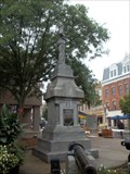 view gallery view galleryN10.5 km | Wayne County Civil War Memorial in U.S. Civil War Sites This monument depicts a Union soldier with pack and gun at parade rest. The monument faces the courthouse in downtown Wooster, Ohio. posted by: redwolf5 location: Ohio date approved: 09/18/2016 last visited: never |
 view gallery view galleryNE11.4 km | CREST AZ MK - Ohio in Azimuth Benchmarks This is the azimuth mark for triangulation station CREST, in Wooster Township, Wayne County. posted by: shorbird location: Ohio date approved: 07/03/2010 last visited: never |
 view gallery view gallerySE11.9 km | 843 RESET 1982 in U.S. Benchmarks This is a USGS survey disk set in a bridge abutment in Prairie Township, Holmes County. posted by: shorbird location: Ohio date approved: 12/23/2011 last visited: never |
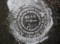 view gallery view gallerySE13.5 km | KERR AZ MK - Ohio in Azimuth Benchmarks This is the azimuth mark for triangulation station KERR, in Salt Creek Township, Holmes County. posted by: shorbird location: Ohio date approved: 12/05/2011 last visited: never |
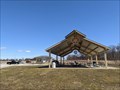 view gallery view galleryN14 km |  Oak Hill Park Pavilion - Wooster, OH Oak Hill Park Pavilion - Wooster, OH
in Rotary International Markers A large Rotary Club gear wheel on a pavilion in Wooster, OH. posted by: TyroneShoelaces location: Ohio date approved: 10/07/2021 last visited: 10/09/2021 |
 view gallery view galleryNE14.5 km | CD1867(HODGE AZ MK) - East Union Twp Wayne County OH in Azimuth Benchmarks This is the azimuth mark for USC&GS triangulation station HODGE. It is in East Union Township, Wayne County. posted by: shorbird location: Ohio date approved: 12/08/2014 last visited: never |
 view gallery view gallery S15.4 km S15.4 km
| V 275 RESET 1994 - Hardy Twp Holmes County OH in U.S. Benchmarks This is vertical control mark V 275 RESET 1994, set in a bridge in Hardy Township, Holmes County. posted by: shorbird location: Ohio date approved: 12/23/2011 last visited: never |
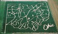 view gallery view galleryNE16.6 km |  Ohio Corn Maze - Ramseyer Farm Ohio Corn Maze - Ramseyer Farm
in Outdoor Mazes Located in Wayne County Ohio each year Ramseyer Farm offers two Corm Mazes, one in the shape of the State of Ohio and a mystery maze posted by: 5hills location: Ohio date approved: 11/18/2009 last visited: never |
 view gallery view gallerySW16.6 km |  Nashville, OH Nashville, OH
in Small Town, Big Name Nashville, Ohio, is a small community of less than 200 in the heart of Ohio's Amish country, in contrast to America's music capital of Nashville, Tennessee, with more than a half million residents. posted by: silverquill location: Ohio date approved: 02/09/2009 last visited: 03/23/2019 |
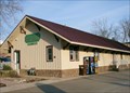
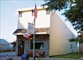 view gallery view gallerySW16.9 km |  Nashville, OH 44661 Nashville, OH 44661
in U.S. Post Offices This is the post office for the small town of Nashville, Ohio. posted by: silverquill location: Ohio date approved: 02/07/2009 last visited: 03/23/2019 |
 view gallery view gallerySE17.1 km | Y 279 RESET 2000 - Salt Creek Twp Holmes County OH in U.S. Benchmarks This is a National Geodetic Survey vertical control mark, set in 2000 to replace the mark reset in 1975(KY2891), in Salt Creek Township, Holmes County Ohio. This mark has no PID. posted by: shorbird location: Ohio date approved: 12/01/2011 last visited: never |
 view gallery view galleryNE17.5 km | CD2186(SUGAR AZ MK) - East Union Twp Wayne County OH in Azimuth Benchmarks This is the azimuth mark for USC&GS triangulation station SUGAR, in East Union Township, Wayne County. posted by: shorbird location: Ohio date approved: 12/09/2014 last visited: never |
 view gallery view galleryS17.7 km |  Brightman House - Millersburg, Ohio Brightman House - Millersburg, Ohio
in U.S. National Register of Historic Places L.H. Brightman House, 484 Wooster Rd, Millersburg was built in 1902. posted by: buffalohiker location: Ohio date approved: 04/27/2011 last visited: 04/26/2011 |
 view gallery view galleryS18 km |  Holmes County Rail to Trail - Millersburg, OH Holmes County Rail to Trail - Millersburg, OH
in Rails to Trails There are 15 miles of Rail to Trails in the stretch in Holmes County, Ohio, stretching from Fredericksburg through Millersburg. This is an access point at Hipp Station in Millersburg. posted by: silverquill location: Ohio date approved: 04/07/2008 last visited: 11/09/2018 |
 view gallery view galleryS18 km |  Hipp Station - Millersburg, OH Hipp Station - Millersburg, OH
in Train Stations/Depots The Hipp Station in Millersburg, Ohio, is now offices for the park department and entrance point for the Rail Trail system. posted by: silverquill location: Ohio date approved: 04/08/2008 last visited: 11/09/2018 |
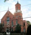 view gallery view galleryS18 km |  Grace Pointe Community Church (United Methodist Church) - Millersburg, OH Grace Pointe Community Church (United Methodist Church) - Millersburg, OH
in This Old Church The old United Methodist Church building in Millersburg, Ohio, is a fine example of the Romanesque architecture in the area. It was built in 1871. posted by: silverquill location: Ohio date approved: 04/17/2012 last visited: 11/10/2021 |
 view gallery view galleryS18 km | United Methodist Church - Millersburg, OH in U.S. National Register of Historic Places The old United Methodist Church building in Millersburg, Ohio, is a fine example of the Romanesque architecture in the area. It was built in 1871. posted by: silverquill location: Ohio date approved: 04/18/2012 last visited: 11/10/2021 |
|