 view gallery view gallery S0.5 km S0.5 km
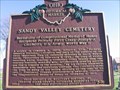
|   Sandy Valley Cemetery #5-76 Sandy Valley Cemetery #5-76
in Ohio Historical Markers Located on Ohio State Rt. 183, Stark Co., Waynesburg, Ohio posted by:  buckeyealum buckeyealum location: Ohio date approved: 11/23/2006 last visited: 02/23/2011 |
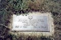 view gallery view galleryS0.6 km |  Joseph J Cicchetti-Waynesburg, OH Joseph J Cicchetti-Waynesburg, OH
in Medal Of Honor Resting Places World War II Medal of Honor Recipient for action in South Manila, Luzon, Philippine Islands on February 9, 1945. He was killed in action. He is buried in Sandy Valley Cemetery, Waynesburg, OH in Section D, Lot 615. posted by: Don.Morfe location: Ohio date approved: 10/25/2017 last visited: 12/19/2021 |
 view gallery view gallery SW2.7 km SW2.7 km
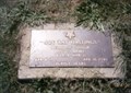
| Joe R. Hastings-Magnolia, OH in Medal Of Honor Resting Places World War II Medal of Honor Recipient for action at Drabenderhohe, Germany on April 12, 1945. He was killed in action. He is buried in Magnolia Cemetery, Magnolia, OH. posted by: Don.Morfe location: Ohio date approved: 11/08/2017 last visited: 12/19/2021 |
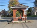
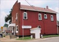
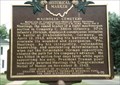 view gallery view gallerySW2.9 km | Magnolia Cemetery-Magnolia, OH in Ohio Historical Markers This marker is about World War II Medal of Honor Recipient Joe R. Hastings who is buried in Magnolia Cemetery. It is located at the intersection of North Brady Street and Harrison Street in Magnolia OH 44643. posted by: Don.Morfe location: Ohio date approved: 11/15/2017 last visited: 10/19/2021 |
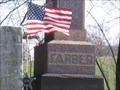 view gallery view gallerySW4.3 km | Phillip Farber in American Revolutionary War Veteran Graves The Patriot geocache is also located nearby. posted by: buckeyealum location: Ohio date approved: 10/30/2008 last visited: never |
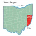 view gallery view gallerySW4.7 km |  Seven Ranges Boundary Marker Seven Ranges Boundary Marker
in U.S. Historic Survey Stones and Monuments The north west corner of the Seven Ranges Boundary in Ohio. posted by: Team RAGAR location: Ohio date approved: 10/19/2008 last visited: 08/27/2017 |
 view gallery view gallery W6.3 km W6.3 km
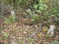
|  Eakin Burial Plot Eakin Burial Plot
in Abandoned Cemeteries The forgotten graves of four children. posted by: Team RAGAR location: Ohio date approved: 01/29/2008 last visited: 08/27/2017 |
 view gallery view gallerySW6.6 km |  Eight Corner School House Eight Corner School House
in Octagon Buildings Magnolia, Ohio posted by: Team RAGAR location: Ohio date approved: 09/08/2008 last visited: 10/18/2014 |
 view gallery view galleryW7.2 km |  The Town Pump of East Sparta - East Sparta, OH The Town Pump of East Sparta - East Sparta, OH
in Hand Operated Water Pumps The East Sparta town pump has been located in the middle on the main intersection of this small town for over 150 years. posted by: linkys location: Ohio date approved: 11/25/2011 last visited: never |
 view gallery view galleryW7.2 km |  Town Pump of East Sparta , The - East Sparta, OH Town Pump of East Sparta , The - East Sparta, OH
in U.S. National Register of Historic Places The East Sparta town pump has been located in the middle on the main intersection of this small town for over 150 years. posted by: linkys location: Ohio date approved: 11/24/2011 last visited: never |
 view gallery view gallery E8.7 km E8.7 km
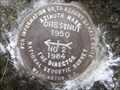
|  CHESTNUT AZ MK 2 - Ohio CHESTNUT AZ MK 2 - Ohio
in Azimuth Benchmarks This is the azimuth mark for station CHESTNUT, in Brown Township, Carroll County. posted by: shorbird location: Ohio date approved: 07/20/2008 last visited: 10/26/2008 |
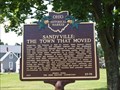 view gallery view galleryW9.2 km | Sandyville: The Town that Moved in Ohio Historical Markers This sign is located at the intersection of Cross Roads Rd NE, Sandyville Rd and Beckel Ave. It was dedicated July 25, 2015. Interestingly, the remarkableohio web site does not include this marker - it jumps from #24-79 to #26-79. posted by:  buffalohiker buffalohiker location: Ohio date approved: 09/06/2017 last visited: 08/26/2017 |
 view gallery view gallery N10.1 km N10.1 km
| WACO AZ MK - Ohio in Azimuth Benchmarks This is the azimuth mark for station WACO. The azimuth is in Osnaburg Township, Stark County. posted by: shorbird location: Ohio date approved: 03/21/2010 last visited: never |
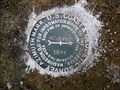 view gallery view gallerySW10.6 km | SCHAFER AZ MK - Ohio in Azimuth Benchmarks This is the azimuth mark for triangulation station SCHAFER, in Sandy Township, Tuscarawas County. posted by: shorbird location: Ohio date approved: 03/07/2012 last visited: never |
 view gallery view galleryN11.4 km | CD2142(SHUPE AZ MK) - Osnaburg Twp Stark County OH in Azimuth Benchmarks This is the azimuth mark for USC&GS triangulation station SHUPE, in Osnaburg Township, Stark County. posted by: shorbird location: Ohio date approved: 05/07/2017 last visited: never |
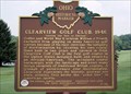
 view gallery view galleryN11.7 km |  Clearview Golf Club - East Canton, OH Clearview Golf Club - East Canton, OH
in Lincoln Highway This historic course was opened in 1948 by Bill Powell who was barred from other country clubs, and is the only course designed, built, owned, and operated by an African American. It is located on the historic Lincoln Highway near East Canton, Ohio. posted by: silverquill location: Ohio date approved: 01/02/2009 last visited: never |
 view gallery view galleryN11.7 km | Clearview Golf Club, 1946 (#7-76) - East Canton, OH in Ohio Historical Markers his historic course was opened in 1948 by Bill Powell who was barred from other country clubs, and is the only course designed, built, owned, and operated by an African American. It is located on the historic Lincoln Highway near East Canton, Ohio. posted by: silverquill location: Ohio date approved: 01/02/2009 last visited: 08/12/2018 |
 view gallery view galleryN11.7 km |  Clearview Golf Club - East Canton, OH Clearview Golf Club - East Canton, OH
in Civil Rights Memorials This historic course was opened in 1948 by Bill Powell who was barred from other country clubs, and is the only course designed, built, owned, and operated by an African American. It is located on the historic Lincoln Highway near East Canton, Ohio. posted by: silverquill location: Ohio date approved: 01/04/2009 last visited: never |
 view gallery view galleryN11.7 km |  Clearview Golf Club - East Canton, OH Clearview Golf Club - East Canton, OH
in Public and Private Golf Courses This historic course was opened in 1948 by Bill Powell who was barred from other country clubs, and is the only course designed, built, owned, and operated by an African American. It is located on the historic Lincoln Highway near East Canton, Ohio. posted by: silverquill location: Ohio date approved: 01/05/2009 last visited: never |
 view gallery view galleryN11.7 km | Clearview Golf Club - East Canton, OH in U.S. National Register of Historic Places This historic course was opened in 1948 by Bill Powell who was barred from other country clubs, and is the only course designed, built, owned, and operated by an African American. It is located on the historic Lincoln Highway near East Canton, Ohio. posted by: silverquill location: Ohio date approved: 01/02/2009 last visited: never |
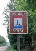 view gallery view galleryN12.1 km | Lincoln Highway Marker - Stark County, OH in Lincoln Highway Markers This Lincoln Highway Marker is located on a straight stretch just east of the historic Clearview Golf Club, between the towns of East Canton and Robersville in rural Stark County, Ohio. posted by: silverquill location: Ohio date approved: 01/02/2009 last visited: never |
 view gallery view gallery NE12.1 km NE12.1 km
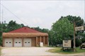
|  Robertsville Vol. Fire Dept. Robertsville Vol. Fire Dept.
in Firehouses This is a rural volunteer fire department in Stark County, serving the area around Robertsville, Ohio. posted by: silverquill location: Ohio date approved: 01/02/2009 last visited: 05/10/2009 |
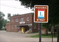 view gallery view galleryNE12.2 km | Lincoln Highway Marker - Robertsville, OH in Lincoln Highway Markers This Lincoln Highway marker is located near the Hitchin Post in Robertsville, Ohio. posted by: silverquill location: Ohio date approved: 01/02/2009 last visited: 05/10/2009 |
 view gallery view galleryNE12.2 km |  Robertsville, OH 44670 Robertsville, OH 44670
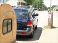
in U.S. Post Offices This is the post office in an older building for the town of Robertsville, Ohio, on the historic Lincoln Highway. posted by: silverquill location: Ohio date approved: 08/18/2008 last visited: 07/20/2009 |
 view gallery view galleryNE12.2 km | Lincoln Highway Marker - Robertsville PO, OH in Lincoln Highway Markers This Lincoln Highway marker is located right in front of the Robertsville, Ohio, post office. The post office is located at 11315 Lincoln Street, SE. posted by: HaricotVert_52 location: Ohio date approved: 07/31/2009 last visited: 07/20/2009 |
|