 view gallery view gallery NE3.9 km NE3.9 km
|   Brown's Lake Bog Brown's Lake Bog
in U.S. National Natural Landmarks A Kettle Lake, Bogg and Glacier Kame open to the public. posted by:  Team RAGAR Team RAGAR location: Ohio date approved: 06/11/2012 last visited: 03/23/2019 |
 view gallery view gallery S7.6 km S7.6 km
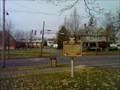
|  Nashville, OH 44661 Nashville, OH 44661
in U.S. Post Offices This is the post office for the small town of Nashville, Ohio. posted by:  silverquill silverquill location: Ohio date approved: 02/07/2009 last visited: 03/23/2019 |
 view gallery view galleryS7.7 km |  Nashville, OH Nashville, OH
in Small Town, Big Name Nashville, Ohio, is a small community of less than 200 in the heart of Ohio's Amish country, in contrast to America's music capital of Nashville, Tennessee, with more than a half million residents. posted by: silverquill location: Ohio date approved: 02/09/2009 last visited: 03/23/2019 |
 view gallery view gallery W11.1 km W11.1 km
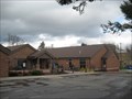
|  Loudonville Public Library Loudonville Public Library
in Libraries A public library in Loudonville, Ohio. posted by: Strattonator location: Ohio date approved: 04/01/2010 last visited: 04/07/2012 |
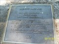
 view gallery view galleryW11.3 km |  Charles Franklin Kettering : Marker #3-3 Charles Franklin Kettering : Marker #3-3
in Ohio Historical Markers Located near the public library in Loudonville, OH. posted by: Mr. 0 location: Ohio date approved: 11/04/2006 last visited: 04/07/2012 |
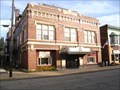 view gallery view galleryW11.4 km |  Ohio Theater, Loudonville, OH Ohio Theater, Loudonville, OH
in Vintage Movie Theaters An opera house turned theater in Loudonville, OH. posted by: Wallyum location: Ohio date approved: 06/09/2022 last visited: never |
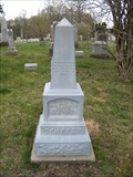 view gallery view gallery SW13.7 km SW13.7 km
|  George Schafer - Holmes County, Ohio George Schafer - Holmes County, Ohio
in Zinc Headstones A smaller Zinc headstone in Kaylor Ridge Cemetery. posted by: Mr. 0 location: Ohio date approved: 04/20/2010 last visited: never |
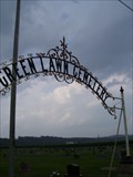
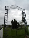 view gallery view gallerySW13.7 km |  Kaylor Ridge Cemetery - Greer, Ohio Kaylor Ridge Cemetery - Greer, Ohio
in Worldwide Cemeteries A older rural cemetery just north of Greer, Ohio posted by: Mr. 0 location: Ohio date approved: 04/19/2010 last visited: never |
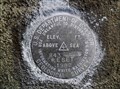
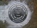
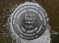 view gallery view gallery E15 km E15 km
|  D 261 RESET 1994 - Prairie Twp Holmes County OH D 261 RESET 1994 - Prairie Twp Holmes County OH
in U.S. Benchmarks This is an NGS Vertical Control Mark disk set in the southwest wing wall of a bridge in Prairie Township, Holmes County. posted by: shorbird location: Ohio date approved: 12/23/2011 last visited: never |
 view gallery view galleryE15.3 km | 222 - Franklin Twp Wayne County OH in U.S. Benchmarks This is a Holmes County survey disk in Franklin Township, Wayne County. posted by: shorbird location: Ohio date approved: 04/01/2015 last visited: never |
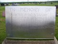
 view gallery view galleryW16.1 km |  Applegate Family Headstone - Green Lawn Cemetery - Perrysville, Ohio Applegate Family Headstone - Green Lawn Cemetery - Perrysville, Ohio
in Time Capsules The maker of this headstone also built it to house a time capsule as well. posted by: Mr. 0 location: Ohio date approved: 07/31/2008 last visited: never |
 view gallery view galleryW16.1 km |  Applegate Family - Green Lawn Cemetery - Perrysville, Ohio Applegate Family - Green Lawn Cemetery - Perrysville, Ohio
in Homemade Tombstones A very informational and impressive homemade tombstone in Perrysville, Ohio posted by: Mr. 0 location: Ohio date approved: 07/29/2008 last visited: never |
 view gallery view galleryW16.3 km | Green Lawn Cemetery - Perrysville, Ohio in Worldwide Cemeteries A large rural Ohio cemetery. Located just east of Perrysville, in Ashland County, Ohio. posted by: Mr. 0 location: Ohio date approved: 09/03/2008 last visited: 07/25/2024 |
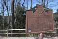 view gallery view galleryW16.4 km | Clear Fork Gorge: A Feature of Ohio's Forests in Ohio Historical Markers Marker is adjacent to the gorge overlook parking lot, about one mile NW of Ohio Route 97, in Mohican State Park. Erected in 2003 by Ohio Bicentennial Commission, The International Paper Company Foundation, and The Ohio Historical Society. posted by: buffalohiker location: Ohio date approved: 04/07/2019 last visited: 03/23/2019 |
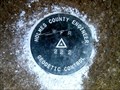
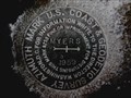 view gallery view galleryNE16.7 km |  CD1994(MYERS AZ MK) - Wooster Twp Wayne County OH CD1994(MYERS AZ MK) - Wooster Twp Wayne County OH
in Azimuth Benchmarks This is the azimuth mark for USC&GS triangulation station MYERS, in Wooster Township, Wayne County. posted by: shorbird location: Ohio date approved: 01/06/2015 last visited: never |
 view gallery view galleryE16.7 km | 843 RESET 1982 in U.S. Benchmarks This is a USGS survey disk set in a bridge abutment in Prairie Township, Holmes County. posted by: shorbird location: Ohio date approved: 12/23/2011 last visited: never |
 view gallery view gallerySW17.9 km |  Greer Wesleyan Church - Greer, OH Greer Wesleyan Church - Greer, OH
in Wesleyan Churches This is the Wesleyan Church for the rural, unincorporated town of Greer, Ohio. posted by: silverquill location: Ohio date approved: 11/19/2007 last visited: never |
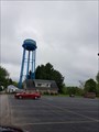 view gallery view gallery NW17.9 km NW17.9 km
|  Hayesville Water Tower - Hayesville, OH Hayesville Water Tower - Hayesville, OH
in Water Towers Hayesville water tower is located in Ashland County. posted by: LadyKarine location: Ohio date approved: 05/30/2018 last visited: never |
 view gallery view galleryNW17.9 km | Hayesville, Ohio- 44838 in U.S. Post Offices US Post Office - Hayesville, Ohio 44838 posted by: Strattonator location: Ohio date approved: 04/01/2010 last visited: 03/28/2010 |
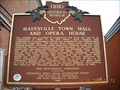 view gallery view galleryNW18 km | Hayesville Town Hall and Opera House #1-3 in Ohio Historical Markers Located on S Mechanic St Hwy 60 in Hayesville directly behind the post office is the site of this historical marker. posted by: teachingkris location: Ohio date approved: 12/19/2009 last visited: 11/23/2015 |
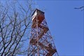 view gallery view galleryW18 km |  Mohican Fire Tower - Ohio Mohican Fire Tower - Ohio
in Look-Out Towers The fire tower at Mohican was built by young men (and engineers) of the Civilian Conservation Corps in 1934 to overlook their massive planting project. At that time it stood on top of a nearly barren hilltop and gave a view of orderly rows of small seedlings. posted by: buffalohiker location: Ohio date approved: 03/30/2019 last visited: 03/23/2019 |
 view gallery view gallery SE18.3 km SE18.3 km
| V 275 RESET 1994 - Hardy Twp Holmes County OH in U.S. Benchmarks This is vertical control mark V 275 RESET 1994, set in a bridge in Hardy Township, Holmes County. posted by: shorbird location: Ohio date approved: 12/23/2011 last visited: never |
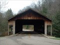 view gallery view galleryW18.7 km |  Mohican State Park Mohican State Park
in Covered Bridges Water: Clear Fork Mohican River, 150', 1969 Cement deck.
posted by: Earthcat location: Ohio date approved: 06/19/2006 last visited: 03/23/2019 |
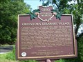 view gallery view galleryW19 km | Greentown Delaware Village : #4-3 in Ohio Historical Markers Located next to a barn on State Route 39 near Charles Mill Lake. posted by: Mr. 0 location: Ohio date approved: 07/28/2008 last visited: 04/07/2012 |
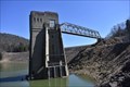 view gallery view galleryW19.2 km |  Pleasant Hill Dam - Perrysville, Ohio Pleasant Hill Dam - Perrysville, Ohio
in Water Dams Pleasant Hill Lake is an 783-acre man made lake located near Perrysville and between Ashland and Richland counties in Ohio. Completed in 1936, Pleasant Hill Dam was built on the Clear Fork of the Mohican River. The dam which forms the lake is a 113 ft (34 m) tall earth-fill dam. It is located in Ashland but the lake extends into Richland. The lake, constructed by the United States Army Corps of Engineers, was built for the purpose of flood control. posted by: buffalohiker location: Ohio date approved: 04/16/2019 last visited: 03/23/2019 |
|