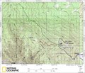
 view gallery view gallery NW0 km NW0 km
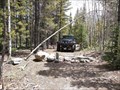
|   Crystal Mountain 4x4 area Crystal Mountain 4x4 area
in Offroad Trails This is the crystal mountain 4x4 area. posted by:  KingJR KingJR location: Colorado date approved: 01/17/2006 last visited: never |
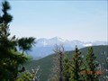
 view gallery view gallery W1.8 km W1.8 km
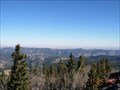
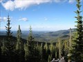
|  Crystal Mountain Crystal Mountain
in Mountain Summits Summit of Crystal Mountain, in Buckhorn Canyon - Larimer County, CO. posted by: KingJR location: Colorado date approved: 11/24/2005 last visited: never |
  S2.6 km S2.6 km
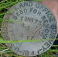
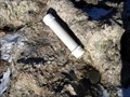
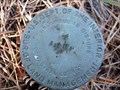
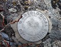
|  Crystal Mountain unknown U.S.G.S. Benchmark Crystal Mountain unknown U.S.G.S. Benchmark
in U.S. Benchmarks Stumbled upon this benchmark while ATVing Crystal Mountain back in August. posted by: KingJR location: Colorado date approved: 11/25/2005 last visited: never |
 view gallery view gallery NE6.1 km NE6.1 km
| Moody Hill 4x4 area in Offroad Trails Moody hill 4x4 area posted by: KingJR location: Colorado date approved: 01/17/2006 last visited: 06/28/2012 |
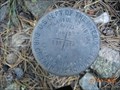
 view gallery view galleryNW7.1 km | Greer Land Office Survey Disk in U.S. Benchmarks US General Land Office Survey Disk, stamped 1961 posted by: KingJR location: Colorado date approved: 08/06/2006 last visited: never |
 view gallery view galleryS7.9 km | Storm Mountain Cadastral Survery disk in U.S. Benchmarks Cadastral Survey Disk near Storm Mountain Summit posted by: KingJR location: Colorado date approved: 11/26/2005 last visited: never |
 view gallery view gallery SE8 km SE8 km
| Storm Mountain Trail in Offroad Trails Storm Mountain trail area posted by: KingJR location: Colorado date approved: 01/17/2006 last visited: never |
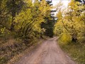
 view gallery view gallery SW8.7 km SW8.7 km
|  Bulwark Ridge Trail Bulwark Ridge Trail
in Scenic Hikes A wonderful hike on top of Bulwark Ridge that takes you to the summit of South Signal Mountain. posted by: KingJR location: Colorado date approved: 07/03/2007 last visited: 05/11/2010 |
 view gallery view galleryNE9.3 km | Old Flowers Road in Offroad Trails Old Flowers Road - Scenic area posted by: KingJR location: Colorado date approved: 01/17/2006 last visited: 08/24/2009 |
 view gallery view galleryNW12.2 km | Monument Gulch Trail in Offroad Trails Monument Gulch Trailhead posted by: KingJR location: Colorado date approved: 01/17/2006 last visited: never |
 view gallery view galleryS12.6 km |  Crosier Mountain Summit Register Crosier Mountain Summit Register
in Summit Registers The Croiser Mountain Summit Register can be found at 9,250ft above sea level, after a 4 mile hike in. posted by:  Team Laxson Team Laxson location: Colorado date approved: 11/16/2008 last visited: 05/11/2010 |
S12.6 km | Crosier Mountain in Mountain Summits One of the small summits in this part of CO, but the views to the East and West are awesome. posted by: Tahosa and Sons location: Colorado date approved: 11/07/2005 last visited: 06/08/2008 |
 view gallery view galleryS12.9 km |  Tahosa - Trekker of Crosier Mountain Tahosa - Trekker of Crosier Mountain
in Geocaching Tour Guides Waymark was moved to AZ in 2009, a year after I left CO. But we have returned to the Mountains of CO in 2015. I can still hike but a wee bit slower due to some physical changes. posted by: Tahosa and Sons location: Arizona date approved: 11/04/2005 last visited: 12/26/2005 |
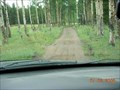
 view gallery view galleryW13.4 km | Trail 234 - Pingree Park Area in Offroad Trails Un-named trail #234 near Pingree Park Colorado posted by: KingJR location: Colorado date approved: 01/01/2016 last visited: never |
 view gallery view gallerySE13.8 km | Palasade Mtn Trailhead Survey Disk in U.S. Benchmarks Cadastral Survey disk near the Trailhead to Palasade Mountain. posted by: KingJR location: Colorado date approved: 11/26/2005 last visited: never |
 view gallery view galleryW13.8 km |  B17 near Pingree Park, CO B17 near Pingree Park, CO
in Plane Crash Sites Boeing B17 Flying Fortress that crashed October 19, 1943. posted by: supradave location: Colorado date approved: 10/24/2005 last visited: 07/13/2006 |
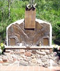 view gallery view gallerySE15.1 km |  Big Thompson Flash Flood - Drake, CO Big Thompson Flash Flood - Drake, CO
in Disaster Memorials 144 people, mostly camping alongside the river, were swept away in a 1976 flash flood posted by: ronjean location: Colorado date approved: 06/20/2010 last visited: 05/04/2019 |
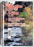 view gallery view gallerySE15.1 km |  The Big Thompson Flood - Drake, CO The Big Thompson Flood - Drake, CO
in There's a Book About It The flash flood took the lives of 144 people in 1976. "Reflection on the River" contains memories by the survivors. posted by: ronjean location: Colorado date approved: 07/19/2010 last visited: 05/04/2019 |
 view gallery view gallerySE15.4 km |  Highway 34 Reopens in Big Thompson Canyon Highway 34 Reopens in Big Thompson Canyon
in News Article Locations After massive flooding closed Highway 34 between Estes Park and Loveland in September 2013, the road was reopened November 21, 2013. posted by: DnRseekers location: Colorado date approved: 03/10/2014 last visited: 05/04/2019 |
 view gallery view gallerySW15.6 km | Rocky Mountain National Park Sheep Mountain 9796 in U.S. Benchmarks At the top of Sheep Mountain Peak 9796 in Rocky Mountain National Park posted by: AlanC location: Colorado date approved: 10/24/2010 last visited: never |
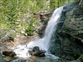 view gallery view gallerySW16.7 km | Bridal Veil Falls in Scenic Hikes A beautiful walk through Colorado's colorful Rocky Mountain National Park. This 3 mile hike will take you through Aspen, Ponderosa Pine, and ending with a 20 foot waterfall of crystal clear mountain water. posted by: Team Laxson location: Colorado date approved: 05/28/2010 last visited: 05/31/2010 |
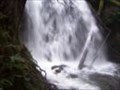 view gallery view gallerySW16.9 km |  Bridal Veil Falls Bridal Veil Falls
in Waterfalls This is a nice hike, seeing several smaller step type falls, ends at a nice curtain cascade, hence, veil. posted by: sewnsew location: Colorado date approved: 06/19/2006 last visited: 05/31/2010 |
 view gallery view gallery N16.9 km N16.9 km
| Youngs Gulch in Scenic Hikes A nice hike that overlooks the stove prarie road when you reach the summit. posted by: KingJR location: Colorado date approved: 07/03/2007 last visited: 09/30/2011 |
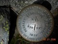 view gallery view galleryW17.2 km | Beaver Creak BLM Cadastral Survey Disk in U.S. Benchmarks BLM Cadastral Survey Disk. posted by: KingJR location: Colorado date approved: 05/21/2006 last visited: never |
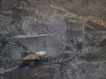
 view gallery view gallerySE17.7 km |  Loveland Mountain Power Station, Larimer County, Colorado, USA Loveland Mountain Power Station, Larimer County, Colorado, USA
in Hydroelectric Power Stations The generators are all that was left of the power plant after the Big Thompson River flash flood of 1976. posted by: ronjean location: Colorado date approved: 12/05/2012 last visited: 10/06/2021 |
|