 view gallery view gallery SW0 km SW0 km
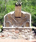
|   Big Thompson Flash Flood - Drake, CO Big Thompson Flash Flood - Drake, CO
in Disaster Memorials 144 people, mostly camping alongside the river, were swept away in a 1976 flash flood posted by:  ronjean ronjean location: Colorado date approved: 06/20/2010 last visited: 05/04/2019 |
 view gallery view gallerySW0 km |  The Big Thompson Flood - Drake, CO The Big Thompson Flood - Drake, CO
in There's a Book About It The flash flood took the lives of 144 people in 1976. "Reflection on the River" contains memories by the survivors. posted by: ronjean location: Colorado date approved: 07/19/2010 last visited: 05/04/2019 |
 view gallery view gallery E0.5 km E0.5 km
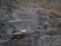
|  Highway 34 Reopens in Big Thompson Canyon Highway 34 Reopens in Big Thompson Canyon
in News Article Locations After massive flooding closed Highway 34 between Estes Park and Loveland in September 2013, the road was reopened November 21, 2013. posted by:  DnRseekers DnRseekers location: Colorado date approved: 03/10/2014 last visited: 05/04/2019 |
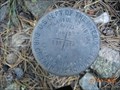
 view gallery view gallery NW1.3 km NW1.3 km
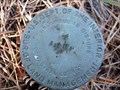
|  Palasade Mtn Trailhead Survey Disk Palasade Mtn Trailhead Survey Disk
in U.S. Benchmarks Cadastral Survey disk near the Trailhead to Palasade Mountain. posted by: KingJR location: Colorado date approved: 11/26/2005 last visited: never |
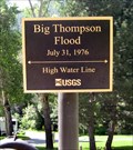 view gallery view galleryE3.1 km |  Big Thompson Flash Flood, 1976, Drake, CO Big Thompson Flash Flood, 1976, Drake, CO
in High Level Marks The flash flood took the lives of 144 people as it swept down the canyon posted by: ronjean location: Colorado date approved: 06/20/2010 last visited: 06/28/2012 |
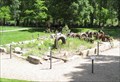 view gallery view galleryE3.1 km |  Loveland Mountain Power Station, Larimer County, Colorado, USA Loveland Mountain Power Station, Larimer County, Colorado, USA
in Hydroelectric Power Stations The generators are all that was left of the power plant after the Big Thompson River flash flood of 1976. posted by: ronjean location: Colorado date approved: 12/05/2012 last visited: 10/06/2021 |
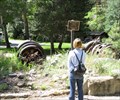 view gallery view galleryE3.1 km |  Loveland Mountain Power Generator, Larimer County, Colorado Loveland Mountain Power Generator, Larimer County, Colorado
in Preserved Machines on Public Display The generators are all that was left of the power plant after the Big Thompson River flash flood of 1976. posted by: ronjean location: Colorado date approved: 04/14/2013 last visited: 05/04/2019 |
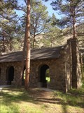 view gallery view galleryE3.1 km |  Viestenz-Smith Mountain Park - Loveland, CO Viestenz-Smith Mountain Park - Loveland, CO
in Civilian Conservation Corps Civilian Conservation Corps (CCC)crews construct four buildings for the Viestenz-Smith Mountain Park in 1934 posted by: Walking Boots location: Colorado date approved: 12/27/2020 last visited: never |
 view gallery view gallery W5.3 km W5.3 km
|  Tahosa - Trekker of Crosier Mountain Tahosa - Trekker of Crosier Mountain
in Geocaching Tour Guides Waymark was moved to AZ in 2009, a year after I left CO. But we have returned to the Mountains of CO in 2015. I can still hike but a wee bit slower due to some physical changes. posted by: Tahosa and Sons location: Arizona date approved: 11/04/2005 last visited: 12/26/2005 |
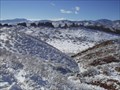
 view gallery view galleryNW7.4 km |  Storm Mountain Trail Storm Mountain Trail
in Offroad Trails Storm Mountain trail area posted by: KingJR location: Colorado date approved: 01/17/2006 last visited: never |
 view gallery view galleryNW7.7 km | Storm Mountain Cadastral Survery disk in U.S. Benchmarks Cadastral Survey Disk near Storm Mountain Summit posted by: KingJR location: Colorado date approved: 11/26/2005 last visited: never |
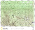
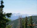
 W9 km |  Crosier Mountain Crosier Mountain
in Mountain Summits One of the small summits in this part of CO, but the views to the East and West are awesome. posted by: Tahosa and Sons location: Colorado date approved: 11/07/2005 last visited: 06/08/2008 |
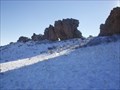
 view gallery view galleryW9 km |  Crosier Mountain Summit Register Crosier Mountain Summit Register
in Summit Registers The Croiser Mountain Summit Register can be found at 9,250ft above sea level, after a 4 mile hike in. posted by: Team Laxson location: Colorado date approved: 11/16/2008 last visited: 05/11/2010 |
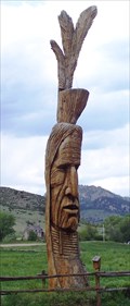 view gallery view galleryE10 km |  Peter Toth's Colorado "Redman" - Loveland, CO Peter Toth's Colorado "Redman" - Loveland, CO
in Roadside Attractions Peter Toth's Colorado "Redman" is preserved for a longer life.
posted by: Big B Bob location: Colorado date approved: 05/28/2009 last visited: 02/25/2018 |
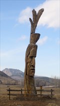 view gallery view galleryE10 km |  Redman - Loveland, Colorado Redman - Loveland, Colorado
in Whispering Giant Sculptures #31 of The Trail of the Whispering Giants, in a field west of Loveland posted by: ronjean location: Colorado date approved: 01/31/2009 last visited: 10/13/2016 |
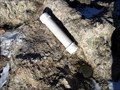
NW12.9 km | Crystal Mountain unknown U.S.G.S. Benchmark in U.S. Benchmarks Stumbled upon this benchmark while ATVing Crystal Mountain back in August. posted by: KingJR location: Colorado date approved: 11/25/2005 last visited: never |
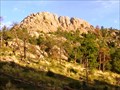
 view gallery view galleryE12.9 km |  Devils Backbone Devils Backbone
in Geological Devilish Locations A unique geological formation West of Loveland that resembles the spine of a dragon as it emerges from the ground. posted by: Tahosa and Sons location: Colorado date approved: 11/06/2005 last visited: 05/01/2013 |
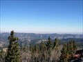
 view gallery view galleryE13.2 km |  The Keyhole The Keyhole
in Natural Arches One of the Local Landmarks of Northern Colorado, West of Loveland. From the arch one can look to the West and view Longs Peak and other areas. posted by: Tahosa and Sons location: Colorado date approved: 11/05/2005 last visited: 04/20/2016 |
 view gallery view galleryNW13.7 km |  Bulwark Ridge Trail Bulwark Ridge Trail
in Scenic Hikes A wonderful hike on top of Bulwark Ridge that takes you to the summit of South Signal Mountain. posted by: KingJR location: Colorado date approved: 07/03/2007 last visited: 05/11/2010 |
 view gallery view galleryE14.3 km | Devil's Backbone, Loveland, CO in Geological Devilish Locations A hiking trail leads along the spine. posted by: ronjean location: Colorado date approved: 03/30/2010 last visited: 08/28/2017 |
 view gallery view galleryNW15.3 km | Crystal Mountain 4x4 area in Offroad Trails This is the crystal mountain 4x4 area. posted by: KingJR location: Colorado date approved: 01/17/2006 last visited: never |
 view gallery view galleryNW15.6 km | Crystal Mountain in Mountain Summits Summit of Crystal Mountain, in Buckhorn Canyon - Larimer County, CO. posted by: KingJR location: Colorado date approved: 11/24/2005 last visited: never |
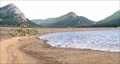 view gallery view galleryW15.6 km |  Olympus Dam, Estes Park, CO Olympus Dam, Estes Park, CO
in Water Dams Olympus Dam holds the water in Lake Estes, near Rocky Mtn National Park posted by: ronjean location: Colorado date approved: 06/17/2010 last visited: 09/25/2019 |
 view gallery view gallery NE15.8 km NE15.8 km
|  Horsetooth Mountain Web Cam Horsetooth Mountain Web Cam
in Web Cameras This is a webcam located in the parking lot adjacent to the trailhead for Horsetooth Mountain. posted by: Memfis Mafia location: Colorado date approved: 04/25/2016 last visited: never |
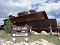 view gallery view galleryW15.8 km |  Noah's Ark-shaped Building - Estes Park, Colorado Noah's Ark-shaped Building - Estes Park, Colorado
in Odd-Shaped Buildings A stuffed animal shop with the most appropriate shape. posted by: Big B Bob location: Colorado date approved: 07/13/2009 last visited: 10/13/2016 |
|