 view gallery view gallery NE3.1 km NE3.1 km
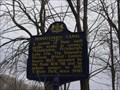
|   Pennsylvania Canal Pennsylvania Canal
in Pennsylvania Historical Markers Here come the mules again! posted by:  Gosffo Gosffo location: Pennsylvania date approved: 03/10/2007 last visited: 06/23/2013 |
 view gallery view galleryNE3.1 km | Martin Johnson Heade in Pennsylvania Historical Markers Why does a hummingbird hum, cause he doesn't know the words! posted by: Gosffo location: Pennsylvania date approved: 03/10/2007 last visited: 08/23/2010 |
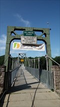 view gallery view galleryNE3.2 km |  Lumberville-Raven Rock Footbridge - Delaware River - Suspension Bridge Lumberville-Raven Rock Footbridge - Delaware River - Suspension Bridge
in Pedestrian Suspension Bridges This large pedestrian bridge spans the Delaware River and allows crossing between New Jersey and Pennsylvania posted by: miatabug location: New Jersey date approved: 07/21/2010 last visited: 07/27/2013 |
 view gallery view galleryNE3.4 km |  Delaware and Raritan Canal State Park - New Jersey Delaware and Raritan Canal State Park - New Jersey
in State/Provincial Parks The New Jersey Division of Parks and Forestry owns and maintains this greenway. Contact the D&R Canal at the Canal State Park office at 908-873-3050 posted by:  Math Teacher Math Teacher location: New Jersey date approved: 11/21/2007 last visited: 05/18/2012 |
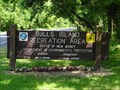 view gallery view galleryNE3.4 km |  Bull's Island Recreation Area - Lumberville, NJ Bull's Island Recreation Area - Lumberville, NJ
in Wikipedia Entries Bull's Island Recreation Area is located on Daniel Bray Highway (Rt. 29) in Hunterdon County, 7 miles north of Lambertville, N.J. The Bull's Island campground is the only area within the Delaware & Raritan Canal State Park where camping is allowed. posted by: Math Teacher location: New Jersey date approved: 11/21/2007 last visited: 05/17/2008 |
 view gallery view galleryNE3.4 km |  D&R Canal State Park - Your Passport to Adventure - Stockton, NJ D&R Canal State Park - Your Passport to Adventure - Stockton, NJ
in State Park Passport Locations This stamp can be had at Bull's Island Recreation Area which is part of the D&R Canal State Park. The New Jersey Division of Parks and Forestry owns and maintains this greenway. posted by: Math Teacher location: New Jersey date approved: 06/15/2009 last visited: 05/18/2012 |
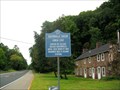 view gallery view galleryNE3.7 km |  Saxtonville Tavern - Stockton (Delaware Twp), NJ 08559 Saxtonville Tavern - Stockton (Delaware Twp), NJ 08559
in New Jersey Historical Markers Site of former Saxtonville Tavern on the Daniel Bray Highway at Raven Rock NJ. posted by: scornell1 location: New Jersey date approved: 09/23/2009 last visited: 07/27/2013 |
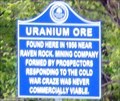 view gallery view galleryNE3.7 km | Uranium Ore - Raven Rock, NJ in New Jersey Historical Markers Uranium Ore-Found here in 1956 near Raven Rock. Mining company formed by prospectors responding to the cold war craze was never commercially viable. posted by: Don.Morfe location: New Jersey date approved: 07/09/2020 last visited: 10/22/2021 |
 view gallery view gallery E4.2 km E4.2 km
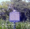
| Honey Hollow Watershed in Pennsylvania Historical Markers A 700-acre watershed, managed for agriculture; first in the nation to show that cooperative action, with federal technical assistance, can shape land use. posted by: Don.Morfe location: Pennsylvania date approved: 05/03/2020 last visited: 10/19/2021 |
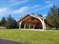 view gallery view gallery SW4.5 km SW4.5 km
|  Captain Connor Bednarzyk Memorial Amphitheater - Buckingham Township, PA, USA Captain Connor Bednarzyk Memorial Amphitheater - Buckingham Township, PA, USA
in Outdoor Amphitheaters This new Amphitheater is almost a bandshell, but it does lack sides. posted by: Lightnin Bug location: Pennsylvania date approved: 11/16/2023 last visited: never |
 view gallery view galleryE4.8 km |  Honey Hollow Watershed 1939-1969 - New Hope PA Honey Hollow Watershed 1939-1969 - New Hope PA
in Signs of History The Honey Hollow Watershed conservation site is the first small created watershed to be brought totally under water, soil, and wildlife conservation practices in the United States. posted by: Don.Morfe location: Pennsylvania date approved: 04/26/2020 last visited: 09/27/2021 |
 view gallery view gallerySW4.8 km | The Doan Gang in Pennsylvania Historical Markers It's all in the family! posted by: Gosffo location: Pennsylvania date approved: 03/10/2007 last visited: 11/12/2023 |
  SE5.1 km SE5.1 km
|  Porterhouse Brewpub Restaurant Porterhouse Brewpub Restaurant
in Brewpubs A great restaurant and brewpub located just across the street from Peddlers Village in Lahaska, PA. posted by: Gargoyle location: Pennsylvania date approved: 09/20/2005 last visited: never |
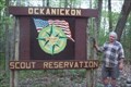 view gallery view gallery NW5.8 km NW5.8 km
|  Ockanickon Boy Scout Camp Ockanickon Boy Scout Camp
in Boy Scout Camps N 40° 26.040 W 075° 05.320
This Boy Scout Gateway is located near Ralp Stover State Park in PA. This camp is named after a Lenape Native American Tribal Leader. posted by: chstress53 location: Pennsylvania date approved: 10/21/2005 last visited: 10/23/2011 |
SE6 km |  The New Hope Winery The New Hope Winery
in Wineries No trip to New Hope would be complete without tasting a few delicious wines at the New Hope Winery! Set in a quaint 17th century barn, the New Hope Winery is quickly becoming a landmark in Bucks County. posted by: ganurse6 location: Pennsylvania date approved: 04/30/2006 last visited: 05/18/2012 |
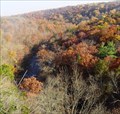 view gallery view galleryNW6.1 km |  High Rocks overlook High Rocks overlook
in Scenic Overlooks High rocks is a 200-foot sheer rock face overlooking an oxbow on the Tohickon Creek near the town of Point Pleasant Pennsylvania. posted by: dhmeiser location: Pennsylvania date approved: 08/02/2006 last visited: 10/15/2022 |
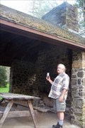 view gallery view galleryNW6.3 km |  Picnic Shelter at Ralph Stover State Park Picnic Shelter at Ralph Stover State Park
in Civilian Conservation Corps This Picnic shelter in Ralph Stover State Park was indeed built by the Civilian Conservation Corp. posted by: chstress53 location: Pennsylvania date approved: 10/21/2005 last visited: 07/27/2013 |
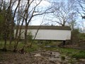
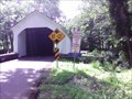
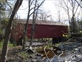 view gallery view galleryNW6.6 km |  Cabin Run Bridge - Smith's Corners, PA Cabin Run Bridge - Smith's Corners, PA
in U.S. National Register of Historic Places Cabin Run Bridge is appropriately named, crossing the Cabin Run near where it empties into the Tohickon Creek. posted by: Lightnin Bug location: Pennsylvania date approved: 04/18/2010 last visited: 02/15/2012 |
 view gallery view galleryNW6.6 km |  Cabin Run Bridge - Smith's Corners, PA Cabin Run Bridge - Smith's Corners, PA
in Covered Bridges Cabin Run Bridge is appropriately named, crossing the Cabin Run near where it empties into the Tohickon Creek. posted by: Lightnin Bug location: Pennsylvania date approved: 04/18/2010 last visited: 06/01/2013 |
 view gallery view gallery S6.8 km S6.8 km
|  Trinity Church Cemetery - Buckingham, PA Trinity Church Cemetery - Buckingham, PA
in Churchyard Cemeteries Cemetery next to Trinity Episcopal Church. Final resting place of famed anthropologist, Margaret Mead. posted by:  briansnat briansnat location: Pennsylvania date approved: 04/25/2008 last visited: 03/21/2011 |
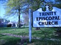
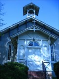 view gallery view galleryS6.8 km |  Trinity Episcopal Church - Buckingham, PA Trinity Episcopal Church - Buckingham, PA
in This Old Church Trinity Church was built in 1841. The original sanctuary is no longer used for regular worship but still stands on a corner of the property. posted by: briansnat location: Pennsylvania date approved: 04/25/2008 last visited: 09/02/2010 |
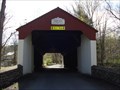
 view gallery view galleryNW6.8 km | Loux covered Bridge - Wismer, PA in Covered Bridges Loux Covered Bridge is on a hairpin turn in Carversville Road as it crosses Cabin Run. posted by: Lightnin Bug location: Pennsylvania date approved: 04/18/2010 last visited: 06/01/2013 |
 view gallery view galleryNW6.8 km | Loux Covered Bridge - Wismer, PA in U.S. National Register of Historic Places Loux Covered Bridge is on a hairpin turn in Carversville Road as it crosses Cabin Run. posted by: Lightnin Bug location: Pennsylvania date approved: 04/18/2010 last visited: 02/15/2011 |
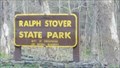 view gallery view galleryNW6.9 km | Ralph Stover State Park - Pipersville, PA in State/Provincial Parks Ralph Stover State Park is one of 121 state parks in the Pennsylvania state park system. posted by: Janila location: Pennsylvania date approved: 07/07/2018 last visited: 10/15/2022 |
 view gallery view galleryNW6.9 km | Carversville Road in Covered Bridges A beautiful old covered bridge on Carversville Road in Wismer, PA. posted by: Cachenstache location: Pennsylvania date approved: 06/24/2007 last visited: 06/01/2013 |
|