 view gallery view gallery N2.1 km N2.1 km
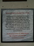
|   Bransford & McIntyre Store - Greenville, CA Bransford & McIntyre Store - Greenville, CA
in E Clampus Vitus Historical Markers An old general store in Greenville, California that now houses the Way Station Bar. posted by:  heringermr heringermr location: California date approved: 08/25/2009 last visited: 01/15/2010 |
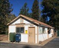
 view gallery view galleryN2.3 km |  Greenville, California 95947 Greenville, California 95947
in U.S. Post Offices The Greenville, California Post Office. posted by:  Volcanoguy Volcanoguy location: California date approved: 10/26/2017 last visited: 10/11/2016 |
 view gallery view gallery SE5 km SE5 km
| Crescent Mills, California 95934 in U.S. Post Offices The Crescent Mills, California Post Office. posted by: Volcanoguy location: California date approved: 10/26/2017 last visited: 10/11/2016 |
 view gallery view gallery NE7.4 km NE7.4 km
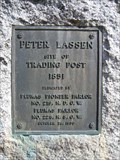
|  Peter Lassen Marker Peter Lassen Marker
in California Historical Markers California Historical Landmark #184 posted by: heringermr location: California date approved: 08/13/2007 last visited: 10/11/2016 |
 view gallery view gallery S10.6 km S10.6 km
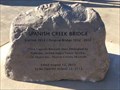
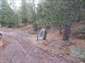
|  Spanish Creek Bridge Time Capsule — CA Spanish Creek Bridge Time Capsule — CA
in Time Capsules A time capsule at the Spanish Creek Bridge Overlook. posted by: Volcanoguy location: California date approved: 10/24/2017 last visited: 10/11/2016 |
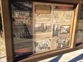 view gallery view galleryS10.6 km |  The Western Pacific - Spanish Creek Bridge Overlook, CA The Western Pacific - Spanish Creek Bridge Overlook, CA
in Signs of History History sign at the Spanish Creek Bridge Overlook. posted by: Volcanoguy location: California date approved: 10/18/2017 last visited: 10/11/2016 |
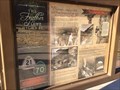 view gallery view galleryS10.6 km | The Feather River Highway - Spanish Creek Bridge Overlook, CA in Signs of History History sign at the Spanish Creek Bridge Overlook. posted by: Volcanoguy location: California date approved: 10/18/2017 last visited: 10/11/2016 |
 view gallery view galleryS10.6 km | Bridging The Feather River Canyon - Spanish Creek Bridge Overlook, CA in Signs of History History sign at the Spanish Creek Bridge Overlook. posted by: Volcanoguy location: California date approved: 10/18/2017 last visited: 10/11/2016 |
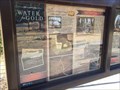 view gallery view galleryS10.6 km | Water for Gold - Spanish Creek Bridge Overlook, CA in Signs of History History sign at the Spanish Creek Bridge Overlook. posted by: Volcanoguy location: California date approved: 10/18/2017 last visited: 10/11/2016 |
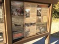
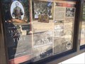 view gallery view galleryS10.6 km | Traveling through Time - Spanish Creek Bridge Overlook, CA in Signs of History History sign at the Spanish Creek Bridge Overlook. posted by: Volcanoguy location: California date approved: 10/18/2017 last visited: 10/11/2016 |
 view gallery view galleryS10.6 km | Men, Mules & Machinery - Spanish Creek Bridge Overlook, CA in Signs of History History sign at the Spanish Creek Bridge Overlook. posted by: Volcanoguy location: California date approved: 10/18/2017 last visited: 10/11/2016 |
 view gallery view gallery W10.8 km W10.8 km
| Seneca - Seneca, CA in E Clampus Vitus Historical Markers A marker for a remote Gold Rush town. Through 2013, there was a rustic bar open on weekends in the summer. posted by: heringermr location: California date approved: 08/28/2014 last visited: never |
 view gallery view gallery NW11.1 km NW11.1 km
| Canyondam, California 95923 in U.S. Post Offices The Canyondam, California Post Office. posted by: Volcanoguy location: California date approved: 10/26/2017 last visited: 10/11/2016 |
 view gallery view gallery SW13.2 km SW13.2 km
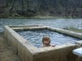
|  Woody's Hot Springs Woody's Hot Springs
in Hot Springs An informal hot springs on the Feather River near Twain, California. posted by: Squirreleen location: California date approved: 04/13/2009 last visited: 07/02/2011 |
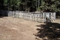 view gallery view galleryW15.6 km |  Miller Family Cemetery - Butt Valley Reservoir, California Miller Family Cemetery - Butt Valley Reservoir, California
in Abandoned Cemeteries This small family cemetery is located along the east shore of Butt Valley Reservior near Seneca, California. It contains the remains of the William H. Miller Family. posted by: Nitro929 location: California date approved: 09/03/2008 last visited: 08/06/2023 |
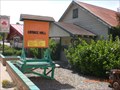 view gallery view galleryS20.6 km |  Feather River Grange #440 - Quincy, California Feather River Grange #440 - Quincy, California
in Grange Halls Serving the northern Sierra Nevada mountains. posted by: shadow101 location: California date approved: 07/09/2012 last visited: 06/02/2012 |
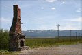 view gallery view galleryN22.5 km |  East of Westwood East of Westwood
in Lonely Chimneys About three miles east of the small town of Westwood, on California Highway 36, on the south side of the road. posted by: chaosmanor location: California date approved: 07/09/2010 last visited: 06/01/2011 |
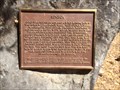
 view gallery view galleryN22.9 km | #678 - Lassen Emigrant Trail in California Historical Markers The Lassen Trail was in use during the California Gold Rush from 1848 to 1851. posted by: two bison location: California date approved: 05/12/2015 last visited: 08/10/2011 |
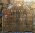 view gallery view gallerySW23.5 km | Rich Bar in California Historical Markers A plaque commemorating a gold rush camp along Highway 70 in the Feather River Canyon. posted by: heringermr location: California date approved: 08/20/2013 last visited: never |
 view gallery view galleryNW30.9 km | Dinky - Chester, California in E Clampus Vitus Historical Markers E Clampus Vitus Historical Marker in Chester, California. posted by: Volcanoguy location: California date approved: 11/21/2013 last visited: 09/18/2013 |
 view gallery view galleryNW30.9 km |  Eureka - Chester, California Eureka - Chester, California
in Locomotives Eureka, a small locomotive in Chester, California. posted by: Volcanoguy location: California date approved: 11/18/2013 last visited: 09/18/2013 |
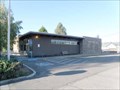 view gallery view galleryNW30.9 km | Chester, California 96020 in U.S. Post Offices The Chester, California Post Office. posted by: Volcanoguy location: California date approved: 11/27/2013 last visited: 09/18/2013 |
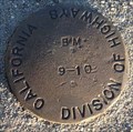 view gallery view galleryNW31.1 km |  CDH 9-10 - Chester, California CDH 9-10 - Chester, California
in U.S. Benchmarks California Division of Highways benchmark 9-10. posted by: Volcanoguy location: California date approved: 11/15/2013 last visited: 09/16/2013 |
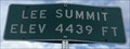 view gallery view gallerySE31.9 km |  Hwy 89 at Lee Summit - Elevation 4439 feet - California Hwy 89 at Lee Summit - Elevation 4439 feet - California
in Elevation Signs Elevation sign at Lee Summit on CA Hwy. 89. posted by: Volcanoguy location: California date approved: 10/17/2017 last visited: 10/10/2016 |
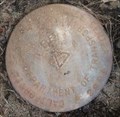 view gallery view gallerySE31.9 km | CDOT LEE - 2001 - California in U.S. Benchmarks California Dept of Transportation control point LEE. posted by: Volcanoguy location: California date approved: 10/18/2017 last visited: 10/10/2016 |
|