 view gallery view gallery SW6.3 km SW6.3 km
|   Zook and Roeker State Bank Zook and Roeker State Bank
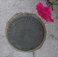
in U.S. Benchmarks Can be found on the lower right hand door frame. posted by:  Troop81 Troop81 location: Missouri date approved: 07/18/2008 last visited: 10/15/2021 |
 view gallery view gallery E7.6 km E7.6 km
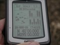
|  N40 W95 2.2 miles SW of Fillmore, Andrew County, Missouri, USA N40 W95 2.2 miles SW of Fillmore, Andrew County, Missouri, USA
in Confluence Spots Another corn field posted by:  txoilgas txoilgas location: Missouri date approved: 01/16/2009 last visited: 03/26/2006 |
 view gallery view gallery NW12.2 km NW12.2 km
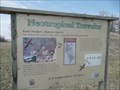
|  Bank Swallows - Mound City MO Bank Swallows - Mound City MO
in Flora and Fauna Information Signs There is a small protected area for Bank Swallows along US 159 about 4 miles south-southwest of Mound City, Missouri. posted by: PeterNoG location: Missouri date approved: 05/06/2010 last visited: 10/09/2021 |
 view gallery view gallery SE12.9 km SE12.9 km
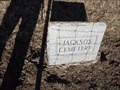
|  Jackson Cemetery - Andrew County MO Jackson Cemetery - Andrew County MO
in Worldwide Cemeteries This small Cemetery is on County Road 71 about 1.4 east of State Highway H or 1 mile west of County Road 70 in Andrew County, Missouri. posted by: PeterNoG location: Missouri date approved: 03/19/2012 last visited: 01/04/2012 |
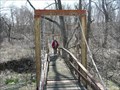 view gallery view gallerySE13.2 km |  WPA Bridge - US 59 - Missouri WPA Bridge - US 59 - Missouri
in Pedestrian Suspension Bridges This swinging bridge was built by the WPA sometime between 1935 and 1943. It's in a small park on US 59 about 6 miles west of Savannah. posted by: PeterNoG location: Missouri date approved: 04/13/2008 last visited: 11/04/2012 |
 view gallery view galleryNW14.5 km |  I-29 Southbound Mound City Rest Area I-29 Southbound Mound City Rest Area
in Highway Rest Areas Rest area Southbound I-29, 2 miles south of Route 118 and I-29, Mile Marker 82. posted by:  BruceS BruceS location: Missouri date approved: 09/26/2006 last visited: 06/04/2018 |
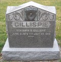 view gallery view galleryE17.7 km |  Benjamin B. Gillispie - Bennett Lane Cemetery - Rural Andrew County Benjamin B. Gillispie - Bennett Lane Cemetery - Rural Andrew County
in Woodmen of the World Grave Markers/Monuments This slab style Woodman headstone - of grey marble - is located in the Bennett Lane Cemetery. The Cemetery is on US 71 & County Road 151 posted by: iconions location: Missouri date approved: 02/09/2010 last visited: never |
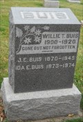 view gallery view galleryE17.7 km |  101 - Ida E. Buis - Bennett Lane Cemetery - Rural Andrew County, Missouri 101 - Ida E. Buis - Bennett Lane Cemetery - Rural Andrew County, Missouri
in Headstones of Centenarians This husband & wife headstone - of grey marble - is located in the Bennett Lane Cemetery. The Cemetery is on US 71 & County Road 151 posted by: iconions location: Missouri date approved: 02/09/2010 last visited: never |
 view gallery view gallerySW20.1 km |  Sparks Flea Market Sparks Flea Market
in Flea Markets Large biannual flea market. Free admission. More than 500 dealers. Mostly antiques. posted by: wardnkathy location: Kansas date approved: 09/02/2014 last visited: never |
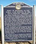 view gallery view gallery W21.1 km W21.1 km
|  Point of Beginning Point of Beginning
in Nebraska Historical Markers This marker, located on the Nebraska-Kansas border, commemorates the starting point of the base line survey done in 1855-56 to mark the 40th parallel boundary between the two states. posted by: NevaP location: Nebraska date approved: 11/15/2007 last visited: 02/27/2023 |
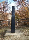 view gallery view galleryW21.1 km |  Point of Beginning of the Public Land Surveys of the Sixth Principal Meridian Point of Beginning of the Public Land Surveys of the Sixth Principal Meridian
in U.S. Historic Survey Stones and Monuments This monument marks the initial point of the 1855-56 survey of the border between the new territories of Kansas and Nebraska. posted by: NevaP location: Kansas date approved: 11/18/2007 last visited: 09/05/2020 |
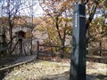 view gallery view galleryW21.1 km |  Survey monument -Point of Beginning Sixth Principal Meridian Survey monument -Point of Beginning Sixth Principal Meridian
in Guest Books This guestbook is at the 1855 monument marking the start of a survey line. posted by: NevaP location: Kansas date approved: 11/18/2007 last visited: 09/05/2020 |
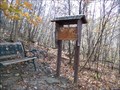 view gallery view galleryW21.1 km | Atchison-Nebraska railroad in Nebraska Historical Markers This is a handmade marker about the 19th century railroad that ran from Atchison, Kansas to Lincoln, Nebraska. posted by: NevaP location: Nebraska date approved: 11/18/2007 last visited: 09/05/2020 |
 view gallery view galleryE22.4 km |  No turtle crossing No turtle crossing
in Turtle Crossings Turtle crossing the street posted by: onetrapper location: Missouri date approved: 10/08/2005 last visited: never |
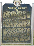 view gallery view galleryE23.3 km |  Andrew County Andrew County
in Missouri Historical Markers This Marker is on the north side of the Andrew County Courthouse located at 4th and Main Streets in Savannah, Mo. posted by: iconions location: Missouri date approved: 01/17/2011 last visited: never |
 view gallery view galleryE23.3 km |  Andrew County, Missouri Andrew County, Missouri
in People-Named Places Andrew County, Missouri is named for Andrew Jackson Davis, a St Louis Lawyer. Center of Waymark is located at the Andrew County Courthouse, a two-and-a-half Romanesque brick building located at 4th and Main Streets in Savannah, Missouri. posted by: iconions location: Missouri date approved: 06/13/2018 last visited: never |
 view gallery view galleryE23.3 km |  Andrew County Courthouse - Savannah, Missouri Andrew County Courthouse - Savannah, Missouri
in Wikipedia Entries The Andrew County Courthouse is located in Savannah, Missouri at 4th and Main Streets. It is a two=ans-a-half-story building of brick and stone construction with Romanesque stylistic elements. posted by: iconions location: Missouri date approved: 06/12/2018 last visited: never |
 view gallery view galleryE23.3 km |  Andrew County Courthouse Clock - Savannah, MO Andrew County Courthouse Clock - Savannah, MO
in Town Clocks The Andrew County Courthouse Clock is located atop the Courthouse in Savannah, Mo at 4th and Main Streets. posted by: iconions location: Missouri date approved: 01/17/2011 last visited: never |
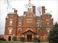 view gallery view galleryE23.3 km |  Andrew County Courthouse - Savannah, Missouri Andrew County Courthouse - Savannah, Missouri
in U.S. National Register of Historic Places The Andrew County Courthouse is located in Savannah, Mo at 4th and Main Streets in Savannah, Missouri. posted by: iconions location: Missouri date approved: 01/17/2011 last visited: never |
 view gallery view galleryE23.3 km |  Andrew County Courthouse - Savannah, Missouri Andrew County Courthouse - Savannah, Missouri
in Victorian Style Architecture The Andrew County Courthouse is located in Savannah, Missouri at 4th and Main Streets. It is a two=ans-a-half-story building of brick and stone construction with Romanesque stylistic elements. posted by: iconions location: Missouri date approved: 06/12/2018 last visited: never |
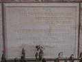 view gallery view galleryE23.3 km |  1898 - Andrew County Courthouse 1898 - Andrew County Courthouse
in Dated Buildings and Cornerstones The Andrew County Courthouse is located in Savannah, Mo at 4th and Main Streets. posted by: iconions location: Missouri date approved: 01/17/2011 last visited: never |
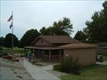
 view gallery view galleryE23.5 km |  Andrew County Courthouse - Savannah, MO Andrew County Courthouse - Savannah, MO
in Courthouses Courthouse located on the town square in Savannah, Missouri. posted by: wardnkathy location: Missouri date approved: 05/12/2009 last visited: 12/04/2010 |
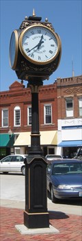 view gallery view galleryE23.5 km | Town Square Clock, Savannah, MO in Town Clocks Working clock on courthouse square. posted by: wardnkathy location: Missouri date approved: 05/12/2009 last visited: 12/04/2010 |
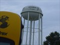 view gallery view galleryE24 km |  Savannah Savage Logo Savannah Savage Logo
in Water Towers Savannah High School Logo posted by: onetrapper location: Missouri date approved: 10/08/2005 last visited: 12/04/2010 |
 view gallery view gallery S25.3 km S25.3 km
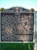
|  TROY TROY
in Kansas Historical Markers PONY EXPRESS IN TROY KANSAS posted by: GEO*Trailblazer 1 location: Kansas date approved: 10/20/2006 last visited: 09/19/2014 |
|