 view gallery view gallery NE2.1 km NE2.1 km
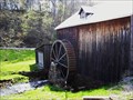
|   A Rural West Virgina Water Mill A Rural West Virgina Water Mill
in Water Mills Discovered this unused gem while on a waymarking adventure. A lucky find! posted by:  Algoma! Algoma! location: West Virginia date approved: 05/07/2008 last visited: never |
 view gallery view gallery E3.1 km E3.1 km
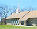
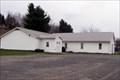
|  Faith United Methodist Church - Terra Alta, WV Faith United Methodist Church - Terra Alta, WV
in Methodist Churches The Faith United Methodist Church is located at 6639 Cranesville Road in rural Preston County, West Virginia posted by: outdoorboy34 location: West Virginia date approved: 02/16/2014 last visited: never |
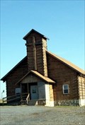
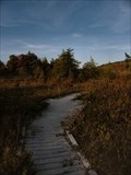 view gallery view galleryE4.8 km |  Boardwalk - Cranesville Subarctic Swamp Boardwalk - Cranesville Subarctic Swamp
in Non-Coastal Boardwalks This boardwalk crosses over the Cranesville Subarctic Swamp near the West Virginia and Maryland border. posted by:  miatabug miatabug location: West Virginia date approved: 10/04/2009 last visited: 09/22/2011 |
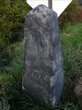 view gallery view galleryE5 km |  West Virginia / Maryland near Cranesville Swamp West Virginia / Maryland near Cranesville Swamp
in Border Crossings This old stone marker along the road to Cranesville Subarctic Swamp marks a crossing point between West Virginia and Maryland. posted by: miatabug location: West Virginia date approved: 10/04/2009 last visited: 03/03/2011 |
 view gallery view gallery W8.2 km W8.2 km
|  Virginia Iron Furnace Virginia Iron Furnace
in Iron Furnace Ruins Iron furnace off WV Route 26 posted by: wvcoalcat location: West Virginia date approved: 08/16/2005 last visited: 06/30/2010 |
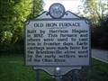 view gallery view galleryW8.2 km |  Old Iron Furnace Old Iron Furnace
in West Virginia Historical Markers Casting made here were used in the Brandonville stove used by settlers west of the Ohio River. posted by: Paintedwarrior location: West Virginia date approved: 09/09/2013 last visited: 09/14/2013 |
 view gallery view gallery S9.3 km S9.3 km
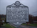
| Dr. Loomis' Grave in West Virginia Historical Markers Dr. Loomis sender of first aerial signals. posted by: Paintedwarrior location: West Virginia date approved: 10/30/2012 last visited: 10/22/2012 |
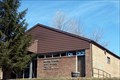
 view gallery view galleryS9.3 km |  Terra Alta Church of the Nazarene - Terra Alta, West Virginia Terra Alta Church of the Nazarene - Terra Alta, West Virginia
in Church of the Nazarene The Terra Alta Church of the Nazarene is located at 606 Brandonville Pike (near Terra Alta), Preston County, West Virginia posted by: outdoorboy34 location: West Virginia date approved: 03/19/2011 last visited: 03/06/2011 |
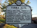 view gallery view galleryS10.1 km | Terra Alta in West Virginia Historical Markers A sign telling us about Terra Alta, WV. posted by: Paintedwarrior location: West Virginia date approved: 11/16/2011 last visited: 11/21/2011 |
 view gallery view galleryS10.1 km |  Terra Alta Assembly of God - Terra Alta, West Virginia Terra Alta Assembly of God - Terra Alta, West Virginia
in Assembly of God Churches The Terra Alta Assembly of God Church is located on Main Street in the Town of Terra Alta, Preston County, West Virginia posted by: outdoorboy34 location: West Virginia date approved: 03/19/2011 last visited: 11/04/2011 |
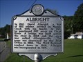 view gallery view gallery SW10.1 km SW10.1 km
| Albright / Albright Family in West Virginia Historical Markers A doubled sided sign telling how the town of Albright got its name. posted by: Paintedwarrior location: West Virginia date approved: 09/09/2013 last visited: 09/14/2013 |
 view gallery view galleryS10.3 km |  Terra Alta Public Library - Terra Alta, West Virginia Terra Alta Public Library - Terra Alta, West Virginia
in Libraries The Terra Alta Public Library is located in the Terra Alta Municipal Building, 701 East State Street (WV Rte.7), Town of Terra Alta, Preston County, West Virginia posted by: outdoorboy34 location: West Virginia date approved: 03/19/2011 last visited: 11/04/2011 |
 view gallery view galleryS10.3 km |  Terra Alta, West Virginia Terra Alta, West Virginia
in City and Town Halls The Terra Alta Town Hall is located at 701-B East State Avenue (WV Rte. 7), Town of Terra Alta, Preston County, West Virginia. posted by: outdoorboy34 location: West Virginia date approved: 03/19/2011 last visited: 11/04/2011 |
 view gallery view galleryS10.5 km |  Terra Alta, West Virginia - 26764 Terra Alta, West Virginia - 26764
in U.S. Post Offices The Terra Alta Post Office is located at 103 North 4th Street in the town of Terra Alta, Preston County, West Virginia. posted by: outdoorboy34 location: West Virginia date approved: 03/19/2011 last visited: 03/06/2011 |
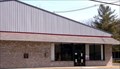
 view gallery view galleryS10.5 km |  Terra Alta Ambulance Squad - Terra Alta, West Virginia Terra Alta Ambulance Squad - Terra Alta, West Virginia
in Paramedic Stations The Terra Alta Ambulance Station is located at 1127 East State Avenue (WV Rte. 7) in the Town Of Terra Alta, Preston County, West Virginia posted by: outdoorboy34 location: West Virginia date approved: 03/19/2011 last visited: 03/06/2011 |
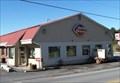 view gallery view galleryS10.5 km |  Dairy Queen - E. State St. (WV Route 7) - Terra Alta, West Virginia Dairy Queen - E. State St. (WV Route 7) - Terra Alta, West Virginia
in Dairy Queen Restaurants This Dairy Queen is located at 1200 East State Avenue (WV Rte. 7), town of Terra Alta, Preston County, West Virginia posted by: outdoorboy34 location: West Virginia date approved: 03/19/2011 last visited: 03/06/2011 |
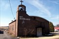 view gallery view galleryS10.6 km |  Saint Edward the Confessor Mission - Terra Alta, West Virginia Saint Edward the Confessor Mission - Terra Alta, West Virginia
in Roman Catholic Churches The Saint Edward the Confessor Mission is located along WV Route 7 East in the town of Terra Alta, Preston County,West Virginia. posted by: outdoorboy34 location: West Virginia date approved: 03/19/2011 last visited: 03/07/2011 |
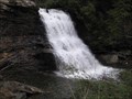 view gallery view galleryE11.1 km |  Muddy Creek Falls Muddy Creek Falls
in Waterfalls Highest waterfall in Maryland. posted by: wjl2375 location: Maryland date approved: 04/05/2006 last visited: 07/28/2022 |
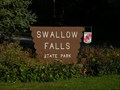
 view gallery view galleryE11.1 km |  Swallow Falls State Park - Oakland MD Swallow Falls State Park - Oakland MD
in Wikipedia Entries The state park features Maryland's highest free-falling waterfall, the 53-foot (16 m) Muddy Creek Falls. The park is notable for its stand of old hemlock trees, some more than 300 years old, "the last stand of its kind in Maryland." posted by: Don.Morfe location: Maryland date approved: 07/27/2022 last visited: 07/28/2022 |
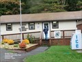 view gallery view galleryE11.1 km |  Swallow Falls State Park Office - Oakland, MD Swallow Falls State Park Office - Oakland, MD
in Ranger Stations The Ranger Station for Swallow Falls State Park is located at 2470 Maple Grove Road, Oakland MD 21550. Muddy Falls at 60 feet is the highest free-falling waterfall in Maryland. posted by: Don.Morfe location: Maryland date approved: 12/26/2020 last visited: 11/02/2021 |
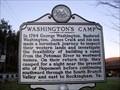 view gallery view galleryS11.1 km | Washington's Camp in West Virginia Historical Markers A sign telling us what George Washington was doing before and after he camped here. posted by: Paintedwarrior location: West Virginia date approved: 11/16/2011 last visited: 11/21/2011 |
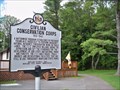 view gallery view galleryE11.1 km |  Civilian Conservation Corps 1933-1942 - Swallow Falls State Park, MD Civilian Conservation Corps 1933-1942 - Swallow Falls State Park, MD
in Maryland Historical Markers A brief history of the Civilian Conservation Corps and its impact on Maryland State Parks. posted by: cldisme location: Maryland date approved: 07/28/2013 last visited: 07/28/2022 |
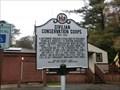 view gallery view galleryE11.1 km |  Civilian Conservation Corps 1933-1942 - Swallow Falls State Park, MD Civilian Conservation Corps 1933-1942 - Swallow Falls State Park, MD
in Civilian Conservation Corps A Maryland Historical Marker is located in the Ranger office parking lot in Swallow Falls State Park. It is titled "CIVILIAN CONSERVATION CORPS
1933-1942". A small sign is on the office "CCC Office 1933-1935". posted by: Don.Morfe location: Maryland date approved: 10/16/2022 last visited: 10/16/2022 |
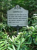 view gallery view galleryE11.1 km | Campsite in Maryland Historical Markers Located in Swallow Falls State Park. posted by: flyingmoose location: Maryland date approved: 07/25/2006 last visited: 07/28/2022 |
 view gallery view gallery SE11.1 km SE11.1 km
|  Swallow Falls State Park - Oakland, Maryland Swallow Falls State Park - Oakland, Maryland
in State/Provincial Parks Swallow Falls State Park is home to Maryland's tallest waterfall. posted by: miatabug location: Maryland date approved: 10/17/2009 last visited: 07/28/2022 |
|