 view gallery view gallery SE1.8 km SE1.8 km
|   Kokomo Memorial - 10,618 Feet - Colorado Kokomo Memorial - 10,618 Feet - Colorado
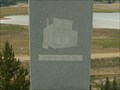
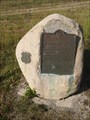
in Elevation Signs On Highway 91 southbound, a granite pedestal stands commemorating the valley where the towns of Robinson, Kokomo and Recen stood. posted by:  94RedRover 94RedRover location: Colorado date approved: 08/10/2009 last visited: 08/31/2017 |
 view gallery view gallerySE1.8 km |  Kokomo, Colorado Kokomo, Colorado
in American Guide Series On Highway 91 southbound, a granite pedestal stands commemorates the valley where the towns of Robinson, Kokomo and Recen stood. posted by: 94RedRover location: Colorado date approved: 08/23/2009 last visited: 08/31/2017 |
 view gallery view gallerySE1.8 km |  Kokomo and Recen - Colorado Kokomo and Recen - Colorado
in Ghost Towns On Highway 91 southbound, a granite pedestal stands commemorates the valley where the towns of Robinson, Kokomo and Recen stood. posted by: 94RedRover location: Colorado date approved: 08/24/2009 last visited: 08/31/2017 |
 view gallery view gallery S3.5 km S3.5 km
|  Valley of Ghosts ~ Lake County, Colorado Valley of Ghosts ~ Lake County, Colorado
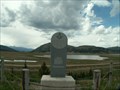
in Colorado Historical Markers This Historical Marker is located in a turnout on the northeast side of Colorado Highway 91 about 13 miles north of Leadville, Colorado. posted by:  brwhiz brwhiz location: Colorado date approved: 02/14/2013 last visited: never |
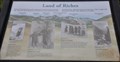
 view gallery view galleryS3.5 km | Land of Riches ~ Lake County, Colorado in Colorado Historical Markers This Historical Marker is located in a turnout on the northeast side of Colorado Highway 91 about 13 miles north of Leadville, Colorado. posted by: brwhiz location: Colorado date approved: 02/14/2013 last visited: never |
 view gallery view galleryS3.5 km |  First Lighted Ski Slopes in America First Lighted Ski Slopes in America
in First of its Kind The first lighted ski slopes in America were at Climax, Colorado. The slopes have long since disappeared into the open pit molybdenum mine that also swallowed up the town. posted by: brwhiz location: Colorado date approved: 02/13/2013 last visited: never |
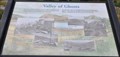
 view gallery view galleryS3.5 km |  Land of Riches Orientation Table Land of Riches Orientation Table
in Orientation Tables This interpretive sign orienting you to six high points of the terrain in the distance is located in a turnout on the northeast side of Colorado Highway 91 about 13 miles north of Leadville, Colorado. posted by: brwhiz location: Colorado date approved: 02/14/2013 last visited: never |
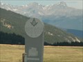
 view gallery view galleryS5.5 km | Fremont Pass - Lake County, Colorado in Colorado Historical Markers This marker explores both the location of Fremont Pass and the Louisiana Purchase. posted by: Outspoken1 location: Colorado date approved: 09/03/2017 last visited: never |
 view gallery view galleryS5.5 km | Fremont Pass, Lake County, Colorado. 11,316' in Elevation Signs This historic marker also documents the elevation of the pass. posted by: Outspoken1 location: Colorado date approved: 09/03/2017 last visited: never |
 view gallery view galleryS5.5 km |  Fremont Pass - Lake County, Colorado, USA Fremont Pass - Lake County, Colorado, USA
in Watershed Markers and Monuments This marker is found atop Fremont Pass and denotes the US Continental Divide that is the watershed of the Arkansas and Blue River drainages. posted by: Outspoken1 location: Colorado date approved: 01/20/2018 last visited: 06/07/2021 |
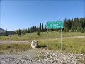 view gallery view galleryS5.5 km | Fremont Pass, Lake County, Colorado. 11,316' in Elevation Signs Department of Redundancy Department - both the road sign and historic marker document the elevation. posted by: Outspoken1 location: Colorado date approved: 09/03/2017 last visited: never |
 view gallery view gallery E8.2 km E8.2 km
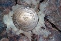
|  Quandary Peak Benchmark Quandary Peak Benchmark
in U.S. Benchmarks This benchmark is on top of a 14,265 foot tall mountain in the Ten Mile/Mosquito Range of the Rocky Mountains. posted by: DrPowercat location: Colorado date approved: 09/05/2009 last visited: 11/20/2022 |
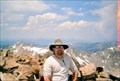 view gallery view galleryE8.4 km |  Quandary Peak Quandary Peak
in Mountain Summits Quandary Peak is south of Breckenridge in the Tenmile/Mosquito range of the Rocky Mountains. It is the 13th highest point in Colorado and the highest point in Summit county, Colorado. posted by: DrPowercat location: Colorado date approved: 09/07/2009 last visited: 06/20/2008 |
 view gallery view galleryE8.4 km |  Highest Point in Summit County, Colorado (Quandary Peak) Highest Point in Summit County, Colorado (Quandary Peak)
in Geographic High Points This is the 13th highest point in Colorado and it is located south of Breckenridge in the Tenmile/Mosquito range of the Rocky Mountains. posted by: DrPowercat location: Colorado date approved: 09/06/2009 last visited: never |
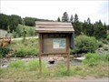 view gallery view gallery N9.2 km N9.2 km
|  Union Creek Trailhead - Copper Mountain, CO Union Creek Trailhead - Copper Mountain, CO
in Hiking and walking trailheads One of the trailheads on the Vail Pass Trail; part of the Summit County Trail system. posted by: Outspoken1 location: Colorado date approved: 08/07/2010 last visited: never |
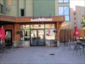
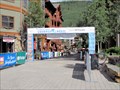
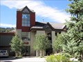 view gallery view galleryN9.3 km |  Copper Conference Center - Copper Mountain, CO Copper Conference Center - Copper Mountain, CO
in Convention Centers Conference/convention Center at Copper Mountain, Colorado, USA posted by: Outspoken1 location: Colorado date approved: 02/01/2011 last visited: never |
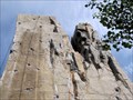 view gallery view galleryN9.5 km |  The Wall - Copper Mountain, CO The Wall - Copper Mountain, CO
in Artificial Climbing Walls Climbing wall in west Copper Mountain resort area posted by: Outspoken1 location: Colorado date approved: 08/11/2010 last visited: never |
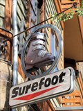 view gallery view galleryN9.5 km |  Surefoot Ski Boot - Copper Mountain, CO Surefoot Ski Boot - Copper Mountain, CO
in 3 Dimensional Art Over-sized alpine ski boot advertises the store's main product posted by: Outspoken1 location: Colorado date approved: 08/07/2010 last visited: 04/09/2012 |
 view gallery view galleryN9.5 km |  Miniature Golf - Copper Mountain, CO Miniature Golf - Copper Mountain, CO
in Miniature Golf Small miniature gold course in central Copper Mountain posted by: Outspoken1 location: Colorado date approved: 02/02/2011 last visited: never |
 view gallery view galleryN9.5 km |  Pizza Carlo - Copper Mountain, CO Pizza Carlo - Copper Mountain, CO
in Independent Pizza Restaurants New York-style pizza restaurant located in central Copper Mountain posted by: Outspoken1 location: Colorado date approved: 08/05/2011 last visited: never |
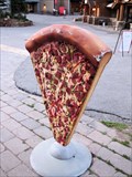 view gallery view galleryN9.5 km | Pizza Carlo - Copper Mountain, CO in 3 Dimensional Art New York-style pizza restaurant located in central Copper Mountain posted by: Outspoken1 location: Colorado date approved: 08/05/2011 last visited: 04/09/2012 |
 view gallery view galleryN9.5 km |  Checkers - Copper Mountain, CO Checkers - Copper Mountain, CO
in Giant Board Games Checker board in central Copper Mountain, CO posted by: Outspoken1 location: Colorado date approved: 08/04/2010 last visited: 04/09/2012 |
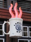 view gallery view galleryN9.5 km |  Camp Hale Coffee Shop - Copper Mountain, CO Camp Hale Coffee Shop - Copper Mountain, CO
in Artistic Neon Lights This lovely neon sign provides visitors the cue that hot beverages may be found inside posted by: Outspoken1 location: Colorado date approved: 08/05/2011 last visited: 04/09/2012 |
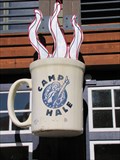 view gallery view galleryN9.5 km | Camp Hale Coffee Shop - Copper Mountain, CO in 3 Dimensional Art This lovely 3D cup provides visitors the cue that hot beverages may be found inside posted by: Outspoken1 location: Colorado date approved: 08/05/2011 last visited: 04/09/2012 |
 view gallery view galleryN9.5 km |  Courage Classic - Copper Mountain, CO Courage Classic - Copper Mountain, CO
in Festivals Annual celebration, conference and fund-raiser for Denver's Children's Hospital posted by: Outspoken1 location: Colorado date approved: 02/01/2011 last visited: never |
|