 view gallery view gallery E8.4 km E8.4 km
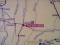
|   You Are Here in Kiowa, CO You Are Here in Kiowa, CO
in 'You Are Here' Maps You Are Here in the town of Kiowa on the eastern plains of Colorado. posted by:  condor1 condor1 location: Colorado date approved: 04/26/2010 last visited: 06/01/2012 |
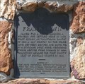
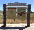
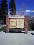 view gallery view galleryE8.4 km |  Trail Under Seige - Kiowa, CO Trail Under Seige - Kiowa, CO
in Colorado Historical Markers This Historical Marker sits along CO Hwy 86 (north side) adjacent to the Historical Elbert County Courthouse. posted by: condor1 location: Colorado date approved: 07/11/2010 last visited: 06/01/2012 |
 view gallery view gallery NW9 km NW9 km
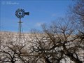
|  Aermotor Windmill Aermotor Windmill
in Windmills Working Aermotor steel tower windmill posted by: IHbinders location: Colorado date approved: 11/05/2011 last visited: 03/06/2021 |
 view gallery view gallery S10 km S10 km
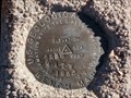
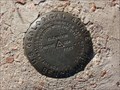
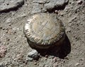
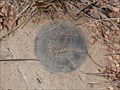
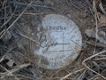
|  4 A.T.W - Elbert County, Colorado 4 A.T.W - Elbert County, Colorado
in U.S. Benchmarks USGS Benchmark northwest of Elbert, Colorado. posted by:  Tom.dog Tom.dog location: Colorado date approved: 12/14/2013 last visited: never |
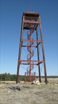 view gallery view galleryS15 km |  Kimsey Tower - Elbert County, CO Kimsey Tower - Elbert County, CO
in Citizen Memorials The Kimsey Tower is located on the grounds of the Peaceful Valley Scouts Ranch. posted by: condor1 location: Colorado date approved: 03/07/2011 last visited: 03/06/2011 |
 view gallery view gallery SW15.1 km SW15.1 km
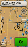
|  The "Baker" Pattern The "Baker" Pattern
in GPS Tracklog Art The Baker pattern was used by the US Navy to train pilots during WWII and is still useful today as an exercise to develop and maintain instrument proficiency. posted by: IJAdventures location: Colorado date approved: 01/08/2012 last visited: never |
 view gallery view gallerySW15.6 km | TT 3B (AA3438) - Douglas County, Colorado in U.S. Benchmarks A USGS benchmark located at the intersection of E Cherry Creek Road and Steele Avenue. posted by: Tom.dog location: Colorado date approved: 11/16/2022 last visited: never |
 view gallery view gallery W16.9 km W16.9 km
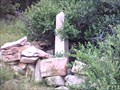
|  Conrad Moschel - Douglas County, CO Conrad Moschel - Douglas County, CO
in Out of Place Graves Here Lies Conrad Moschel - This Out-of-Place marker is buried (Ha Ha), in the Colorado back country. posted by: condor1 location: Colorado date approved: 08/10/2009 last visited: 04/26/2013 |
 view gallery view galleryW17.1 km | Castlewood Canyon Dam in U.S. Benchmarks Located on top of the east side of the Castlewood Canyon Dam ruins inside Colorado's Castlewood Canyon State Park. posted by: Rail Fan location: Colorado date approved: 06/18/2008 last visited: 05/03/2014 |
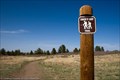
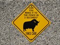 view gallery view galleryW17.9 km |  Yaks Are Fast - Castle Rock, CO Yaks Are Fast - Castle Rock, CO
in Unusual Signs This sign is located at the entrance to the "Organic Yak Farm" about 2 miles west of State Hwy 83 along Lake Gulch Rd. and about 10 miles southeast of Castlerock, CO posted by: condor1 location: Colorado date approved: 08/02/2009 last visited: 04/26/2013 |
 view gallery view galleryNW18.3 km | Franktown - Franktown CO in Colorado Historical Markers This Colorado Historical Marker is in a small pullout on Hwy 83 about 700 feet south of Hwy 86 in Franktown, Colorado. posted by: PeterNoG location: Colorado date approved: 12/12/2011 last visited: 05/07/2019 |
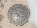
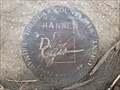 view gallery view gallerySW19.6 km | HANNEN (AA3416) - Douglas County, Colorado in U.S. Benchmarks A Douglas County GIS Primary Control Monument in the southwest corner of the intersection of Greenland Road and Dahlberg Road. posted by: Tom.dog location: Colorado date approved: 04/08/2024 last visited: never |
 view gallery view galleryNW19.8 km |  Pikes Peak Grange #163, Franktown, CO Pikes Peak Grange #163, Franktown, CO
in Grange Halls The Grange between Colorado Springs and Denver posted by: ronjean location: Colorado date approved: 06/20/2010 last visited: 09/22/2021 |
 view gallery view galleryNW19.8 km | History of Franktown/Granger Movement Timber, Douglas County, Co in Colorado Historical Markers Located in front of the Historic Grange Hall just 1 mile north of Franktown, Co along the west side of CO Hwy 83. posted by: condor1 location: Colorado date approved: 07/17/2015 last visited: 07/17/2015 |
 view gallery view galleryW21.7 km | FELLHAUER (AA3412) - Douglas County, Colorado in U.S. Benchmarks Douglas County GIS Primary Control Monument located at a prominent bend in Upper Lake Gulch Road. posted by: Tom.dog location: Colorado date approved: 10/30/2022 last visited: never |
 view gallery view galleryW21.7 km |  Mitchell Creek Canyon Trail - Castle Rock, CO Mitchell Creek Canyon Trail - Castle Rock, CO
in Scenic Hikes A natural surface trail with beautiful views nestled in a canyon near the town of Castle Rock, CO. posted by: IJAdventures location: Colorado date approved: 04/29/2012 last visited: 04/30/2014 |
 view gallery view galleryW22.2 km |  Chuck's Loop Trailhead at Gateway Mesa Open Space - Castle Rock, CO Chuck's Loop Trailhead at Gateway Mesa Open Space - Castle Rock, CO
in Hiking and walking trailheads A 1.8 mile loop on a mesa between Castle Rock and Franktown. posted by: IJAdventures location: Colorado date approved: 04/28/2012 last visited: 07/03/2015 |
 view gallery view galleryNW22.5 km |  Fonder Cemetery - Douglas County, CO Fonder Cemetery - Douglas County, CO
in Worldwide Cemeteries Fonder Cemetery - part of the Douglas County CO Historic sites. It was named after Hubert and Miriam Fonder. posted by: condor1 location: Colorado date approved: 04/03/2013 last visited: 06/22/2016 |
 view gallery view galleryS22.9 km | 2 A.T.W - El Paso County, Colorado in U.S. Benchmarks USGS Benchmark in Northern El Paso County, Colorado. posted by: Tom.dog location: Colorado date approved: 12/11/2013 last visited: never |
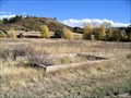 view gallery view galleryW23.7 km |  Civilian Conservation Corps Camp near Castle Rock, CO Civilian Conservation Corps Camp near Castle Rock, CO
in Civilian Conservation Corps Civilian Conservation Corps Camp near Castle Rock, CO posted by: Outspoken1 location: Colorado date approved: 12/31/2007 last visited: 04/30/2014 |
 view gallery view galleryW23.7 km | Civilian Conservation Corps (CCC) Camp near Castle Rock, CO in Colorado Historical Markers Former site of CCC camp in the 1930s located near Castle Rock posted by: Outspoken1 location: Colorado date approved: 12/31/2007 last visited: 04/30/2014 |
 view gallery view gallerySW24.5 km | 4.153034 - Douglas County, Colorado in U.S. Benchmarks Douglas County GIS Secondary Control Monument on Jones Rd. posted by: Tom.dog location: Colorado date approved: 12/22/2013 last visited: never |
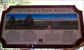 view gallery view galleryNW24.8 km |  Front Range Lookout Orientation Table - Parker, CO Front Range Lookout Orientation Table - Parker, CO
in Orientation Tables This group of 3 panels outline the Front Range as seen from Parker and give some of the local area history. posted by: IJAdventures location: Colorado date approved: 06/29/2012 last visited: 09/09/2017 |
 view gallery view galleryNW24.8 km |  Coin-Op Binoculars: Front Range Lookout - Parker, CO Coin-Op Binoculars: Front Range Lookout - Parker, CO
in Coin-Op Binoculars Coin operated binoculars located in the Idyllwilde subdivision of Parker with beautiful views of the Colorado Front Range. posted by: IJAdventures location: Colorado date approved: 06/25/2012 last visited: 04/16/2014 |
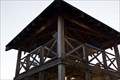 view gallery view galleryNW24.8 km |  Front Range Lookout - Parker, CO Front Range Lookout - Parker, CO
in Look-Out Towers A wooden lookout tower in the Idyllwilde community with views of Denver and the Front Range. posted by: IJAdventures location: Colorado date approved: 06/26/2012 last visited: 07/14/2019 |
|