 view gallery view gallery S2.6 km S2.6 km
|   Wheatland Spring Farm + Brewery - Waterford, Virginia Wheatland Spring Farm + Brewery - Waterford, Virginia
in Breweries Rural Brewery located along John Wolford Road near the intersection of Grace Place and Buroak Drive. posted by:  flyingmoose flyingmoose location: Virginia date approved: 09/13/2022 last visited: never |
 view gallery view gallery W5.1 km W5.1 km
|  Breaux Vineyards - Purcellville, Virginia Breaux Vineyards - Purcellville, Virginia
in Wineries Located on the northbound side of Harpers Ferry Road. posted by: flyingmoose location: Virginia date approved: 07/15/2021 last visited: never |
 view gallery view gallery SW5.1 km SW5.1 km
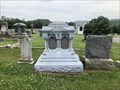
|  Jenkins - Hillsboro, Virginia Jenkins - Hillsboro, Virginia
in Zinc Headstones Located in the northern section of the cemetery to the east of the entrance road. posted by: flyingmoose location: Virginia date approved: 06/12/2021 last visited: never |
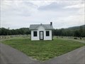 view gallery view gallerySW5.3 km |  Hillsboro Cemetery - Hillsboro, Virginia Hillsboro Cemetery - Hillsboro, Virginia
in Cemetery Chapels This Chapel sits at the center of the main cemetery entry road. posted by: flyingmoose location: Virginia date approved: 06/30/2021 last visited: never |
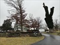
 view gallery view galleryW5.6 km |  John W. Mobberly - Purcellville, Virginia John W. Mobberly - Purcellville, Virginia
in Civil War Discovery Trail Sites Located 500 feet within the entrance to Breaux Vineyards, there is a small space to pull off. posted by: flyingmoose location: Virginia date approved: 09/03/2021 last visited: never |
 view gallery view gallery SE6 km SE6 km
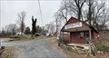
|  Bond Street Barn - Waterford, Virginia Bond Street Barn - Waterford, Virginia
in Painted Barn Quilts A quilt on the side of a barn in Waterford. posted by: flyingmoose location: Virginia date approved: 10/20/2020 last visited: never |
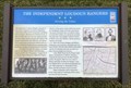 view gallery view gallery NE6.3 km NE6.3 km
| The Independant Loudoun Rangers - Lovettsville, Virginia in Civil War Discovery Trail Sites Located within the Lovettsville Town Square. posted by: flyingmoose location: Virginia date approved: 06/02/2023 last visited: never |
 view gallery view gallery NW7.1 km NW7.1 km
|  Christian Community at St Paul's - Purcellville, Virginia Christian Community at St Paul's - Purcellville, Virginia
in Country Churches Located on the southbound side of Harpers Ferry Road posted by: flyingmoose location: Virginia date approved: 06/10/2021 last visited: never |
 view gallery view gallery N7.2 km N7.2 km
|  Georges Mill Bed and Breakfast - Lovettsville, Virginia Georges Mill Bed and Breakfast - Lovettsville, Virginia
in Bed and Breakfast A Bed and Breakfast on a historical farm at the intersection of Georges Mill Road and Irish Corner Road. posted by: flyingmoose location: Virginia date approved: 01/26/2023 last visited: never |
 view gallery view galleryN7.2 km |  Georges Mill Farm - Lovettsville, Virginia Georges Mill Farm - Lovettsville, Virginia
in Century Farms A historical farm located at the intersection of Georges Mill Road and Irish Corner Road. posted by: flyingmoose location: Virginia date approved: 01/25/2023 last visited: never |
 view gallery view galleryN7.2 km |  Georges Mill - Lovettsville, Virginia - Population 17 Georges Mill - Lovettsville, Virginia - Population 17
in Population Signs A historical farm with a population sign above their shop on Georges Mill Road and Irish Corner Road. posted by: flyingmoose location: Virginia date approved: 01/25/2023 last visited: never |
 view gallery view galleryN7.2 km |  Georges Mill Farm - Lovettsville, Virginia Georges Mill Farm - Lovettsville, Virginia
in Dairy Creameries A historical farm located at the intersection of Georges Mill Road and Irish Corner Road. posted by: flyingmoose location: Virginia date approved: 01/26/2023 last visited: never |
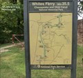 view gallery view gallerySW8.7 km |  Chesapeake and Ohio Canal National Historical Park-Whites Ferry- mile 35.5 - Dickerson MD Chesapeake and Ohio Canal National Historical Park-Whites Ferry- mile 35.5 - Dickerson MD
in National Parks of the World Whites Ferry Chesapeake and Ohio canal and towpath is dedicated to Justice William O. Douglas of White Ferry. This canal is located at mile 35.5 of a total of 184.5 miles. posted by:  Don.Morfe Don.Morfe location: Maryland date approved: 07/27/2022 last visited: 07/26/2022 |
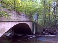 view gallery view gallerySW8.7 km |  Piney Run River Gauge Piney Run River Gauge
in River Gauges River gauge on a small creek feeding the Potomac posted by: alynx location: Virginia date approved: 10/20/2014 last visited: never |
 view gallery view galleryNW9.2 km |  Virginia/West Virginia at Keys Gap, VA-9/WV-9 Virginia/West Virginia at Keys Gap, VA-9/WV-9
in Border Crossings Parking is available immediately nearby for the Appalachian Trail, which you can use to stop and safely take your logging photos. posted by: hzoi location: Virginia date approved: 01/09/2022 last visited: 01/09/2022 |
 view gallery view galleryNW9.2 km |  Jefferson County/State of Virginia Jefferson County/State of Virginia
in West Virginia Historical Markers This historical marker is titled Jefferson County on one side and State of Virginia on the other. It is located along West Virginia State Route 9 in Jefferson County, West Virginia, just across the border from Virginia. posted by: Marine Biologist location: West Virginia date approved: 08/13/2008 last visited: 01/09/2022 |
 view gallery view galleryNW9.2 km |  AT at Keys Gap - West Virginia AT at Keys Gap - West Virginia
in Appalachian Trail This AT sign is located is located at Keys (aka Keyes) Gap on West Virginia State Route 9 in Jefferson County, West Virginia. posted by: Marine Biologist location: West Virginia date approved: 08/13/2008 last visited: 01/09/2022 |
 view gallery view galleryNE9.2 km |  Amanogawa - Baltimore, MD Amanogawa - Baltimore, MD
in Satellite Imagery Oddities bstract sculpture composed of 5 marble elements, including a central oval shape encircled by a strip of stainless steel and encrusted by 2 piers. 4 other smaller elements are before the larger one. All elements include rough and smooth stone. posted by: Math Teacher location: Maryland date approved: 08/13/2013 last visited: 10/09/2010 |
 view gallery view galleryNW9.3 km |  Blue Ridge Spring House - Purcellville, VA Blue Ridge Spring House - Purcellville, VA
in Spring Houses This springhouse was originally part of a historic farm but now is on the property of the Blue Ridge Center for Environmental Stewardship. posted by: dkestrel location: Virginia date approved: 11/08/2016 last visited: never |
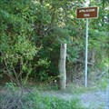
 view gallery view galleryNW9.8 km |  Keyes Gap Keyes Gap
in Wikipedia Entries A historical marker about Keyes Gap is located on West Virginia State Route 9 in Jefferson County, West Virginia. posted by: Marine Biologist location: West Virginia date approved: 08/10/2008 last visited: 01/09/2022 |
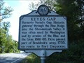 view gallery view galleryNW9.8 km | Keyes Gap in West Virginia Historical Markers A historical marker about Keyes Gap is located on West Virginia State Route 9 in Jefferson County, West Virginia. posted by: Marine Biologist location: West Virginia date approved: 08/10/2008 last visited: 01/09/2022 |
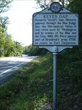 view gallery view galleryNW9.8 km |  Keyes Gap Keyes Gap
in Named Mountain Gaps Keyes Gap is a gap in the Blue Ridge Mountain on the border of Loudoun County, Virginia, and Jefferson County, West Virginia, USA. A West Virginia historical marker denotes its location along West Virginia State Route 9. posted by: Marine Biologist location: West Virginia date approved: 08/09/2008 last visited: 01/09/2022 |
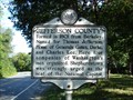
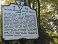 view gallery view galleryS9.8 km |  Major General Ben H. Fuller Major General Ben H. Fuller
in Virginia Historical Markers A Virginia Historical Marker placed in 2001 by the Department of Historical Resources, giving history of a Marine Corps general who lived in this area. posted by:  BruceS BruceS location: Virginia date approved: 05/09/2014 last visited: never |
 view gallery view galleryS9.8 km | Janney House - Hamilton, Virginia in Wikipedia Entries Historic house in Hamilton, Virginia posted by: BruceS location: Virginia date approved: 05/10/2014 last visited: never |
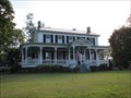 view gallery view galleryS9.8 km |  Janney House - Hamilton, Virginia Janney House - Hamilton, Virginia
in U.S. National Register of Historic Places Historic house in Hamilton, Virginia posted by: BruceS location: Virginia date approved: 05/11/2014 last visited: never |
|