 view gallery view gallery SW0.2 km SW0.2 km
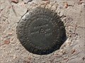
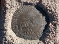
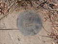
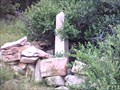
|   TT 3B (AA3438) - Douglas County, Colorado TT 3B (AA3438) - Douglas County, Colorado
in U.S. Benchmarks A USGS benchmark located at the intersection of E Cherry Creek Road and Steele Avenue. posted by:  Tom.dog Tom.dog location: Colorado date approved: 11/16/2022 last visited: never |
 view gallery view gallery NW1.6 km NW1.6 km
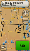
|  The "Baker" Pattern The "Baker" Pattern
in GPS Tracklog Art The Baker pattern was used by the US Navy to train pilots during WWII and is still useful today as an exercise to develop and maintain instrument proficiency. posted by: IJAdventures location: Colorado date approved: 01/08/2012 last visited: never |
 view gallery view gallery W5 km W5 km
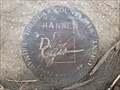
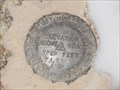
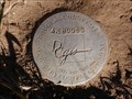
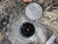
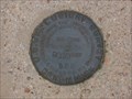
| HANNEN (AA3416) - Douglas County, Colorado in U.S. Benchmarks A Douglas County GIS Primary Control Monument in the southwest corner of the intersection of Greenland Road and Dahlberg Road. posted by: Tom.dog location: Colorado date approved: 04/08/2024 last visited: never |
 view gallery view gallerySW9 km | 4.153034 - Douglas County, Colorado in U.S. Benchmarks Douglas County GIS Secondary Control Monument on Jones Rd. posted by: Tom.dog location: Colorado date approved: 12/22/2013 last visited: never |
 view gallery view gallery E9.7 km E9.7 km
| 4 A.T.W - Elbert County, Colorado in U.S. Benchmarks USGS Benchmark northwest of Elbert, Colorado. posted by: Tom.dog location: Colorado date approved: 12/14/2013 last visited: never |
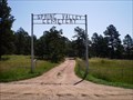 view gallery view gallerySW10 km |  Spring Valley Cemetery - Larkspur, CO Spring Valley Cemetery - Larkspur, CO
in Worldwide Cemeteries The Spring Valley Cemetery is located about 4 1/2 miles southeast of Greenland and about 10 miles southeast of Larkspur, CO in Douglas county. posted by:  condor1 condor1 location: Colorado date approved: 08/24/2009 last visited: 06/06/2014 |
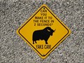 view gallery view galleryNW10 km |  Yaks Are Fast - Castle Rock, CO Yaks Are Fast - Castle Rock, CO
in Unusual Signs This sign is located at the entrance to the "Organic Yak Farm" about 2 miles west of State Hwy 83 along Lake Gulch Rd. and about 10 miles southeast of Castlerock, CO posted by: condor1 location: Colorado date approved: 08/02/2009 last visited: 04/26/2013 |
 view gallery view gallery S10.1 km S10.1 km
| 2 A.T.W - El Paso County, Colorado in U.S. Benchmarks USGS Benchmark in Northern El Paso County, Colorado. posted by: Tom.dog location: Colorado date approved: 12/11/2013 last visited: never |
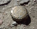
 view gallery view galleryW10.1 km | FELLHAUER (AA3412) - Douglas County, Colorado in U.S. Benchmarks Douglas County GIS Primary Control Monument located at a prominent bend in Upper Lake Gulch Road. posted by: Tom.dog location: Colorado date approved: 10/30/2022 last visited: never |
 view gallery view galleryS10.3 km | 4.180060 - Douglas County, Colorado in U.S. Benchmarks Douglas County GIS Secondary Control Monument on County Line Rd. posted by: Tom.dog location: Colorado date approved: 12/22/2013 last visited: never |
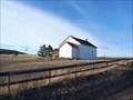
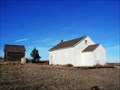 view gallery view gallerySW10.6 km |  Spring Valley School - Douglas County, Colorado Spring Valley School - Douglas County, Colorado
in U.S. National Register of Historic Places A One-Room Schoolhouse at a dirt crossroad. posted by: Big B Bob location: Colorado date approved: 12/18/2009 last visited: 07/03/2016 |
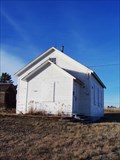 view gallery view gallerySW10.6 km |  Spring Valley School - Douglas County, Colorado Spring Valley School - Douglas County, Colorado
in Former Schools A One-Room Schoolhouse at a dirt crossroad. posted by: Big B Bob location: Colorado date approved: 12/16/2009 last visited: 07/03/2016 |
 view gallery view gallerySW10.6 km |  Spring Valley School - Douglas County, Colorado Spring Valley School - Douglas County, Colorado
in One-Room Schoolhouses A One-Room Schoolhouse at a dirt crossroad. posted by: Big B Bob location: Colorado date approved: 12/17/2009 last visited: 07/03/2016 |
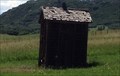 view gallery view gallerySW10.6 km |  Outhouse of Spring Valley School - Douglas County, CO Outhouse of Spring Valley School - Douglas County, CO
in Outhouses This One-Seater Outhouse sits on grounds of the old Spring Valley School Acreage. posted by: condor1 location: Colorado date approved: 07/04/2016 last visited: 07/03/2016 |
 view gallery view gallerySW10.9 km | 4.165028 - Douglas County, Colorado in U.S. Benchmarks Douglas County GIS Secondary Control Monument on Lorraine Rd. posted by: Tom.dog location: Colorado date approved: 12/22/2013 last visited: 06/06/2014 |
 view gallery view gallerySW12.2 km | S0170 (AA3113) - El Paso County, Colorado in U.S. Benchmarks Colorado Department of Highways R.O.W. marker adjacent to State Highway 83. posted by: Tom.dog location: Colorado date approved: 11/04/2022 last visited: never |
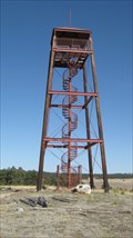 view gallery view galleryE12.2 km |  Kimsey Tower - Elbert County, CO Kimsey Tower - Elbert County, CO
in Citizen Memorials The Kimsey Tower is located on the grounds of the Peaceful Valley Scouts Ranch. posted by: condor1 location: Colorado date approved: 03/07/2011 last visited: 03/06/2011 |
 view gallery view galleryNW13.4 km |  Conrad Moschel - Douglas County, CO Conrad Moschel - Douglas County, CO
in Out of Place Graves Here Lies Conrad Moschel - This Out-of-Place marker is buried (Ha Ha), in the Colorado back country. posted by: condor1 location: Colorado date approved: 08/10/2009 last visited: 04/26/2013 |
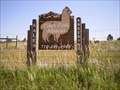 view gallery view gallerySW15 km |  Pikes Peak Alpaca's - Black Forest, CO Pikes Peak Alpaca's - Black Forest, CO
in Alpaca and Llama Farms Pikes Peak Alpacas is located about 10 miles north of Colorado Springs along State Hwy 83 and about 5 miles northwest of Black Forest. posted by: condor1 location: Colorado date approved: 08/02/2009 last visited: 08/02/2009 |
 view gallery view galleryW15 km | A 393 (KK1319) - Douglas County, Colorado in U.S. Benchmarks A metal rod on the west side of the south bound I-25 on-ramp at Exit 167. posted by: Tom.dog location: Colorado date approved: 11/04/2022 last visited: never |
 view gallery view gallerySW15 km | Pine Grove School - Colorado Springs, CO in One-Room Schoolhouses This one room schoolhouse was in service from 1912 to 1938. posted by: Johnny_Quest location: Colorado date approved: 08/04/2010 last visited: never |
 view gallery view galleryNW15.1 km | Castlewood Canyon Dam in U.S. Benchmarks Located on top of the east side of the Castlewood Canyon Dam ruins inside Colorado's Castlewood Canyon State Park. posted by: Rail Fan location: Colorado date approved: 06/18/2008 last visited: 05/03/2014 |
 view gallery view galleryW15.4 km | C 23 (KK0179) - Douglas County, Colorado in U.S. Benchmarks A benchmark disk located in the southwest corner of the E Noe Road railroad crossing in Greenland, Colorado. posted by: Tom.dog location: Colorado date approved: 11/06/2022 last visited: never |
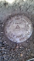 view gallery view gallerySW16.3 km | HWY 105 MILE POST 1.15 561 - El Paso County, Colorado in U.S. Benchmarks Colorado Department of Highways mile post marker off of Highway 105. posted by: Tom.dog location: Colorado date approved: 12/27/2013 last visited: never |
 view gallery view galleryS16.3 km | 1 BB (KK0282) - El Paso County, Colorado in U.S. Benchmarks A USGS benchmark in the southwest corner of the intersection of Hodgen and Bar X Roads. posted by: Tom.dog location: Colorado date approved: 11/06/2022 last visited: never |
|