 view gallery view gallery SE0 km SE0 km
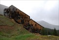
|   Champion Mill - Leadville, CO Champion Mill - Leadville, CO
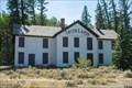
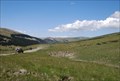
in Mills and Gins Champion Mill is part of a mining complex on the eastern slope of Mount Champion outside Leadville, Colorado. posted by:  94RedRover 94RedRover location: Colorado date approved: 12/08/2009 last visited: never |
 view gallery view gallery E0.3 km E0.3 km
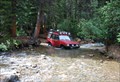
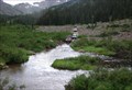
|  Halfmoon Creek Crossing - Leadville, CO Halfmoon Creek Crossing - Leadville, CO
in Bridgeless Water Crossings Halfmoon Creek Trail runs through the San Isabel National Forest, just outside of Leadville, Colorado. Be prepared, crossing the Halfmoon Creek here can be very deep depending on recent rains. posted by: 94RedRover location: Colorado date approved: 01/25/2010 last visited: never |
 view gallery view gallery NE2.6 km NE2.6 km
| Halfmoon Creek Crossing #2 - Leadville, CO in Bridgeless Water Crossings Halfmoon Creek Trail runs through the San Isabel National Forest just southwest of Leadville, Colorado. This easy stream crossing occurs near the beginning of the trail. posted by: 94RedRover location: Colorado date approved: 01/25/2010 last visited: never |
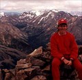
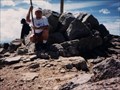
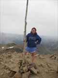 view gallery view gallerySE5.6 km |  Highest Point in Colorado (Mount Elbert) Highest Point in Colorado (Mount Elbert)
in Geographic High Points Highest of the Colorado 14ers! posted by:  Web-ling Web-ling location: Colorado date approved: 12/01/2008 last visited: 07/16/2010 |
 view gallery view gallerySE5.6 km |  Mount Elbert Mount Elbert
in Mountain Summits The highest point in Colorado! posted by: Web-ling location: Colorado date approved: 10/13/2006 last visited: 07/16/2010 |
 view gallery view gallerySE5.6 km |  Mount Elbert Mount Elbert
in Wikipedia Entries The highest point in Colorado! posted by: Web-ling location: Colorado date approved: 11/28/2009 last visited: 08/26/2010 |
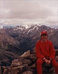
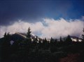 view gallery view galleryNE6.1 km | Mount Massive in Wikipedia Entries Second-highest point in Colorado! posted by: Web-ling location: Colorado date approved: 11/28/2009 last visited: never |
 view gallery view galleryNE6.1 km | Mount Massive in Mountain Summits Second-highest point in Colorado! posted by: Web-ling location: Colorado date approved: 10/14/2006 last visited: 08/03/1999 |
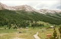
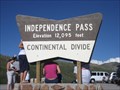 view gallery view gallery SW6.1 km SW6.1 km
|  Independence Pass, Colorado Independence Pass, Colorado
in Elevation Signs Independence Pass, one of the most frightening roads in Colorado posted by: ronjean location: Colorado date approved: 09/07/2008 last visited: 10/01/2022 |
 view gallery view galleryE7.6 km |  Mt. Massive Trailhead, Halfmoon Creek Mt. Massive Trailhead, Halfmoon Creek
in Hiking and walking trailheads This trailhead is at 10,073 feet above sea level and will take you to the top of the second highest 14er in Colorado. posted by:  DrPowercat DrPowercat location: Colorado date approved: 08/23/2009 last visited: 07/25/2009 |
 view gallery view gallery W9.2 km W9.2 km
| Independence Townsite - Aspen CO Elevation 10,830' in Elevation Signs Founded July 4, 1879 when gold was discovered, Independence was the first community in the Roaring Fork Valley. posted by: Don.Morfe location: Colorado date approved: 08/08/2020 last visited: 10/30/2021 |
 view gallery view galleryW9.2 km |  Independence Townsite - Aspen CO Independence Townsite - Aspen CO
in Ghost Towns Independence Townsite was founded July 4, 1879 when gold was discovered. It was the first community in the Roaring Fork Valley and A thriving mining camp, stagecoach and layover stop for all travel across Hunter’s Pass. posted by: Don.Morfe location: Colorado date approved: 11/30/2022 last visited: 11/17/2022 |
 view gallery view galleryW9.2 km |  FIRST - Community in the Roaring Fork Valley-Independence Townsite - Aspen CO FIRST - Community in the Roaring Fork Valley-Independence Townsite - Aspen CO
in First of its Kind Independence Townsite was founded July 4, 1879 when gold was discovered. It was the first community in the Roaring Fork Valley and A thriving mining camp, stagecoach and layover stop for all travel across Hunter’s Pass. posted by: Don.Morfe location: Colorado date approved: 11/17/2022 last visited: 11/17/2022 |
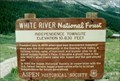 view gallery view galleryW9.2 km |  Independence Townsite-Aspen, CO Independence Townsite-Aspen, CO
in Colorado Historical Markers Elevation 10,830 feet— White River National Forest
Founded July 4, 1879 when gold was discovered, Independence was the first community in the Roaring Fork Valley. posted by: Don.Morfe location: Colorado date approved: 11/25/2019 last visited: 10/29/2021 |
 view gallery view galleryNE11.4 km |  Halfmoon Creek - Leadville, CO Halfmoon Creek - Leadville, CO
in Offroad Trails Loacted southwest of Leadville, this trail leads up to an elevation of 12,800 feet, from open plains and numerous creek crossings and ends at the hisotirc Iron Mike Mine. posted by: 94RedRover location: Colorado date approved: 09/14/2009 last visited: never |
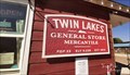 view gallery view gallerySE12.2 km | Twin Lakes General Store -Twin Lakes, CO (9,236 ft) in Elevation Signs Sign is located on side of The Twin Lakes General Store Mercantile right next to the entrance. posted by: mr.volkswagen location: Colorado date approved: 09/14/2021 last visited: never |
 view gallery view gallery N12.7 km N12.7 km
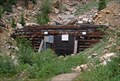
|  East Portal of the Carleton Tunnel - Leadville, CO East Portal of the Carleton Tunnel - Leadville, CO
in American Guide Series The Carlton Tunnel, once called the Busk-Ivanhoe, was built in 1893, making train passage over the Hagerman Pass from Aspen to Leadville less expensive and more secure. posted by: 94RedRover location: Colorado date approved: 08/24/2009 last visited: never |
 view gallery view galleryN12.7 km |  Carlton Tunnel - Leadville, CO Carlton Tunnel - Leadville, CO
in Abandoned Train Tunnels The Carlton Tunnel, once called the Busk-Ivanhoe, was built in 1893, making train passage over the Hagerman Pass from Aspen to Leadville less expensive and more secure. posted by: 94RedRover location: Colorado date approved: 08/24/2009 last visited: never |
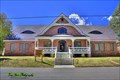 view gallery view galleryNE13.7 km |  Leadville National Fish Hatchery - Leadville, CO Leadville National Fish Hatchery - Leadville, CO
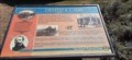
in U.S. National Register of Historic Places There are also information panels around the hatchery with more info. Also there are some exhibits in the main building. posted by: mr.volkswagen location: Colorado date approved: 10/17/2015 last visited: 10/13/2015 |
 view gallery view galleryNE13.8 km |  Leadville National Fish Hatchery - Leadville, CO Leadville National Fish Hatchery - Leadville, CO
in Fish Hatcheries There are also information panels around the hatchery with more info. Also there are some exhibits in the main building. posted by: mr.volkswagen location: Colorado date approved: 10/16/2015 last visited: 08/31/2017 |
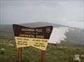 view gallery view galleryN14.2 km | Hagerman Pass - 11,925 feet - Leadville, CO in Elevation Signs Just west of Leadville, Colorado, Hagerman Pass follows the old Colorado Midland Railroad towards Aspen, reaching at its peak 11,925 feet. posted by: 94RedRover location: Colorado date approved: 08/09/2009 last visited: never |
 view gallery view gallerySE15 km | Interlaken Resort District - Twin Lakes CO in U.S. National Register of Historic Places Interlaken Resort District is located on the the south side of Twin Lakes. posted by: mr.volkswagen location: Colorado date approved: 09/14/2021 last visited: never |
 view gallery view gallerySE15.1 km | Dexter's Cabin - Twin Lakes, CO in Colorado Historical Markers Dexter's Cabin is located on the Interlaken Trail on the south side of Twin Lakes in near Twin Lakes, CO in Lake County. posted by: mr.volkswagen location: Colorado date approved: 09/14/2021 last visited: never |
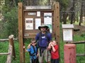
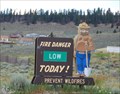 view gallery view galleryNE15.9 km |  Crystal Lakes Work Center Smokey - Leadville, CO Crystal Lakes Work Center Smokey - Leadville, CO
in Smokey Bear Sign Sightings Along Highway 24, just south of Leadville, Colorado, this Smokey stands guard at the entrance tot he Crystal Lakes Work Center. posted by: 94RedRover location: Colorado date approved: 08/10/2009 last visited: never |
 view gallery view galleryE16.3 km | Weston Pass - Leadville, CO in Offroad Trails Weston Pass, which once carried mining supplies and travelers over the Weston Peak from Fairplay and Leadville, crosses at 11,921 feet. posted by: 94RedRover location: Colorado date approved: 08/17/2009 last visited: 09/19/2015 |
|