 view gallery view gallery SE7.2 km SE7.2 km
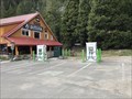
|   Strawberry Station General Store Chargers - Strawberry, CA Strawberry Station General Store Chargers - Strawberry, CA
in Electric Car Charging Stations A charger in front of the Strawberry Station General store in Strawberry, CA. posted by:  saopaulo1 saopaulo1 location: California date approved: 08/31/2018 last visited: never |
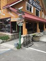 view gallery view gallerySE7.2 km |  Strawberry Station General Store Directional Arrows - Strawberry, CA Strawberry Station General Store Directional Arrows - Strawberry, CA
in Direction and Distance Arrows Directional arrows in front of the Strawberry Station Store. posted by: saopaulo1 location: California date approved: 09/17/2018 last visited: never |
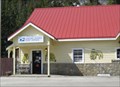
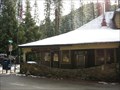
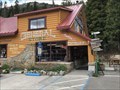 view gallery view gallerySE7.2 km |  Strawberry Station General Store - Strawberry, CA Strawberry Station General Store - Strawberry, CA
in The Local Neighborhood Grocer Strawberry Station General Store is located in Strawberry, CA. posted by: saopaulo1 location: California date approved: 09/09/2018 last visited: never |
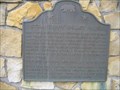 view gallery view gallerySE7.2 km |  Strawberry Valley House Strawberry Valley House
in Pony Express Monuments California Registered Historical Landmark #707 posted by:  heringermr heringermr location: California date approved: 05/12/2007 last visited: 09/23/2009 |
 view gallery view gallerySE7.2 km |  Strawberry Valley House Strawberry Valley House
in California Historical Markers California Registered Historical Landmark #707 posted by: heringermr location: California date approved: 05/15/2007 last visited: never |
 view gallery view gallerySE7.2 km |  Twin Bridges, CA - 95735 Twin Bridges, CA - 95735
in U.S. Post Offices The post office for Twin Bridges in next to the Strawberry Market and Deli on Hway 50. posted by: saopaulo1 location: California date approved: 03/31/2010 last visited: 11/27/2011 |
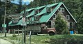 view gallery view gallerySE7.2 km |  Strawberry Lodge - Strawberry, CA Strawberry Lodge - Strawberry, CA
in Lodge-Style Accommodations The Strawberry Lodge in Strawberry, CA. posted by: saopaulo1 location: California date approved: 08/31/2018 last visited: never |
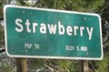 view gallery view gallerySE7.2 km |  Strawberry, CA - 5,800 Ft Strawberry, CA - 5,800 Ft
in Elevation Signs An elevation sign for the community of Strawberry, CA. posted by: saopaulo1 location: California date approved: 01/14/2011 last visited: never |
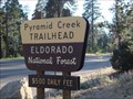
 view gallery view gallerySE7.6 km |  Horsetail Falls - El Dorado Co. CA Horsetail Falls - El Dorado Co. CA
in Hiking and walking trailheads Horsetail Falls, aka Pyramid Creek Trail, is a day hike with elevation gain from 6,120 feet to 6,880 feet. Right, about 1/2 mile vertical climb on granite, boulders, and trail in the manzanita. posted by: sbcamper location: California date approved: 10/01/2014 last visited: 10/09/2014 |
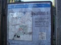
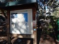
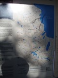
 view gallery view gallerySE7.6 km |  You Are Here - Pyramid Creek Trail - El Dorado Co CA You Are Here - Pyramid Creek Trail - El Dorado Co CA
in 'You Are Here' Maps Beginning of a 1.5 mile vertical climb to view the waterfall of Pyramid Creek. posted by: sbcamper location: California date approved: 09/28/2014 last visited: never |
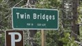
 view gallery view gallerySE7.7 km | Twin Bridges, CA - 6117 Ft in Elevation Signs A sign on Hway 50 as you enter Twin Bridges, CA. posted by: saopaulo1 location: California date approved: 06/06/2011 last visited: never |
 view gallery view gallerySE7.7 km |  Twin Bridges, CA - Pop: 10 Twin Bridges, CA - Pop: 10
in Population Signs A sign on Hway 50 as you enter Twin Bridges, CA. posted by: saopaulo1 location: California date approved: 06/06/2011 last visited: never |
 view gallery view gallery SW8.2 km SW8.2 km
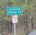
| Hway 50 - 5,000 Ft - Kyburz, CA in Elevation Signs An elevation marker on Hway 50 by Kyburz, CA. posted by: saopaulo1 location: California date approved: 06/07/2011 last visited: never |
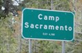 view gallery view gallerySE8.5 km | Camp Sacramento, CA - 6500 Ft in Elevation Signs A sign at the entrance of Camp Sacramento, CA. The community is located in El Dorado County on Hway 50. posted by: saopaulo1 location: California date approved: 06/06/2011 last visited: never |
 view gallery view gallery E11.4 km E11.4 km
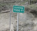
| Hway 50 - 7,000 Ft - Philips, CA in Elevation Signs An elevation sign by Philips, CA on Hway 50. posted by: saopaulo1 location: California date approved: 06/07/2011 last visited: never |
 view gallery view gallerySW11.7 km | Kyburz, CA - Pop: 139 in Population Signs A population sign in Kyburz, CA. posted by: saopaulo1 location: California date approved: 06/06/2011 last visited: 01/05/1988 |
 view gallery view gallerySW11.7 km | Kyburz, CA - 95720 in U.S. Post Offices A post office on Hway 50 in Kyburz, CA. posted by: saopaulo1 location: California date approved: 01/10/2011 last visited: 11/22/2011 |
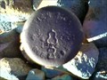 view gallery view gallery W12.4 km W12.4 km
|  RCE1984 RCE1984
in U.S. Benchmarks Top of small rise on the edge of the forest service land in El Dorado County posted by: bd_gun_dlr location: California date approved: 10/09/2007 last visited: never |
 view gallery view gallerySW13.2 km | Webster's Sugar Loaf House in California Historical Markers Pony Express Remount Station posted by: heringermr location: California date approved: 05/15/2007 last visited: never |
 view gallery view gallerySW13.2 km | Webster's Sugar Loaf House in Pony Express Monuments California Registered Historical Landmark #706 posted by: heringermr location: California date approved: 05/11/2007 last visited: 09/23/2009 |
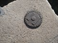 view gallery view galleryE13.4 km | PGE Survey Mark - El Dorado Co. CA in U.S. Benchmarks Found this one at the outlet for El Dorado Irrigation District
lake/reservoir. posted by: sbcamper location: California date approved: 09/27/2014 last visited: never |
 view gallery view galleryE13.4 km |  Tahoe Rim Trail - El Dorado Co/Placer Co. CA & Washoe Co,Carson City/Douglas Co. NV Tahoe Rim Trail - El Dorado Co/Placer Co. CA & Washoe Co,Carson City/Douglas Co. NV
in Long Distance Hiking Trails This is one start or end point for a loop hike around Lake Tahoe.
It is 165 miles or 266 kilometers. Some folks do in and back portions.
This trail extends into the Desolation Wilderness Area and would require use permits (which are limited by posted by: sbcamper location: California date approved: 09/27/2014 last visited: 09/29/2014 |
 view gallery view galleryE13.4 km | Pacific Crest Trail at Echo Lake - El Dorado Co. CA in Long Distance Hiking Trails This is where the Pacific Crest Trail parallels the Tahoe Rim Trail on the west side of Lake Tahoe. The entire trail goes from the Canadian border to the Mexican border. posted by: sbcamper location: California date approved: 09/27/2014 last visited: 09/05/2014 |
 view gallery view galleryE13.4 km |  El Dorado National Forest - CA El Dorado National Forest - CA
in Public Access Lands This National Forest encompasses parts of Amador, El Dorado, and Placer counties. It welcomes over 2 million visitors annually, all seasons. Generally it is between HW88 and HW 50. posted by: sbcamper location: California date approved: 06/24/2016 last visited: never |
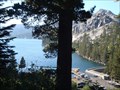 view gallery view galleryE13.4 km |  Echo Lake - El Dorado County CA Echo Lake - El Dorado County CA
in Natural Lakes Echo Lakes are a pair of volcanic lakes. Upper and Lower. Maybe a slide separated them. posted by: sbcamper location: California date approved: 09/28/2014 last visited: 10/09/2014 |
|