 view gallery view gallery NW1.8 km NW1.8 km
|   South Lake Tahoe, CA - 96150 (Meyers Station) South Lake Tahoe, CA - 96150 (Meyers Station)
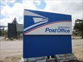
in U.S. Post Offices A post office in Meyers, CA. Meyers is located close to South Lake Tahoe. posted by:  saopaulo1 saopaulo1 location: California date approved: 05/17/2011 last visited: 10/07/2013 |
 view gallery view galleryNW1.8 km |  1 Alpine Meadows Weddings - South Lake Tahoe, CA 1 Alpine Meadows Weddings - South Lake Tahoe, CA
in Wedding Chapels A wedding chapel in South Lake Tahoe. posted by: saopaulo1 location: California date approved: 01/13/2011 last visited: never |
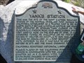 view gallery view galleryNW1.9 km |  Yank's Station Yank's Station
in Pony Express Monuments California Registered Historical Landmark #708 posted by:  heringermr heringermr location: California date approved: 05/17/2007 last visited: 06/10/2015 |
 view gallery view galleryNW1.9 km |  Yank's Station Yank's Station
in California Historical Markers California Registered Historical Landmark #708 posted by: heringermr location: California date approved: 05/23/2007 last visited: 10/13/2014 |
 view gallery view galleryNW1.9 km |  Smokey Bear - South Lake Tahoe, CA Smokey Bear - South Lake Tahoe, CA
in Smokey Bear Sign Sightings A Smokey Bear as you enter the city of South Lake Tahoe. posted by: saopaulo1 location: California date approved: 08/30/2018 last visited: never |
 view gallery view galleryNW2.1 km |  Little Free Library #9089 - South Lake Tahoe, CA Little Free Library #9089 - South Lake Tahoe, CA
in Free Community Book Exchanges A Little Free Library at 1069 Magua Street #4 in South Lake Tahoe, CA. posted by: mojoloco7 location: California date approved: 10/28/2014 last visited: 09/02/2014 |
 view gallery view gallery SW3.1 km SW3.1 km
|  Oldest Volcano woodstove in CA - El Dorado Co. CA Oldest Volcano woodstove in CA - El Dorado Co. CA
in Superlatives Manufactured in Jacksonville Florida. Hope they waited until a train could bring it to Nevada. When there was no electricity, this was the primary source to heat a room, cook meals, hot water always ready. posted by: sbcamper location: California date approved: 10/07/2014 last visited: never |
 view gallery view gallerySW3.1 km |  Alpine Club / Lincoln Highway - El Dorado Co. CA Alpine Club / Lincoln Highway - El Dorado Co. CA
in Lincoln Highway Part of the old, old highway. At the top of Echo Summit where HW50 now passes. posted by: sbcamper location: California date approved: 10/02/2014 last visited: 10/06/2014 |
 view gallery view gallery N3.4 km N3.4 km
|  Lake Tahoe Golf Course - South Lake Tahoe, CA Lake Tahoe Golf Course - South Lake Tahoe, CA
in Public and Private Golf Courses A public golf course on state land. posted by: saopaulo1 location: California date approved: 08/28/2018 last visited: never |
 view gallery view gallerySW3.4 km |  Echo Lake Sno Park - El Dorado Co. CA Echo Lake Sno Park - El Dorado Co. CA
in Winter Sports Locations Good parking for snowshoeing, cross country skiing, snowmobiling.
And most important, just building a snowman or finding a potty. posted by: sbcamper location: California date approved: 09/30/2014 last visited: never |
 view gallery view gallery W3.7 km W3.7 km
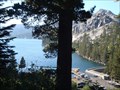
|  Echo Lake - El Dorado County CA Echo Lake - El Dorado County CA
in Natural Lakes Echo Lakes are a pair of volcanic lakes. Upper and Lower. Maybe a slide separated them. posted by: sbcamper location: California date approved: 09/28/2014 last visited: 10/09/2014 |
 view gallery view galleryW3.7 km |  Echo Lake boat ramp - El Dorado Co CA Echo Lake boat ramp - El Dorado Co CA
in Boat Ramps Small craft put in for $20. and kayaks and canoes for $5. each. posted by: sbcamper location: California date approved: 09/27/2014 last visited: 09/27/2014 |
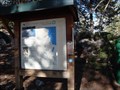
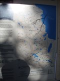
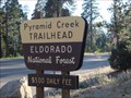 view gallery view galleryW3.7 km |  El Dorado National Forest - CA El Dorado National Forest - CA
in Public Access Lands This National Forest encompasses parts of Amador, El Dorado, and Placer counties. It welcomes over 2 million visitors annually, all seasons. Generally it is between HW88 and HW 50. posted by: sbcamper location: California date approved: 06/24/2016 last visited: never |
 view gallery view galleryW3.7 km |  Tahoe Rim Trail - El Dorado Co/Placer Co. CA & Washoe Co,Carson City/Douglas Co. NV Tahoe Rim Trail - El Dorado Co/Placer Co. CA & Washoe Co,Carson City/Douglas Co. NV
in Long Distance Hiking Trails This is one start or end point for a loop hike around Lake Tahoe.
It is 165 miles or 266 kilometers. Some folks do in and back portions.
This trail extends into the Desolation Wilderness Area and would require use permits (which are limited by posted by: sbcamper location: California date approved: 09/27/2014 last visited: 09/29/2014 |
 view gallery view galleryW3.7 km | Pacific Crest Trail at Echo Lake - El Dorado Co. CA in Long Distance Hiking Trails This is where the Pacific Crest Trail parallels the Tahoe Rim Trail on the west side of Lake Tahoe. The entire trail goes from the Canadian border to the Mexican border. posted by: sbcamper location: California date approved: 09/27/2014 last visited: 09/05/2014 |
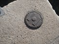 view gallery view galleryW3.7 km |  PGE Survey Mark - El Dorado Co. CA PGE Survey Mark - El Dorado Co. CA
in U.S. Benchmarks Found this one at the outlet for El Dorado Irrigation District
lake/reservoir. posted by: sbcamper location: California date approved: 09/27/2014 last visited: never |
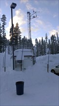 view gallery view gallerySW4.3 km |  Nebelhorn Weather Station Nebelhorn Weather Station
in Weather Stations This weather station is located at Nebelhorn, AKA the Adventure Mountain Snow Park. posted by: California Bear location: California date approved: 01/04/2013 last visited: never |
 view gallery view galleryN5.6 km |  Rick Jenkins - South Lake Tahoe, CA Rick Jenkins - South Lake Tahoe, CA
in Citizen Memorials A plaque in front of the South Lake Tahoe Airport. posted by: saopaulo1 location: California date approved: 05/13/2010 last visited: 05/14/2010 |
 view gallery view galleryN5.6 km |  South Lake Tahoe Airport/City Hall Safe Haven - South Lake Tahoe, CA South Lake Tahoe Airport/City Hall Safe Haven - South Lake Tahoe, CA
in Safe Place Havens A Safe Haven at the South Lake City airport and city hall facility, The building houses the airport and the city offices. posted by: saopaulo1 location: California date approved: 03/31/2010 last visited: 09/13/2010 |
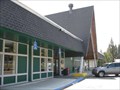
 view gallery view galleryN5.6 km |  South Lake Tahoe, CA South Lake Tahoe, CA
in City and Town Halls The South Lake Tahoe city hall is in the same building at the city's airport. posted by: saopaulo1 location: California date approved: 04/01/2010 last visited: 09/05/2014 |
 view gallery view galleryN5.8 km |  Lake Tahoe Airport - South Lake Tahoe, CA Lake Tahoe Airport - South Lake Tahoe, CA
in Airports This airport serves private and corporate travelers. posted by: Free2bme29 location: California date approved: 07/13/2009 last visited: 09/05/2014 |
 view gallery view galleryN5.8 km |  South Lake Tahoe, CA - 6252 South Lake Tahoe, CA - 6252
in Elevation Signs A sign on Hway 50 in South Lake Tahoe, CA. posted by: saopaulo1 location: California date approved: 08/31/2018 last visited: never |
 view gallery view galleryN5.8 km |  South Lake Tahoe, CA - Pop: 23609 South Lake Tahoe, CA - Pop: 23609
in Population Signs A sign on Hway 50 in South Lake Tahoe, CA. posted by: saopaulo1 location: California date approved: 09/09/2018 last visited: never |
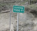 view gallery view galleryW6.3 km | Hway 50 - 7,000 Ft - Philips, CA in Elevation Signs An elevation sign by Philips, CA on Hway 50. posted by: saopaulo1 location: California date approved: 06/07/2011 last visited: never |
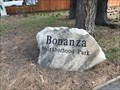 view gallery view galleryN7.2 km |  Bonanza Neighborhood Park - South Lake Tahoe, CA Bonanza Neighborhood Park - South Lake Tahoe, CA
in Municipal Parks and Plazas A small park in South Lake Tahoe. posted by: saopaulo1 location: California date approved: 08/28/2018 last visited: never |
|