 view gallery view gallery SW1.1 km SW1.1 km
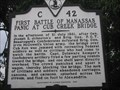
|   First Battle of Manassas (Panic at Cub Creek Bridge) First Battle of Manassas (Panic at Cub Creek Bridge)
in Virginia Historical Markers This marker describes the Panic at Cub Creek, a part of the First Battle of Manassas. It still amazes me that the wealthy elite of Washington believed this was going to be an easy Union victory, and thought it would be a great time and place to picnic. posted by:  pixieslayer pixieslayer location: Virginia date approved: 08/02/2006 last visited: 09/27/2014 |
 view gallery view gallery E1.3 km E1.3 km
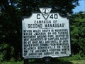
| Campaign of Second Manassas in Virginia Historical Markers Virginia Historical Highway Marker C-40. posted by:  garmin_geek garmin_geek location: Virginia date approved: 07/26/2010 last visited: 05/01/2014 |
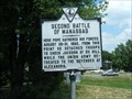 view gallery view galleryE1.3 km | Second Battle of Manassas in Virginia Historical Markers Virginia Historical Highway Marker C-22 posted by: garmin_geek location: Virginia date approved: 07/26/2010 last visited: 05/01/2014 |
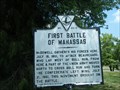 view gallery view galleryE1.3 km | First Battle of Manassas in Virginia Historical Markers Virginia Historical Highway Marker C-20 posted by: garmin_geek location: Virginia date approved: 07/26/2010 last visited: 05/10/2014 |
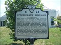 view gallery view galleryE1.3 km | Confederate Defenses in Virginia Historical Markers Virginia Historical Highway Marker C-21. posted by: garmin_geek location: Virginia date approved: 07/26/2010 last visited: 09/24/2010 |
 view gallery view gallery SE2.3 km SE2.3 km
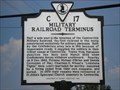
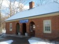
| Military Railroad Terminus in Virginia Historical Markers Military Railroad Terminus in Centreville, VA posted by: theroths3 location: Virginia date approved: 07/24/2006 last visited: 05/01/2014 |
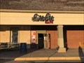 view gallery view galleryE2.6 km |  Lulu Cafe - Centerville, Virginia Lulu Cafe - Centerville, Virginia
in Karaoke Bars Located within the "Old Centerville Crossing" shopping center. posted by: flyingmoose location: Virginia date approved: 03/08/2021 last visited: never |
 view gallery view gallery NE2.7 km NE2.7 km
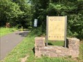
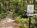
|  Big Rocky Run Trail "West" - Fairfax, Virginia Big Rocky Run Trail "West" - Fairfax, Virginia
in Hiking and walking trailheads Trailhead is within the Ellanor C Lawrence Park next to Cabell's Mill. posted by: flyingmoose location: Virginia date approved: 06/07/2021 last visited: never |
 view gallery view galleryNE3.9 km | Ellanor C Lawrence EC4 - Fairfax, Virginia in Hiking and walking trailheads Located at the intersection of Walney and Poplar Tree Roads. posted by: flyingmoose location: Virginia date approved: 06/07/2021 last visited: never |
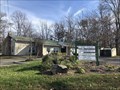
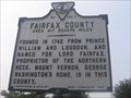 view gallery view gallerySW4 km | Fairfax County - Prince William County in Virginia Historical Markers This marker gives a very brief history of Fairfax County and Prince William County. posted by: pixieslayer location: Virginia date approved: 08/02/2006 last visited: 06/01/2001 |
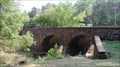
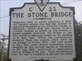 view gallery view gallerySW4 km | The Stone Bridge in Virginia Historical Markers This marker was added in 2000, and stands beside the Fairfax County/Prince William County marker. It describes the stone bridge over Bull Run, an important landmark during the Civil War. posted by: pixieslayer location: Virginia date approved: 08/02/2006 last visited: 06/01/2001 |
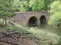 view gallery view gallerySW4.7 km |  Stone Bridge - Manassas, VA Stone Bridge - Manassas, VA
in American Guide Series The stone bridge across Bull Run was an important location during both the First and Second Battles of Manassas during the U.S. Civil War. posted by: Rayman location: Virginia date approved: 10/14/2009 last visited: 03/01/2020 |
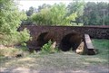
 view gallery view gallerySW4.7 km |  Stone Bridge across Bull Run - Manassas, VA Stone Bridge across Bull Run - Manassas, VA
in Wikipedia Entries The Stone Bridge is a bridge that crosses Bull Run river in the Manassas National Battlefield Park in Manassas, Virginia.
posted by: Lat34North location: Virginia date approved: 09/16/2007 last visited: 12/18/2017 |
 view gallery view gallerySW4.7 km |  Stone Bridge across Bull Run - Manassas, VA Stone Bridge across Bull Run - Manassas, VA
in NRHP Historic Districts - Contributing Buildings The Stone Bridge is a bridge that crosses Bull Run river in the Manassas National Battlefield Park in Manassas, Virginia. posted by: Lat34North location: Virginia date approved: 07/01/2011 last visited: 12/18/2017 |
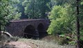 view gallery view gallerySW4.7 km |  Stone Bridge across Bull Run - Manassas, VA Stone Bridge across Bull Run - Manassas, VA
in Stone Bridges The Stone Bridge is a bridge that crosses Bull Run river in the Manassas National Battlefield Park in Manassas, Virginia. posted by: Lat34North location: Virginia date approved: 09/21/2007 last visited: 03/01/2020 |
 view gallery view gallerySW5 km |  Manassas Safety Rest Area/Welcome Center - I-66 WB - Manassas, VA Manassas Safety Rest Area/Welcome Center - I-66 WB - Manassas, VA
in Highway Rest Areas The Manassas Safety Rest Area/Welcome Center is located on Interstate 66 West at mile marker 48 in Manassas, Prince William County, Virginia posted by: outdoorboy34 location: Virginia date approved: 01/26/2017 last visited: never |
 view gallery view gallerySW5 km | Manassas Safety Rest Area East - I-66 EB - Manassas, VA in Highway Rest Areas The Manassas Safety Rest Area East is located on Interstate 66 East at mile marker 48 in Manassas, Prince William County, Virginia posted by: outdoorboy34 location: Virginia date approved: 01/26/2017 last visited: never |
 view gallery view galleryNE5 km |  New Hope Fellowship Church - Chantilly, Virginia New Hope Fellowship Church - Chantilly, Virginia
in Wesleyan Churches Located along the Northbound side of Stringfellow Road and next to Greenbriar Park. posted by: flyingmoose location: Virginia date approved: 11/25/2020 last visited: never |
 view gallery view gallery S5.3 km S5.3 km
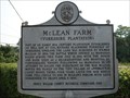
| McLean Farm (Yorkshire Plantation) in Virginia Historical Markers The McLean's witnessed the beginning of the Civil War at their home here in Yorkshire, and the end at their home in Appomattox Court House. McLean is supposed to have said "The war began in my dining room and ended in my parlor". Related to WMK8X. posted by: theroths3 location: Virginia date approved: 08/29/2006 last visited: 08/25/2006 |
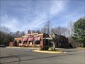 view gallery view galleryE6 km |  Applebees - Fairfax, Virginia Applebees - Fairfax, Virginia
in Applebee's Restaurants Located in the North East corner of the Fair Lakes Shopping Center. posted by: flyingmoose location: Virginia date approved: 11/20/2020 last visited: never |
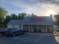 view gallery view galleryNE6.1 km |  The Burger Shack - Chantilly, Virginia The Burger Shack - Chantilly, Virginia
in Best Burgers in Town Located along the eastbound side of Route 50 in a historic building. posted by: flyingmoose location: Virginia date approved: 06/29/2021 last visited: never |
 view gallery view galleryNE6.1 km |  Finn Family Moomintroll - Fairfax, Virginia Finn Family Moomintroll - Fairfax, Virginia
in Moomins Located in the young adult book section of the Chantilly Regional Library. posted by: flyingmoose location: Virginia date approved: 05/11/2021 last visited: never |
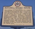 view gallery view galleryNE6.1 km | Mitchell-Weeks House in Virginia Historical Markers I've driven past this literally hundreds of times and never noticed this sign or the house. It's just off the eastbound service road on US 50. posted by: pixieslayer location: Virginia date approved: 08/05/2006 last visited: 02/19/2011 |
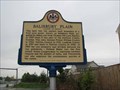 view gallery view galleryNE6.3 km | Salisbury Plain in Virginia Historical Markers Another historic marker along Route 50 posted by: robert location: Virginia date approved: 06/05/2007 last visited: 02/19/2011 |
 view gallery view gallery W6.3 km W6.3 km
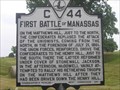
| First Battle of Manassas in Virginia Historical Markers This is one of 4 historical markers on a gravel pull off of 29 eastbound. Placed in 1931, it was the first marker on this pull off and describes the First Battle of Manassas. posted by: pixieslayer location: Virginia date approved: 08/03/2006 last visited: 08/02/2023 |
|