 view gallery view gallery S6.9 km S6.9 km
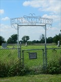
|   Black Jack Cemetery - Rural Douglas County, Ks. Black Jack Cemetery - Rural Douglas County, Ks.
in Worldwide Cemeteries This small cemetery is located on E2080 Road in Rural Douglas County just east of Baldwin City. posted by:  iconions iconions location: Kansas date approved: 08/20/2013 last visited: 08/18/2013 |
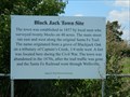 view gallery view galleryS6.9 km |  Black Jack Town Site - Rural Douglas County, Ks. Black Jack Town Site - Rural Douglas County, Ks.
in Kansas Historical Markers This wooden sign is located at the southeast corner of the Black Jack Cemetery in Rural Douglas County, Ks. posted by: iconions location: Kansas date approved: 08/22/2013 last visited: 04/05/2014 |
 view gallery view gallery SW7.2 km SW7.2 km
|  Santa Fe Trail in Douglas County, KS, USA Santa Fe Trail in Douglas County, KS, USA
in Daughters of the American Revolution Towns along the Santa Fe Trail in Douglas County, back then were: Baldwin City, Worden, Globe posted by: YoSam. location: Kansas date approved: 09/16/2023 last visited: never |
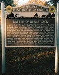 view gallery view gallerySW7.2 km | Battle of Black Jack - US - 56 - Baldwin, KS in Kansas Historical Markers Battle of Black Jack posted by: iconions location: Kansas date approved: 12/30/2007 last visited: 04/27/2006 |
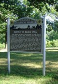 view gallery view gallerySW7.2 km |  Battle of Blackjack - Baldwin City, KS Battle of Blackjack - Baldwin City, KS
in Civil Rights Memorials Battle of Black Jack First Battle Between Free and Slave States fought on these Grounds June 2, 1856. posted by: YoSam. location: Kansas date approved: 04/16/2024 last visited: never |
 view gallery view gallerySW7.2 km |  Amelia J. Betts - Black Jack Park - Baldwin, KS Amelia J. Betts - Black Jack Park - Baldwin, KS
in Citizen Memorials Historic marker erected in her honor. posted by: YoSam. location: Kansas date approved: 01/17/2023 last visited: never |
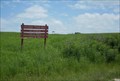
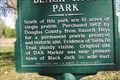 view gallery view gallerySW7.2 km | Black Jack Park - Baldwin City, KS in Kansas Historical Markers Roadside park, which now opens up to the battle site. posted by: YoSam. location: Kansas date approved: 03/22/2015 last visited: 04/05/2014 |
 view gallery view gallerySW7.2 km | Santa Fe Trail - Baldwin City, KS in Kansas Historical Markers Roadside park with entrance to Black Jack Battlefield and exposure to the trail ruts posted by: YoSam. location: Kansas date approved: 03/22/2015 last visited: 04/05/2014 |
 view gallery view gallerySW7.2 km |  Santa Fe Trail in Douglas County, KS Santa Fe Trail in Douglas County, KS
in Wagon Roads and Trails Towns along the Santa Fe Trail in Douglas County, back then were: Baldwin City, Worden, Globe posted by: YoSam. location: Kansas date approved: 03/22/2015 last visited: never |
 view gallery view gallerySW7.2 km |  Santa Fe Trail--Douglas County Trail Segments - Baldwin City, Kansas Santa Fe Trail--Douglas County Trail Segments - Baldwin City, Kansas
in U.S. National Register of Historic Places These very well preserved trail ruts are located east of E 2000th Road and 1/10 of a mile south of the Junction of US-56 near Baldwin City, Kansas. posted by: iconions location: Kansas date approved: 06/18/2009 last visited: 04/27/2006 |
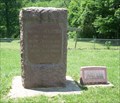
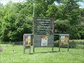
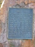
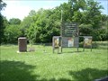 view gallery view gallerySW7.6 km | Black Jack Battlefield - Baldwin City, Kansas in U.S. National Register of Historic Places These markers commemorate the Battle of Black Jack fought between Freestate and Proslavery forces on June 2, 1855. It is located at the junction of E 2000th Road and N 175th Road in the Robert Hall Pearson Park, near Baldwin City, Kansas. posted by: iconions location: Kansas date approved: 06/18/2009 last visited: 04/25/2013 |
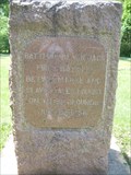
 view gallery view gallerySW7.6 km |  First Battle Between Free and Slave States - Baldwin City, Ks First Battle Between Free and Slave States - Baldwin City, Ks
in First of its Kind These markers commemorate the Battle of Black Jack fought between Freestate and Proslavery forces on June 2, 1855. It is located at the junction of E 2000th Road and N 175th Road in the Robert Hall Pearson Park. posted by: iconions location: Kansas date approved: 06/16/2009 last visited: 04/25/2013 |
 view gallery view gallerySW7.6 km |  Battle of Black Jack - Baldwin City, Ks Battle of Black Jack - Baldwin City, Ks
in U.S. Civil War Sites These markers commemorate the Battle of Black Jack fought between Freestate and Proslavery forces on June 2, 1855. It is located at the junction of E 2000th Road and N 175th Road in the Robert Hall Pearson Park. posted by: iconions location: Kansas date approved: 06/16/2009 last visited: 04/25/2013 |
 view gallery view gallerySW7.6 km |  Battle of Black Jack - Baldwin City, Kansas Battle of Black Jack - Baldwin City, Kansas
in Wikipedia Entries These markers commemorate the Battle of Black Jack fought between Freestate and Proslavery forces on June 2, 1855. It is located at the junction of E 2000th Road and N 175th Road in the Robert Hall Pearson Park. posted by: iconions location: Kansas date approved: 08/07/2017 last visited: never |
 view gallery view gallerySW7.6 km |  Battle of Black Jack - Baldwin City, Ks Battle of Black Jack - Baldwin City, Ks
in Battlefields This Battle between Free-State and Pro-Slavery forces took place on June 2, 1856 during the "Bleeding Kansas" era. posted by: iconions location: Kansas date approved: 06/19/2009 last visited: 04/25/2013 |
 view gallery view gallery W7.6 km W7.6 km
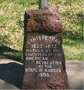
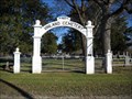
|  Vinland Cemetery Arch - 1922 - Vinland, Kansas Vinland Cemetery Arch - 1922 - Vinland, Kansas
in Dated Architectural Structures Multifarious This whitewashed, stone entry arch is located at the entry of the Vinland Cemetery - located on East 1750 Road between North 700 and 800 Roads. posted by: iconions location: Kansas date approved: 09/18/2021 last visited: never |
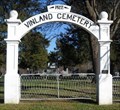 view gallery view galleryW7.6 km |  Vinland Cemetery Arch - Vinland, Kansas Vinland Cemetery Arch - Vinland, Kansas
in Freestanding Arches This whitewashed, stone entry arch is located at the entry of the Vinland Cemetery - located on East 1750 Road between North 700 and 800 Roads. posted by: iconions location: Kansas date approved: 09/18/2021 last visited: never |
 view gallery view galleryW7.6 km | Vinland Cemetery - Vinland, Ks. in Worldwide Cemeteries The Vinland Cemetery is located on East 1750 Road between North 700 and 800 Roads. posted by: iconions location: Kansas date approved: 11/05/2009 last visited: 01/31/2010 |
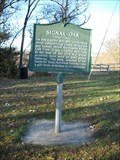
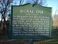 view gallery view galleryW7.7 km | Signal Oak (metal) - rural Douglas County, Kansas in Kansas Historical Markers This metal marker is located in a small park overlooking the Kaw and Wakarusa Valleys. It is north of Baldwin City along East 1750 Road. posted by: iconions location: Kansas date approved: 09/20/2021 last visited: never |
 view gallery view galleryW7.7 km |  The Signal Oak - Baldwin City, Kansas The Signal Oak - Baldwin City, Kansas
in News Article Locations This small park overlooking the Kaw and Wakarusa Valleys is north of Baldwin City along East 1750 Road. posted by: iconions location: Kansas date approved: 09/24/2021 last visited: never |
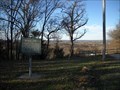 view gallery view galleryW7.7 km |  Signal Oak Park - rural Douglas County, Kansas Signal Oak Park - rural Douglas County, Kansas
in Municipal Parks and Plazas This small park overlooking the Kaw and Wakarusa Valleys is north of Baldwin City along East 1750 Road. posted by: iconions location: Kansas date approved: 09/20/2021 last visited: never |
 view gallery view galleryW7.7 km | Signal Oak - rural Douglas County, Kansas in American Civil War Monuments and Memorials This metal marker is located in a small park overlooking the Kaw and Wakarusa Valleys. It is north of Baldwin City along East 1750 Road. posted by: iconions location: Kansas date approved: 09/21/2021 last visited: never |
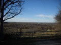 view gallery view galleryW7.7 km |  Signal Oak Park - rural Douglas County, Kansas Signal Oak Park - rural Douglas County, Kansas
in Scenic Roadside Look-Outs This small park overlooking the Kaw and Wakarusa Valleys is north of Baldwin City along East 1750 Road. posted by: iconions location: Kansas date approved: 09/21/2021 last visited: never |
 view gallery view galleryW7.7 km | Signal Oak (stone plinth) - rural Douglas County, Kansas in Kansas Historical Markers This metal marker on a granite boulder is located in a small park overlooking the Kaw and Wakarusa Valleys. It is north of Baldwin City along East 1750 Road. posted by: iconions location: Kansas date approved: 09/20/2021 last visited: never |
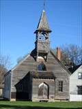 view gallery view galleryW7.9 km |  (former) Vinland Presbyterian Church - Vinland, Kansas (former) Vinland Presbyterian Church - Vinland, Kansas
in Presbyterian Churches This one-story, wood frame, Gothic Revival former church is located at 697 East 1725 Road in Vinland, Kansas. posted by: iconions location: Kansas date approved: 09/19/2021 last visited: never |
|