 view gallery view gallery SE3.4 km SE3.4 km
|   Lower Marlboro Calvert County - Lower Marlboro, MD Lower Marlboro Calvert County - Lower Marlboro, MD
in Signs of History Before the American Revolution, Lower Marlborough (the spelling officially changed to Marlboro in the 19th century) was a thriving port town with large homes, inns, stores, warehouses, a sawmill, a tobacco inspection station, and the British tariff office. posted by:  Don.Morfe Don.Morfe location: Maryland date approved: 02/22/2020 last visited: 09/25/2021 |
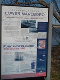
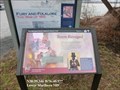 view gallery view gallerySE3.4 km | Town Ravaged Star-Spangled Banner National Historic Trail - Lower Marlboro, MD in Signs of History A British force of about 160 Royal Marines and 30 Colonial Marines (former slaves) took Lower Marlboro on June 15, 1814, without and resistance. posted by: Don.Morfe location: Maryland date approved: 08/30/2022 last visited: 08/30/2022 |
 view gallery view gallerySE3.4 km |  Town Ravaged Star-Spangled Banner National Historic Trail - Lower Marlboro, MD Town Ravaged Star-Spangled Banner National Historic Trail - Lower Marlboro, MD
in War of 1812 A British force of about 160 Royal Marines and 30 Colonial Marines (former slaves) took Lower Marlboro on June 15, 1814, without and resistance. posted by: Don.Morfe location: Maryland date approved: 03/04/2020 last visited: 11/02/2021 |
 view gallery view gallerySE3.5 km |  Lower Marlboro Town Lower Marlboro Town
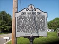
in Maryland Historical Markers This historical marker was placed by the Calvert County Historical Society and the Maryland Historical Society. It is located at the site of the old Lower Marlboro Church Hall. posted by:  redlights redlights location: Maryland date approved: 05/18/2008 last visited: 08/21/2021 |
 view gallery view gallery N5.8 km N5.8 km
|  Edgar A. Merkle Memorial - Merkle Wildlife Sanctuary - Upper Marlboro MD Edgar A. Merkle Memorial - Merkle Wildlife Sanctuary - Upper Marlboro MD
in Citizen Memorials The Edgar A. Merkle Memorial is on the grounds of the Merkle Wildlife Sanctuary located at 11704 Ferno Road, Upper Marlboro MD 20772 posted by: Don.Morfe location: Maryland date approved: 09/19/2023 last visited: 09/19/2023 |
 view gallery view galleryN5.8 km |  ONLY-wildlife sanctuary operated by the Maryland Department of Natural Resources Merkle Wildlife Sanctuary and Visitor's Center - Upper Marlboro MD- ONLY-wildlife sanctuary operated by the Maryland Department of Natural Resources Merkle Wildlife Sanctuary and Visitor's Center - Upper Marlboro MD-
in Superlatives Merkle Wildlife Sanctuary and Visitor's Center is located at 11704 Ferno Road, Upper Marlboro MD 20772 posted by: Don.Morfe location: Maryland date approved: 09/20/2023 last visited: 09/21/2023 |
 view gallery view galleryN5.8 km |  Merkle Wildlife Sanctuary - Upper Marlboro MD Merkle Wildlife Sanctuary - Upper Marlboro MD
in People-Named Places Merkle Wildlife Sanctuary and Visitor's Center is located at 11704 Ferno Road, Upper Marlboro MD 20772 posted by: Don.Morfe location: Maryland date approved: 09/21/2023 last visited: 09/21/2023 |
 view gallery view galleryN5.8 km |  Merkle Wildlife Sanctuary and Visitor's Center - Upper Marlboro MD Merkle Wildlife Sanctuary and Visitor's Center - Upper Marlboro MD
in National Wildlife Refuges Merkle Wildlife Sanctuary and Visitor's Center is located at 11704 Ferno Road, Upper Marlboro MD 20772 posted by: Don.Morfe location: Maryland date approved: 09/19/2023 last visited: 09/20/2023 |
 view gallery view galleryN5.8 km |  Merkle Wildlife Sanctuary and Visitor's Center - Upper Marlboro MD Merkle Wildlife Sanctuary and Visitor's Center - Upper Marlboro MD
in Wikipedia Entries Merkle Wildlife Sanctuary and Visitor's Center is located at 11704 Ferno Road, Upper Marlboro MD 20772 posted by: Don.Morfe location: Maryland date approved: 09/19/2023 last visited: 09/19/2023 |
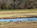
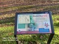
 view gallery view galleryN5.8 km |  Shaded Reprieve - Upper Marlboro MD Shaded Reprieve - Upper Marlboro MD
in Battlefields Marker is at the entrance road to Merkle Wildlife Sanctuary, Fenno Road,
Upper Marlboro, MD USA 20772. posted by: Don.Morfe location: Maryland date approved: 09/19/2023 last visited: 09/19/2023 |
 view gallery view galleryN5.8 km | Shaded Reprieve Star-Spangled Banner Historic Trail - Upper Marlboro MD in War of 1812 Well-shaded Fenno Road provided relief for sweltering British soldiers marching from Benedict. posted by: Don.Morfe location: Maryland date approved: 03/29/2020 last visited: 11/02/2021 |
 view gallery view gallery E6 km E6 km
| A County in Ruin Star-Spangled Banner National Historic Trail - Owings, MD in War of 1812 British raiding parties brought the war to Calvert County in 1814, destroying plantations and towns and carrying away the spoils. posted by: Don.Morfe location: Maryland date approved: 03/11/2020 last visited: 11/02/2021 |
 view gallery view galleryE6 km | A County in Ruin Star-Spangled Banner National Historic Trail - Owings, MD in Signs of History British raiding parties brought the war to Calvert County in 1814, destroying plantations and towns and carrying away the spoils. posted by: Don.Morfe location: Maryland date approved: 08/30/2022 last visited: 08/30/2022 |
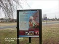 view gallery view galleryE6 km | A County in Ruin - Owings, MD in Battlefields The marker is located on the grounds of the Fairview Public Library and Visitor Center, Southern Maryland Blvd (SR 4),Owings, MD United States 20736 posted by: Don.Morfe location: Maryland date approved: 09/15/2023 last visited: 09/15/2023 |
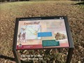
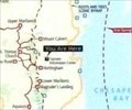 view gallery view galleryE6 km |  'You Are Here' Maps-A County in Ruin Star - Owings, MD 'You Are Here' Maps-A County in Ruin Star - Owings, MD
in 'You Are Here' Maps The 'You Are Here' Map shows that you are on the grounds of the Fairview Public Library and Visitor Center, Southern Maryland Blvd (SR 4),Owings, MD United States 20736 posted by: Don.Morfe location: Maryland date approved: 09/13/2023 last visited: 09/13/2023 |
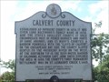 view gallery view galleryE6 km | CALVERT COUNTY (no. 1) in Maryland Historical Markers This historical marker is on the property of the Calvert County Welcome Center in Owings, MD, just off of Route 4. posted by: redlights location: Maryland date approved: 08/23/2008 last visited: 06/28/2012 |
 view gallery view gallery NE6.1 km NE6.1 km
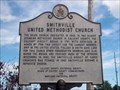
| SMITHVILLE UNITED METHODIST CHURCH in Maryland Historical Markers This is another historical marker located within Calvert County, Maryland. It is located just west of route 4 in Dunkirk, MD in front of the church. If you are visiting on Sundays please be respectful of the worshippers there. posted by: redlights location: Maryland date approved: 08/23/2008 last visited: 08/07/2013 |
 view gallery view galleryN8.2 km |  Croom's Historic Airport's Compass Rose Croom's Historic Airport's Compass Rose
in Compass Roses A beautiful Compas Rose located near the Croom's Historic Airport. posted by: LeGrandChrist location: Maryland date approved: 09/05/2014 last visited: 08/31/2014 |
 view gallery view gallery NW8.7 km NW8.7 km
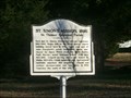
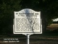
| St. Simon's Mission, 1896 in Maryland Historical Markers St. Simon's Mission, 1896 St. Thomas’ Episcopal Parish-Here met St. Simon's Mission for African-Americans 1902-1964. Begun 1896 by the Willes family, church building moved here in 1902. posted by: Don.Morfe location: Maryland date approved: 10/26/2019 last visited: 09/28/2021 |
 view gallery view galleryNW8.7 km |  St. Simon's Mission, 1896 - Upper Marlboro MD St. Simon's Mission, 1896 - Upper Marlboro MD
in Civil Rights Memorials St. Simon's Mission, 1896 St. Thomas’ Episcopal Parish-Here met St. Simon's Mission for African-Americans 1902-1964. Begun 1896 by the Willes family, church building moved here in 1902. posted by: Don.Morfe location: Maryland date approved: 10/16/2022 last visited: 10/16/2022 |
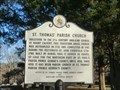 view gallery view galleryNW8.9 km | St. Thomas' Parish Church in Maryland Historical Markers St. Thomas' Parish Church-Successor to the 17th century Anglican Church at Mount Calvert, this cruciform, brick church was authorized in 1732 and completed in 1745. posted by: Don.Morfe location: Maryland date approved: 10/26/2019 last visited: 09/28/2021 |
 view gallery view galleryNW8.9 km | Enemy Bluff Star-Spangled Banner Historic Trail - Upper Marlboro MD in Signs of History On August 22, 1814, American Brigadier General William Winder Spotted the enemy invasion force approaching this church, then called Page Chapel. posted by: Don.Morfe location: Maryland date approved: 09/05/2022 last visited: 09/05/2022 |
 view gallery view galleryNW8.9 km | Enemy Bluff Star-Spangled Banner Historic Trail - Upper Marlboro MD in War of 1812 On August 22, 1814, American Brigadier General William Winder Spotted the enemy invasion force approaching this church, then called Page Chapel. The British marched west toward Bellefields, Woodyard, and Fort Washington, then doubled back before heading north to Upper Marlboro. posted by: Don.Morfe location: Maryland date approved: 03/29/2020 last visited: 11/02/2021 |
 view gallery view galleryNW8.9 km | Enemy Bluff - Upper Marlboro MD in Battlefields The marker is at 14300 Saint Thomas Church Rd, in front of Saint Thomas Episcopal Church, Upper Marlboro, MD United States 20772 posted by: Don.Morfe location: Maryland date approved: 09/19/2023 last visited: 09/19/2023 |
 view gallery view galleryNW8.9 km |  St. Thomas' Church - Upper Marlboro MD St. Thomas' Church - Upper Marlboro MD
in U.S. National Register of Historic Places The church was “Victorianized” in the 1850s and 1860s and a bell tower in memory of Bishop Claggett was added in 1888. The church was renovated in the 1950s to incorporate Victorian and Colonial elements within a harmonious design. posted by: Don.Morfe location: Maryland date approved: 09/11/2022 last visited: 09/05/2022 |
|