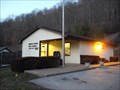
 view gallery view gallery NE6.6 km NE6.6 km
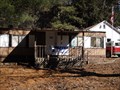
|   Chloe WV 25235 Post Office Chloe WV 25235 Post Office
in U.S. Post Offices Chloe WV 25235 Post Office posted by:  dukemartin dukemartin location: West Virginia date approved: 03/12/2013 last visited: never |
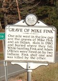 view gallery view galleryNE7.1 km |  Grave of Mike Fink Grave of Mike Fink
in West Virginia Historical Markers Grave of Mike Fink Calhoun Co. WV posted by:  two-bit Joe two-bit Joe location: West Virginia date approved: 02/12/2007 last visited: 03/09/2013 |
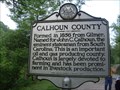 view gallery view gallery E7.1 km E7.1 km
| Calhoun / Clay County in West Virginia Historical Markers A two sided sign telling when and where the counties were formed from. posted by: Paintedwarrior location: West Virginia date approved: 05/28/2013 last visited: 06/01/2013 |
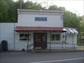 view gallery view galleryE8.5 km | Nebo WV 25141 Post office in U.S. Post Offices Nebo WV 25141 Post office posted by: dukemartin location: West Virginia date approved: 05/23/2013 last visited: never |
 view gallery view gallery N11.3 km N11.3 km
| Orma WV 25268 Post Office in U.S. Post Offices Orma WV 25268 Post Office posted by: dukemartin location: West Virginia date approved: 03/11/2013 last visited: never |
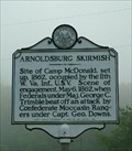 view gallery view galleryN14.2 km | Arnoldsburg Skirmish in West Virginia Historical Markers Arnoldsburg, WV Civil War Skirmish posted by: two-bit Joe location: West Virginia date approved: 02/12/2007 last visited: 10/04/2023 |
 view gallery view galleryN14.8 km | Arnoldsburg WV 25234 Post Office in U.S. Post Offices Arnoldsburg WV 25234 Post Office posted by: dukemartin location: West Virginia date approved: 03/11/2013 last visited: never |
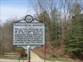
 view gallery view galleryN15.3 km |  Arnoldsburg Skirmish - Arnoldsburg, WV Arnoldsburg Skirmish - Arnoldsburg, WV
in American Civil War Monuments and Memorials Marker is located at the intersection of U.S. 33 and Arnoldsburg-Rocksdale Road, Arnoldsburg, WV in Calhoun County. posted by: Don.Morfe location: West Virginia date approved: 09/06/2023 last visited: 09/06/2023 |
 view gallery view galleryN15.3 km | Arnoldsburg Skirmish - Arnoldsburg, WV in West Virginia Historical Markers Site of Camp McDonald, set up, 1862, occupied by the 11th W. Va. Inf., U.S.V. posted by: Don.Morfe location: West Virginia date approved: 03/08/2020 last visited: 10/24/2021 |
 view gallery view galleryN15.3 km |  Arnoldsburg Skirmish - Arnoldsburg WV Arnoldsburg Skirmish - Arnoldsburg WV
in Battlefields Scene of engagement, May 6, 1862, when Federals under Maj. George C. Trimble beat off an attack by Confederate Moccasin Rangers under Capt. Geo. Downs. posted by: Don.Morfe location: West Virginia date approved: 11/21/2020 last visited: 10/16/2021 |
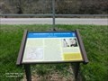 view gallery view galleryN15.3 km | Engagement at Arnoldsburg-Divided Loyalties - Arnoldsburg WV in U.S. Civil War Sites Early in 1862, the 11th West Virginia Infantry in Spencer established an outpost here in Arnoldsburg to suppress Confederate guerilla activity. Union Maj. George C. Trimble commanded four companies here at Camp McDonald. posted by: Don.Morfe location: West Virginia date approved: 07/01/2023 last visited: 07/01/2023 |
 view gallery view galleryN15.3 km | Engagement at Arnoldsburg Divided Loyalties - Arnoldsburg WV in Civil War Discovery Trail Sites Early in 1862, the 11th West Virginia Infantry in Spencer established an outpost here in Arnoldsburg to suppress Confederate guerilla activity. posted by: Don.Morfe location: West Virginia date approved: 08/12/2020 last visited: 10/05/2021 |
 view gallery view galleryN16.4 km | Millstone WV 25261 Post Office in U.S. Post Offices Millstone WV 25261 Post Office posted by: dukemartin location: West Virginia date approved: 03/11/2013 last visited: never |
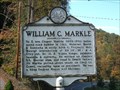 view gallery view gallery S19 km S19 km
| William C. Markle in West Virginia Historical Markers William C. Markle located near Clay posted by: two-bit Joe location: West Virginia date approved: 01/09/2009 last visited: 08/04/2012 |
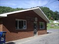 view gallery view galleryS19 km | Maysel, WV. 25133 in U.S. Post Offices Maysel WV Post Office posted by: dukemartin location: West Virginia date approved: 08/08/2012 last visited: never |
 view gallery view gallery SW19.5 km SW19.5 km
|  23 SKS 23 SKS
in U.S. Benchmarks 23 SKS near Clio, Roane County, WV. posted by: two-bit Joe location: West Virginia date approved: 03/22/2007 last visited: never |
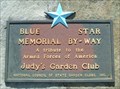 view gallery view galleryE20.9 km |  I79 Northbound - Near Frametown, WV I79 Northbound - Near Frametown, WV
in Blue Star Memorial Highway Markers Blue Star Memorial marker located at the northbound rest area on Interstate 79, between the Frametown (Exit 51) and Servia Road (Exit 46) exits in Braxton County, West Virginia. posted by: Cache Sleuth location: West Virginia date approved: 04/30/2009 last visited: 08/13/2011 |
 view gallery view galleryS22.2 km | Clay, WV. 25043 in U.S. Post Offices Clay WV Post Office posted by: dukemartin location: West Virginia date approved: 08/08/2012 last visited: never |
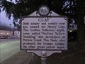 view gallery view galleryS22.4 km | Clay in West Virginia Historical Markers A sign telling about about apples produced in West Virginia. posted by: dukemartin location: West Virginia date approved: 12/20/2018 last visited: never |
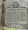 view gallery view galleryNE22.9 km |  Calhoun County - Stumptown WV Calhoun County - Stumptown WV
in People-Named Places Calhoun County was formed in 1856 and it was named after John C. Calhoun an eminent statesman from South Carolina. posted by: Don.Morfe location: West Virginia date approved: 03/11/2023 last visited: 03/09/2023 |
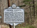 view gallery view galleryNE22.9 km | Gilmer County - Calhoun County / Gilmer County Line, WV in People-Named Places Gilmer County-Formed, 1845, from Kanawha and Lewis. Named for Thomas Walker Gilmer. Secretary of the Navy in President Tyler's Cabinet, who wad killed by the explosion of a gun on board the United States battleship, Princeton, February 28, 1844. posted by: Don.Morfe location: West Virginia date approved: 03/11/2023 last visited: 03/05/2023 |
 view gallery view galleryNE22.9 km |  U.S.S Princeton Explosion -marker for Gilmer County - Arnoldsburg WV U.S.S Princeton Explosion -marker for Gilmer County - Arnoldsburg WV
in Disaster Memorials Gilmore County WV named for Thomas Walker Gilmer, Secretary of the Navy in President Tyler's Cabinet, who wad killed by the explosion of a gun on board the United States battleship, Princeton, February 28, 1844. posted by: Don.Morfe location: West Virginia date approved: 03/04/2023 last visited: 03/05/2023 |
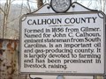 view gallery view galleryNE22.9 km | Calhoun County / Gilmer County in West Virginia Historical Markers A two sided sign telling us from where the counties were formed. posted by: Paintedwarrior location: West Virginia date approved: 03/11/2013 last visited: 03/05/2023 |
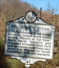 view gallery view gallery W23.2 km W23.2 km
| Pocatalico River in West Virginia Historical Markers Pocatalico River in Walton, WV posted by: two-bit Joe location: West Virginia date approved: 09/08/2006 last visited: 04/05/2018 |
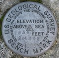 view gallery view galleryS24.5 km | Bomont Church Benchmark in U.S. Benchmarks Benchmark Disk found using USGS datasheet description. posted by: frex3wv location: West Virginia date approved: 12/30/2007 last visited: never |
|