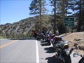
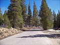
 view gallery view gallery SW13.2 km SW13.2 km
|   Sonora Pass, Elev 9624 Ft Sonora Pass, Elev 9624 Ft
in Elevation Signs Sonora Pass, Highway 108, Sierra Nevada Range, California posted by:  michael3900 michael3900 location: California date approved: 09/17/2008 last visited: 09/11/2011 |
 view gallery view gallery N16.1 km N16.1 km
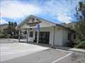
|  Coleville, CA - 96107 Coleville, CA - 96107
in U.S. Post Offices A post office in the small community of Coleville, CA. Coleville is located in Mono County. posted by:  saopaulo1 saopaulo1 location: California date approved: 05/16/2011 last visited: 10/25/2018 |
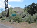
 view gallery view galleryN16.1 km | Coleville, CA - 5,160 Ft in Elevation Signs A sign as you're entering the community of Coleville in Mono county. posted by: saopaulo1 location: California date approved: 05/17/2011 last visited: 07/13/2013 |
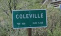
 view gallery view galleryN16.1 km |  Coleville, CA - Pop: 400 Coleville, CA - Pop: 400
in Population Signs A sign as you're entering the community of Coleville in Mono county. posted by: saopaulo1 location: California date approved: 05/17/2011 last visited: 07/13/2013 |
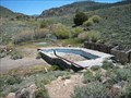 view gallery view gallery SE17.5 km SE17.5 km
|  Fales Hot Springs Fales Hot Springs
in Hot Springs Abandoned resort off of Hwy 395 in Mono County. posted by: Squirreleen location: California date approved: 04/28/2008 last visited: 06/27/2012 |
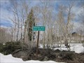
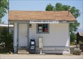 view gallery view galleryN20.1 km | Topaz, CA 96133 in U.S. Post Offices A tiny post office in a tiny town. posted by: Free2bme29 location: California date approved: 07/09/2009 last visited: 09/01/2021 |
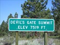 view gallery view gallerySE20.4 km | Devil's Gate Summit 7519 Feet - CA in Elevation Signs Devil's Gate Pass is located in Mono County, CA. This is the highest point on that pass. posted by: Free2bme29 location: California date approved: 07/11/2009 last visited: 09/14/2021 |
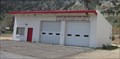 view gallery view galleryN21.6 km |  Antelope Valley Fire District - Topaz Station 2 Antelope Valley Fire District - Topaz Station 2
in Firehouses Station 2 of the Antelope Valley Fire District is located in Topaz, CA. posted by: saopaulo1 location: California date approved: 05/17/2011 last visited: never |
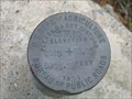 view gallery view gallery W22.5 km W22.5 km
|  Clark Fork Rd Clark Fork Rd
in U.S. Benchmarks USDA Bureau of Public Roads disk posted by: dmchapman location: California date approved: 01/29/2006 last visited: 05/07/2011 |
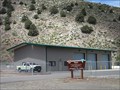 view gallery view galleryN23.3 km | Topaz Interagency Fire Control Station in Firehouses The Topz Interagency Fire Control Station is located in Topaz, CA. It's run by the USDA and BLM. posted by: saopaulo1 location: California date approved: 05/17/2011 last visited: never |
 view gallery view gallery NW24.3 km NW24.3 km
|  Ebbetts Pass Route, SHL No. 318 Ebbetts Pass Route, SHL No. 318
in California Historical Markers One of the oldest and most scenic passes across the Sierra Nevada posted by: Bernd das Brot Team location: California date approved: 06/06/2008 last visited: never |
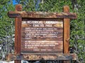
 view gallery view galleryNW24.3 km |  Carson-Iceberg Wilderness, California Carson-Iceberg Wilderness, California
in Public Access Lands Alpine wilderness at the crest of the Sierra Nevada posted by: Bernd das Brot Team location: California date approved: 06/08/2008 last visited: never |
 view gallery view galleryNW24.3 km |  Ebbetts Pass Scenic Byway - Ebbetts Pass, Elevation 8,730 ft Ebbetts Pass Scenic Byway - Ebbetts Pass, Elevation 8,730 ft
in National Scenic Byways The highest point of California's State Route No. 4 posted by: Bernd das Brot Team location: California date approved: 05/31/2008 last visited: 07/07/2012 |
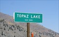 view gallery view galleryN26.1 km | Topaz Lake, CA - 5050 Feet in Elevation Signs There's a pull-out on the road where you can stop and look at the lake while getting this waymark! posted by: Free2bme29 location: California date approved: 07/06/2009 last visited: 09/14/2021 |
 view gallery view galleryN26.4 km | Eastern Sierra Scenic Byway - Topaz Lake, CA in National Scenic Byways Lake along US Hwy 395 posted by: Bernd das Brot Team location: California date approved: 05/20/2008 last visited: 09/24/2011 |
 view gallery view galleryN27 km |  Monitor Pass Monitor Pass
in Wikipedia Entries Monitor Pass is one of the highest points in the Sierras. posted by: saopaulo1 location: California date approved: 05/17/2011 last visited: 06/01/2012 |
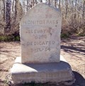 view gallery view galleryN27 km | Monitor Pass, CA - 8,314 ft in Elevation Signs One of the highest passes across the Sierra Nevada posted by: Bernd das Brot Team location: California date approved: 05/31/2008 last visited: 10/25/2018 |
 view gallery view galleryN27 km | Ebbetts Pass Scenic Byway - Monitor Pass in National Scenic Byways The eastern entrance to Ebbetts Pass Scenic Byway posted by: Bernd das Brot Team location: California date approved: 05/31/2008 last visited: 06/01/2012 |
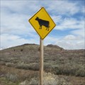 view gallery view galleryN27.4 km |  Cow Crossing - Mono County, CA Cow Crossing - Mono County, CA
in Uncommon Crossing Signs This cow crossing is on Hway 89 in Mono County, CA. It's at the Mono/Alpine county borders. posted by: saopaulo1 location: California date approved: 05/23/2011 last visited: never |
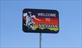 view gallery view galleryN28.2 km |  CA/NV 395 North CA/NV 395 North
in Border Crossings Welcome to Nevada. When heading north on 395 in California, you cross the border near Topaz Lake. posted by: Free2bme29 location: Nevada date approved: 07/15/2009 last visited: 07/12/2012 |
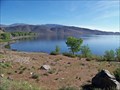
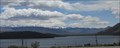 view gallery view galleryN28.3 km | Topaz Lake in Wikipedia Entries Topaz Lake is a resevoir that straddles the states of California and Nevada. posted by: saopaulo1 location: Nevada date approved: 06/09/2011 last visited: 09/24/2011 |
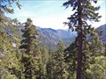
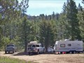 view gallery view galleryW30.3 km |  Hermit Valley Turnout, Highway 4, California Hermit Valley Turnout, Highway 4, California
in Free Overnight RV Parking Locations Turnout and parking along Mokelumne River in the Sierra Nevada posted by: Bernd das Brot Team location: California date approved: 06/02/2008 last visited: 06/10/2012 |
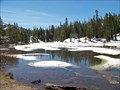 view gallery view galleryW31.1 km | Ebbetts Pass Scenic Byway - Mosquito Lakes in National Scenic Byways One of the many scenic lakes along this Scenic Byway posted by: Bernd das Brot Team location: California date approved: 05/31/2008 last visited: 07/07/2012 |
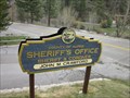 view gallery view galleryNW34.1 km |  Alpine County Sheriff- Markleeville, CA Alpine County Sheriff- Markleeville, CA
in Police Stations The Alpine County Sheriff's headquarters is located in the county courthouse on Hway 89 in Markleeville, CA. posted by: saopaulo1 location: California date approved: 05/17/2011 last visited: never |
 view gallery view galleryNW34.1 km | Marklee's Cabin Site - Markleeville, CA in California Historical Markers The Marklee's Cabin Site is located where the county courthouse is located. posted by: saopaulo1 location: California date approved: 05/21/2011 last visited: never |
|