|
 Carson-Iceberg Wilderness, California
N 38° 32.642 W 119° 48.738
11S E 254900 N 4269929
Alpine wilderness at the crest of the Sierra Nevada
Waymark Code: WM3YT8
Location: California, United States
Date Posted: 06/07/2008
Views: 62
 Click on any picture for larger images.
Click the green links for more information and the blue links for other nearby waymarks.
|
The Carson-Iceberg Wilderness was established in 1984 and encompasses a total of 161,181 acres. The eastern half is part of Toiyabe National Forest while the western half belongs to Stanislaus National Forest. It is named after two signature features within its borders, the Carson River and a distinctive granite formation called the Iceberg on the southern boundary.
The Pacific Crest Trail runs across this wilderness for over 26 miles. In addition, there are 200 more miles of foot and horse trails, making this an outstanding and enjoyable experience.
Click here for a general map of the area and here for a trail map.
|
|
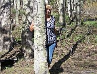
The two National Forests are divided by the crest of the Sierra Nevada. They also represent two distinctively different watersheds. The Toiyabe forest is part of the Carson River Watershed, which empties into the enclosed Carson Sink in Nevada, while the Stanislaus Forest belongs to the Mokelumne River watershed, with water eventually ending up in the Pacific Ocean. Here, on top of the Sierra Nevada, at Ebbetts Pass we found a tree that had half of its roots in one and half of its roots in the other watershed. (see pictures above). We couldn't find a fitting waymark category for this oddball amongst trees, so we mention it here.
|
Vegetation in this area is dominated by pines and firs and wildlife includes all of the common Sierra Nevada species, from squirrels to black bears. It is a common saying in the Sierra that even if you might never see a bear, there is always a bear watching you.
The only wildlife we were lucky enough to observe was a Yellow-Bellied Marmot
(see pictures below).
|
West of Ebbetts Pass are the headwaters of the Mokelumne River
 |
|
The whole area is in spectacular high country, with 12 peaks rising above 12,000 feet and numerous other peaks over 9,000 feet.
At this altitude, expect ice and snow from September until June!
|
|
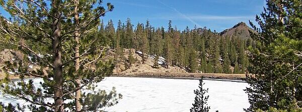
Kinney Reservoir near Ebbetts Pass in late May
Estimated size of the public land (in regional measurement standard: hectares, acres, kms, etc.): 160,000 acre

Is there a trail system?: Yes
If there is a trail system, please describe length, terrain, etc.:
200 miles of trails, including a part of the Pacific Crest Trail. See trail map link in main article for details:
What points of interest are there?:
wild rivers and volcanic ridges and peaks
What activities are available?:
hiking, cross country skiing/snowshoeing,
List of known hazards (cliffs, snakes, poison plants, etc.):
cold weather, bears, poison oak
Dogs Allowed?: Yes
Is a permit/fee required?: Yes
If a permit/fee is required please describe in detail how to get one, how much, etc.:
A Wilderness Visitor's Permit is required for overnight visits
Please supply the website of the land if available: [Web Link]
Hours of accessibility?: Not listed
|
Visit Instructions:
Visitors are encouraged to supply a picture of either themselves or their GPS at the trailhead and/or signage of the public access lands - describe your experience there and what you saw - tell us why other folks should come visit!
Recent Visits/Logs:
| There are no logs for this waymark yet. |
|
|
|
|