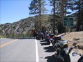
 view gallery view gallery S2.9 km S2.9 km
|   Sonora Pass, Elev 9624 Ft Sonora Pass, Elev 9624 Ft
in Elevation Signs Sonora Pass, Highway 108, Sierra Nevada Range, California posted by:  michael3900 michael3900 location: California date approved: 09/17/2008 last visited: 09/11/2011 |
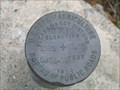 view gallery view gallery W16.6 km W16.6 km
|  Clark Fork Rd Clark Fork Rd
in U.S. Benchmarks USDA Bureau of Public Roads disk posted by:  dmchapman dmchapman location: California date approved: 01/29/2006 last visited: 05/07/2011 |
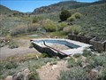 view gallery view gallery E20.4 km E20.4 km
|  Fales Hot Springs Fales Hot Springs
in Hot Springs Abandoned resort off of Hwy 395 in Mono County. posted by: Squirreleen location: California date approved: 04/28/2008 last visited: 06/27/2012 |
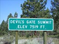 view gallery view galleryE23.7 km | Devil's Gate Summit 7519 Feet - CA in Elevation Signs Devil's Gate Pass is located in Mono County, CA. This is the highest point on that pass. posted by: Free2bme29 location: California date approved: 07/11/2009 last visited: 09/14/2021 |
 view gallery view gallery NW26.2 km NW26.2 km
|  Ebbetts Pass Route, SHL No. 318 Ebbetts Pass Route, SHL No. 318
in California Historical Markers One of the oldest and most scenic passes across the Sierra Nevada posted by: Bernd das Brot Team location: California date approved: 06/06/2008 last visited: never |
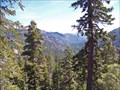 view gallery view galleryNW26.2 km |  Carson-Iceberg Wilderness, California Carson-Iceberg Wilderness, California
in Public Access Lands Alpine wilderness at the crest of the Sierra Nevada posted by: Bernd das Brot Team location: California date approved: 06/08/2008 last visited: never |
 view gallery view galleryNW26.2 km |  Ebbetts Pass Scenic Byway - Ebbetts Pass, Elevation 8,730 ft Ebbetts Pass Scenic Byway - Ebbetts Pass, Elevation 8,730 ft
in National Scenic Byways The highest point of California's State Route No. 4 posted by: Bernd das Brot Team location: California date approved: 05/31/2008 last visited: 07/07/2012 |
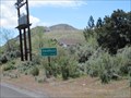
 view gallery view gallery NE26.6 km NE26.6 km
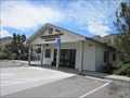
|  Coleville, CA - 96107 Coleville, CA - 96107
in U.S. Post Offices A post office in the small community of Coleville, CA. Coleville is located in Mono County. posted by: saopaulo1 location: California date approved: 05/16/2011 last visited: 10/25/2018 |
 view gallery view galleryNE26.6 km | Coleville, CA - 5,160 Ft in Elevation Signs A sign as you're entering the community of Coleville in Mono county. posted by: saopaulo1 location: California date approved: 05/17/2011 last visited: 07/13/2013 |
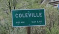
 view gallery view galleryNE26.6 km |  Coleville, CA - Pop: 400 Coleville, CA - Pop: 400
in Population Signs A sign as you're entering the community of Coleville in Mono county. posted by: saopaulo1 location: California date approved: 05/17/2011 last visited: 07/13/2013 |
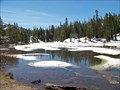 view gallery view galleryNW30.1 km | Ebbetts Pass Scenic Byway - Mosquito Lakes in National Scenic Byways One of the many scenic lakes along this Scenic Byway posted by: Bernd das Brot Team location: California date approved: 05/31/2008 last visited: 07/07/2012 |
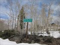
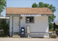 view gallery view gallery N30.3 km N30.3 km
| Topaz, CA 96133 in U.S. Post Offices A tiny post office in a tiny town. posted by: Free2bme29 location: California date approved: 07/09/2009 last visited: 09/01/2021 |
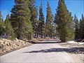
 view gallery view galleryNW30.4 km |  Hermit Valley Turnout, Highway 4, California Hermit Valley Turnout, Highway 4, California
in Free Overnight RV Parking Locations Turnout and parking along Mokelumne River in the Sierra Nevada posted by: Bernd das Brot Team location: California date approved: 06/02/2008 last visited: 06/10/2012 |
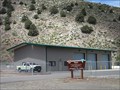
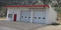 view gallery view galleryN31.7 km |  Antelope Valley Fire District - Topaz Station 2 Antelope Valley Fire District - Topaz Station 2
in Firehouses Station 2 of the Antelope Valley Fire District is located in Topaz, CA. posted by: saopaulo1 location: California date approved: 05/17/2011 last visited: never |
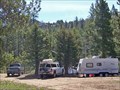
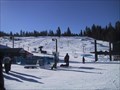
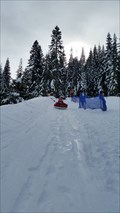 view gallery view gallery SW32.8 km SW32.8 km
|  Leland High Sierra Snow Play - Pinecrest, CA Leland High Sierra Snow Play - Pinecrest, CA
in Sledding Places A sledding park in Pinecrest, CA. posted by: saopaulo1 location: California date approved: 01/26/2016 last visited: never |
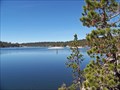
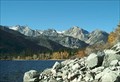 view gallery view gallery SE33.3 km SE33.3 km
|  Crag's Resort, Lower Twin Lake- Bridgeport, CA Crag's Resort, Lower Twin Lake- Bridgeport, CA
in Fishing Holes Lower Twin Lakes Crag's Resort, in large Jeffrey pine trees and sagebrush. Trophy trout are taken annually from Lower Twin Lake, one of the premier fishing lakes in Mono County. posted by: calgriz location: California date approved: 01/21/2010 last visited: 07/10/2010 |
 view gallery view galleryN33.5 km | Topaz Interagency Fire Control Station in Firehouses The Topz Interagency Fire Control Station is located in Topaz, CA. It's run by the USDA and BLM. posted by: saopaulo1 location: California date approved: 05/17/2011 last visited: never |
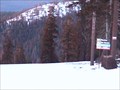 view gallery view gallerySW33.5 km |  Dodge Ridge Ski Area Dodge Ridge Ski Area
in Web Cameras Two controllable webcams available 24/7. posted by: dmchapman location: California date approved: 01/17/2007 last visited: 02/27/2008 |
 view gallery view gallerySW33.5 km |  Dodge Ridge Dodge Ridge
in Winter Sports Locations Dodge Ridge near Pinecrest California in the Sierra Nevada. posted by: dmchapman location: California date approved: 02/01/2006 last visited: never |
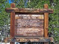
 S34 km |  Yosemite an enduring Treasure CA Yosemite an enduring Treasure CA
in There's a Book About It The cover photo is Upper Yosemite Falls but you can log within the range.
A 10" x 12" color paperback, 50 pgs. 2001 by the Yosemite Association. posted by: sbcamper location: California date approved: 07/09/2009 last visited: 03/30/2014 |
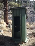 view gallery view gallerySE34 km |  Twin Lake, Bridgeport, California Twin Lake, Bridgeport, California
in Outhouses Rest Stop on the hill.. posted by: grandmabetsy location: California date approved: 03/02/2014 last visited: 03/02/2014 |
 view gallery view galleryNW34.4 km | Ebbetts Pass Scenic Byway - Lake Alpine in National Scenic Byways An alpine lake called Lake Alpine posted by: Bernd das Brot Team location: California date approved: 05/31/2008 last visited: 07/07/2012 |
 view gallery view galleryNW34.9 km |  Lake Alpine Resort - Bear Valley, California Lake Alpine Resort - Bear Valley, California
in Chalet, Cottage, and Cabin Style Lodging Lake Alpine Resort offers cabin rentals year round, however, the real treat is to take the snow cat ride into the remote lodge during the winter time. posted by: Touchstone location: California date approved: 02/18/2009 last visited: never |
 view gallery view galleryN35.7 km |  Monitor Pass Monitor Pass
in Wikipedia Entries Monitor Pass is one of the highest points in the Sierras. posted by: saopaulo1 location: California date approved: 05/17/2011 last visited: 06/01/2012 |
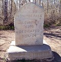 view gallery view galleryN35.7 km | Monitor Pass, CA - 8,314 ft in Elevation Signs One of the highest passes across the Sierra Nevada posted by: Bernd das Brot Team location: California date approved: 05/31/2008 last visited: 10/25/2018 |
|