 view gallery view gallery SW0 km SW0 km
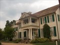
|   Belmont aka Gari Melchers Home - Falmouth, VA Belmont aka Gari Melchers Home - Falmouth, VA
in U.S. National Register of Historic Places The estate of this famous 19th century artist sits on a ridge in Falmouth overlooking the Rappahannock River. posted by:  La de Boheme La de Boheme location: Virginia date approved: 08/08/2007 last visited: 09/14/2013 |
 view gallery view gallery N0 km N0 km
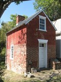
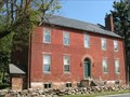
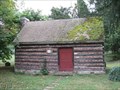
|  Caretaker Cottage-Gari Melchers Home and Studio - Fredericksburg, Virginia Caretaker Cottage-Gari Melchers Home and Studio - Fredericksburg, Virginia
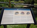
in Signs of History From construction of the main house ca. 1880, until the end of the Civil War, life at Belmont was intertwined with the institution of slavery. An 1815 Falmouth property list shows that then resident Susannah Knox owned four slaves over age 12. posted by: Don.Morfe location: Virginia date approved: 09/06/2020 last visited: 09/26/2021 |
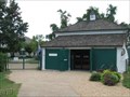 view gallery view galleryN0 km |  Marguerite Stroh Building - Stafford County Visitor Center Marguerite Stroh Building - Stafford County Visitor Center
in Tourist Information Centers - Visitor Centers Stafford's Visitor Center is located at historic Belmont in Falmouth, VA. posted by: La de Boheme location: Virginia date approved: 08/19/2009 last visited: never |
 view gallery view gallery E0.3 km E0.3 km
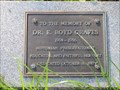
|  Dr. E. Boyd Graves - Fredericksburg, VA Dr. E. Boyd Graves - Fredericksburg, VA
in Citizen Memorials Dr. E. Boyd Graves was a preservationist and historian from Fredericksburg, Virginia. posted by:  DougK DougK location: Virginia date approved: 05/10/2011 last visited: never |
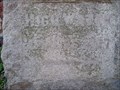 view gallery view galleryE0.3 km |  High Water, April 26, 1937, Falmouth, VA High Water, April 26, 1937, Falmouth, VA
in High Level Marks Rappahannock River water level marker for the April 26, 1937 flood. posted by: garmin_geek location: Virginia date approved: 02/25/2009 last visited: 04/15/2011 |
 view gallery view galleryE0.3 km |  Customs House - Falmouth Historic District - Stafford County VA Customs House - Falmouth Historic District - Stafford County VA
in NRHP Historic Districts - Contributing Buildings The Customs House is the oldest muncipal building in Stafford County, VA. posted by: La de Boheme location: Virginia date approved: 09/28/2010 last visited: 04/15/2011 |
 view gallery view galleryE0.3 km | Falmouth Historic District - Falmouth, VA in U.S. National Register of Historic Places Falmouth is situated on the north shore of the Rappahannock River, opposite the city of Fredericksburg. The Falmouth Historic District consists of 38 buildings in an area of 2250 acres. posted by: DougK location: Virginia date approved: 05/31/2011 last visited: 06/01/2011 |
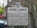
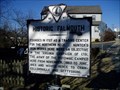 view gallery view galleryE0.3 km |  Historic Falmouth Historic Falmouth
in Virginia Historical Markers Virginia Historical marker E-47, Falmouth, VA posted 1927 posted by: garmin_geek location: Virginia date approved: 02/25/2009 last visited: 04/15/2011 |
 view gallery view gallery SE0.5 km SE0.5 km
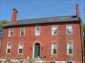
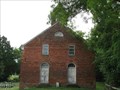
| Conway House - Falmouth VA in U.S. National Register of Historic Places The house was the home of famous abolitionist, Moncure Daniel Conway, and was used as a hospital and winter quarters for Union troops during the Civil War. posted by: La de Boheme location: Virginia date approved: 09/22/2009 last visited: never |
 view gallery view gallerySE0.5 km |  Moncure Conway House - Falmouth VA, USA Moncure Conway House - Falmouth VA, USA
in Pre-Victorian Historic Homes The Conway House was built in the Federal style in 1807 and was home to famous abolitionist, Moncure Conway. posted by: La de Boheme location: Virginia date approved: 10/11/2009 last visited: never |
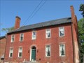
 view gallery view gallerySE0.5 km |  Moncure Conway House - Falmouth, VA Moncure Conway House - Falmouth, VA
in Underground Railroad Sites The significance of this site is its association with Moncure Conway who helped over 40 of the family's slaves escape to freedom by accompanying them to Ohio. posted by: La de Boheme location: Virginia date approved: 09/20/2009 last visited: never |
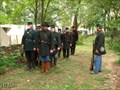 view gallery view gallerySE0.5 km |  Yankees In Falmouth - Falmouth VA USA Yankees In Falmouth - Falmouth VA USA
in Historic Reenactments Yankee soldiers first came to Falmouth in 1862 during the Civil War and they return every September, along with some Rebel soldiers. posted by: La de Boheme location: Virginia date approved: 09/26/2010 last visited: 09/17/2011 |
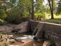 view gallery view gallerySW0.5 km |  Historic Old Mill District Dam Historic Old Mill District Dam
in Water Dams This concrete dam, built in 1907 on the Rappahannock River in Fredericksburg, replaced an older one and was said to be state-of-the-art. posted by: La de Boheme location: Virginia date approved: 09/22/2007 last visited: 05/14/2019 |
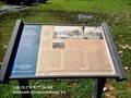 view gallery view gallerySE0.5 km |  Freedom Began Here-Trail to Freedom - Falmouth VA Freedom Began Here-Trail to Freedom - Falmouth VA
in U.S. Civil War Sites On April 18, 1862, advancing Federal forces reached the banks of the Rappahannock River. African-American slaves realized that this armed presence altered their accustomed social controls and many took the initiative to escape bondage. posted by: Don.Morfe location: Virginia date approved: 09/06/2020 last visited: 10/04/2021 |
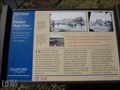 view gallery view gallerySE0.5 km | Trail To Freedom - Falmouth VA in Signs of History A historical sign in Stafford County, Virginia marks where slaves crossed the Rappahannock River to the safety of the Union army encampment on the Trail to Freedom. posted by: La de Boheme location: Virginia date approved: 03/16/2012 last visited: never |
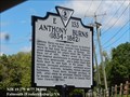 view gallery view gallerySE0.5 km | Anthony Burns (1834 ~ 1862) in Virginia Historical Markers Anthony Burns was born into slavery in Stafford County. In 1854 Burns escaped from Richmond, where he had been hired out, to Boston. posted by: Don.Morfe location: Virginia date approved: 03/13/2020 last visited: 10/20/2021 |
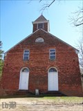 view gallery view galleryE0.5 km | Union Church and Cemetery - Stafford County VA in U.S. National Register of Historic Places The facade of an old church built in 1819 is a part of the cultural history of Falmouth, VA. posted by: La de Boheme location: Virginia date approved: 03/13/2012 last visited: 07/12/2013 |
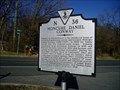 view gallery view gallerySE0.5 km | Moncure Daniel Conway in Virginia Historical Markers Virginia Historical Highway Marker, N-36 Moncure Daniel Conway, Falmouth, VA. Placed 2004 posted by: garmin_geek location: Virginia date approved: 02/25/2009 last visited: 07/13/2013 |
 view gallery view galleryE0.5 km | Union Church - Falmouth Historic District - Stafford County VA in NRHP Historic Districts - Contributing Buildings The Union Church is just a façade today, although a contributing structure to the Falmouth Historic District. posted by: La de Boheme location: Virginia date approved: 09/29/2007 last visited: 05/31/2015 |
 view gallery view gallery S0.5 km S0.5 km
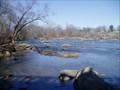
|  Rappahannock River Fall Line ~ Fredericksburg, VA Rappahannock River Fall Line ~ Fredericksburg, VA
in Places of Geologic Significance The fall line, the point where the Rappahannock becomes tidal. A major barrier for man and fish. Is crossed by U.S Route 1, the Jefferson Davis Hwy. posted by: garmin_geek location: Virginia date approved: 03/24/2009 last visited: 06/19/2010 |
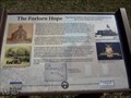 view gallery view galleryE0.5 km | The Forlorn Hope - Falmouth VA in Signs of History During the Civil War, in 1862, the 7th MI Infantry succeeded in holding the Confederate defenders back while the Union army built pontoon bridges to cross the Rappahannock into Fredericksburg, VA. However, the Federals ended up losing the battle. posted by: La de Boheme location: Virginia date approved: 03/16/2012 last visited: never |
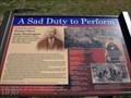 view gallery view galleryE0.5 km | A Sad Duty to Perform - Falmouth VA in Signs of History A historical marker at a church in Falmouth, VA tells of a Union funeral during the early years of the Civil War. posted by: La de Boheme location: Virginia date approved: 03/19/2012 last visited: 05/31/2015 |
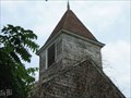 view gallery view galleryE0.5 km |  Union Church Belfry Union Church Belfry
in Bell Towers The church is just a facade today, but its belfry still stands on top. posted by: La de Boheme location: Virginia date approved: 07/20/2009 last visited: never |
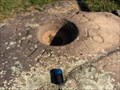 view gallery view gallerySW0.5 km |  Indian Punch Bowl Indian Punch Bowl
in New World Ancient Evidence This stone basin is said to have been used by Indians as a punch bowl during hunting festivals. posted by: La de Boheme location: Virginia date approved: 09/28/2007 last visited: 05/14/2019 |
 view gallery view galleryE0.5 km |  Hobby School - Falmouth VA Hobby School - Falmouth VA
in Former Schools A one-room log cabin schoolhouse from colonial times stands in historic Falmouth, VA. posted by: La de Boheme location: Virginia date approved: 10/10/2009 last visited: never |
|