  SW1.9 km SW1.9 km
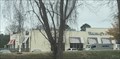
|   Cemetary in San Souci Plaza Cemetary in San Souci Plaza
in Out of Place Graves This small graveyard is located in San Souci Plaza, a large shopping center in California,MD. posted by:  full force48 full force48 location: Maryland date approved: 03/04/2006 last visited: 04/04/2012 |
 view gallery view gallery NE2.4 km NE2.4 km
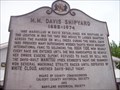
|  M.M. Davis Shipyard M.M. Davis Shipyard
in Maryland Historical Markers A historical marker on the east side of Route 2 in Solomons Island, Maryland. posted by:  redlights redlights location: Maryland date approved: 05/28/2007 last visited: never |
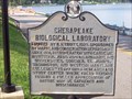 view gallery view galleryNE2.6 km | CHESAPEAKE BIOLOGICAL LABORATORY in Maryland Historical Markers This marker sits in front of the Chesapeake Biological Laboratories in Solomon's Island, MD. posted by: redlights location: Maryland date approved: 07/01/2008 last visited: 11/11/2011 |
 view gallery view gallerySW2.6 km |  Wendy's - Route 235 - California, MD Wendy's - Route 235 - California, MD
in Wendy's Restaurants A Wendy's in California, Maryland. posted by: bluesnote location: Maryland date approved: 12/20/2021 last visited: never |
 view gallery view gallerySW2.6 km |  Applebees - Route 235 - California, MD Applebees - Route 235 - California, MD
in Applebee's Restaurants An Applebees in California, Maryland. posted by: bluesnote location: Maryland date approved: 12/22/2021 last visited: never |
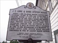 view gallery view galleryNE2.6 km | J.C. Lore & Sons Oyster House in Maryland Historical Markers Another historical sign along the east side of Route 2, in front of the Calvert Marine Museum's exhibit at the Lore Oyster House. posted by: redlights location: Maryland date approved: 05/28/2007 last visited: 07/09/2011 |
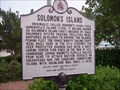 view gallery view galleryNE2.6 km | Solomon's Island in Maryland Historical Markers A historical marker placed by the historical societies of Calvert County and Maryland. Looked on the west side of Route 2 just as you cross on the island. posted by: redlights location: Maryland date approved: 05/28/2007 last visited: 05/25/2017 |
 view gallery view gallery W2.6 km W2.6 km
|  Patuxent Beach Road Barn - California, MD Patuxent Beach Road Barn - California, MD
in Painted Barn Quilts A barn quilt in California, Maryland. posted by: bluesnote location: Maryland date approved: 12/19/2021 last visited: never |
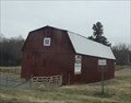 view gallery view galleryW2.6 km |  Patuxent Beach Road Barn - California, MD Patuxent Beach Road Barn - California, MD
in Barns A barn in California, Maryland. posted by: bluesnote location: Maryland date approved: 12/19/2021 last visited: never |
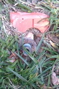 view gallery view galleryNE2.7 km |  Calvert County Survey Monument Map 46 Grid 5 Calvert County Survey Monument Map 46 Grid 5
in U.S. Benchmarks Solomons Island County triangulation disk posted by: Saint Ro location: Maryland date approved: 04/24/2010 last visited: never |
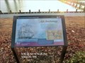
 view gallery view galleryNE2.7 km |  Enemy Blockade Star-Spangled Banner National Historic Trail - Solomons MD Enemy Blockade Star-Spangled Banner National Historic Trail - Solomons MD
in War of 1812 British warships blockaded the mouth of the Patuxent River after the Chesapeake Flotilla and Royal Navy skirmished off Cedar Point to the south June 1, 1814. posted by: Don.Morfe location: Maryland date approved: 03/19/2020 last visited: 11/02/2021 |
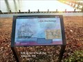
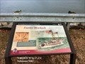 view gallery view galleryNE2.7 km |  Enemy Blockade Star-Spangled Banner National Historic Trail - Solomons MD Enemy Blockade Star-Spangled Banner National Historic Trail - Solomons MD
in Signs of History British warships blockaded the mouth of the Patuxent River after the Chesapeake Flotilla and Royal Navy skirmished off Cedar Point to the south June 1, 1814. posted by: Don.Morfe location: Maryland date approved: 08/31/2022 last visited: 08/31/2022 |
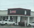 view gallery view galleryW2.7 km |  Dunkin' Donuts - Route 235 - California, MD Dunkin' Donuts - Route 235 - California, MD
in Dunkin Donuts' A Dunkin' Donuts in California, Maryland. posted by: bluesnote location: Maryland date approved: 12/19/2021 last visited: never |
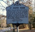 view gallery view galleryW2.7 km | St. Joseph's Manor in Maryland Historical Markers St. Joseph's Manor-Cecilius Calvert on 25 January 1642 did "will that it be created...by the name of mannor of St. Joseph's and have court leet and court baron with all things thereunto belonging by the law or custome of England." posted by: Don.Morfe location: Maryland date approved: 10/25/2019 last visited: 09/28/2021 |
 view gallery view gallery N2.9 km N2.9 km
| Apt Anchorage Star-Spangled Banner National Historic Trail - Solomons MD in War of 1812 On June 26, 1814, British frigate Loire, damaged during the Second Battle of St. Leonard Creek, withdrew here for repairs. posted by: Don.Morfe location: Maryland date approved: 03/17/2020 last visited: 11/02/2021 |
 view gallery view galleryN2.9 km | Apt Anchorage Star-Spangled Banner National Historic Trail - Solomons MD in Signs of History On June 26, 1814, British frigate Loire, damaged during the Second Battle of St. Leonard Creek, withdrew here for repairs. posted by: Don.Morfe location: Maryland date approved: 08/31/2022 last visited: 08/31/2022 |
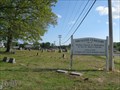 view gallery view gallerySW3.1 km |  Ebenezer Cemetery - Great Mills MD Ebenezer Cemetery - Great Mills MD
in Churchyard Cemeteries The original Ebenezer Church is gone, but the churchyard is still active. posted by: La de Boheme location: Maryland date approved: 05/31/2012 last visited: never |
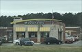 view gallery view galleryW3.1 km |  McDonald's - Route 235 - California, MD McDonald's - Route 235 - California, MD
in McDonald's Restaurants A McDonald's in California, Maryland. posted by: bluesnote location: Maryland date approved: 12/20/2021 last visited: never |
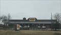 view gallery view galleryW3.1 km |  Cracker Barrel - Route 235 - California, MD Cracker Barrel - Route 235 - California, MD
in Cracker Barrel Restaurants A Cracker Barrel in California, Maryland. posted by: bluesnote location: Maryland date approved: 12/19/2021 last visited: never |
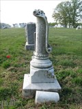 view gallery view gallerySW3.1 km |  Milburn - Ebenezer Cemetery - Great Mills, MD Milburn - Ebenezer Cemetery - Great Mills, MD
in Broken Column Headstones A small broken column adorned with roses and a banner stands in memory of a baby daughter. posted by: La de Boheme location: Maryland date approved: 05/30/2012 last visited: never |
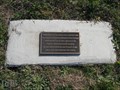 view gallery view gallerySW3.1 km |  Remains Of A Unknown Male - Great Mills MD USA Remains Of A Unknown Male - Great Mills MD USA
in Graves of the Unknown An unmarked grave from the late 1800s was inadvertantly uncovered and the unknown man was reburied after analysis and research failed to reveal his identity. posted by: La de Boheme location: Maryland date approved: 05/30/2012 last visited: never |
 view gallery view galleryW3.1 km |  Panera Break - Route 235 - California, MD Panera Break - Route 235 - California, MD
in Panera Bread Restaurants A Panera in California, Maryland. posted by: bluesnote location: Maryland date approved: 12/22/2021 last visited: never |
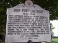 view gallery view galleryN3.1 km | Drum Point Lighthouse Historic Marker in Maryland Historical Markers Another historic marker along Route 2 leading into Solomons Island, Maryland. The marker is outside of the Calvert Marine Museum. Behind the marker a visitor can see the relocated and refurbished Drum Point screwpile lighthouse. posted by: redlights location: Maryland date approved: 05/28/2007 last visited: 11/11/2011 |
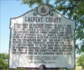 view gallery view galleryN3.1 km | CALVERT COUNTY (no. 2) in Maryland Historical Markers This historical marker is located across from the Visitors Center in Solomons, MD. There is room to park very close by or you can park in the Visitor Center's lot. posted by: redlights location: Maryland date approved: 07/11/2008 last visited: 08/21/2021 |
 view gallery view gallery S3.2 km S3.2 km
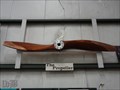
|  The Propeller - Lexington Park MD The Propeller - Lexington Park MD
in Ship Screws and Aircraft Props An experimental flying boat propeller is on display at the Patuxent River Naval Air Museum. posted by: La de Boheme location: Maryland date approved: 04/26/2012 last visited: never |
|