 view gallery view gallery NW5.3 km NW5.3 km
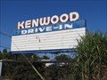
|   Kenwood Drive-in - Louisville, KY Kenwood Drive-in - Louisville, KY
in Closed Drive-In Theatres The Kenwood Drive-in was a single screen theater with a capacity for up to 800 cars. The
audio was provided with FM (87.9) local radio broadcast. posted by:  DougK DougK location: Kentucky date approved: 10/19/2011 last visited: never |
 view gallery view gallery SW6 km SW6 km
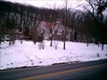
|  JCMF Welcome Center JCMF Welcome Center
in Nature Centers Located in Jefferson County Memorial Forest. posted by:  emurock emurock location: Kentucky date approved: 02/16/2008 last visited: 08/16/2009 |
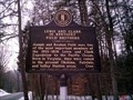 view gallery view gallerySW6 km |  Field Brothers Field Brothers
in Kentucky Historical Markers This waymark is at the beginning of the siltstone trail in Jefferson County Memorial Forest. You can park at the welcome center which is just across the road from the waymark.
posted by: emurock location: Kentucky date approved: 03/10/2008 last visited: 08/16/2009 |
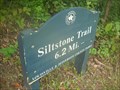 view gallery view gallerySW6 km |  Siltstone Trail, Jefferson Memorial Forest, Kentucky Siltstone Trail, Jefferson Memorial Forest, Kentucky
in Hiking and walking trailheads The Siltstone Trail is 6.2 miles of walking along a ridgeline in the Jefferson Memorial Forest. posted by: Saureus location: Kentucky date approved: 10/10/2009 last visited: never |
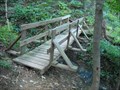
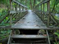 view gallery view gallerySW6.1 km |  First Bridge on the Siltstone Trail, Jefferson Memorial Forest, Kentucky First Bridge on the Siltstone Trail, Jefferson Memorial Forest, Kentucky
in Hiking Path Footbridges There are several footbridges along the challenging Siltstone Trail. This is the easiest one to find. posted by: Saureus location: Kentucky date approved: 10/10/2009 last visited: never |
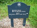 view gallery view gallerySW6.3 km | Red and Mitchell Hill Lake Trails, Jefferson Memorial Forest, Kentucky in Hiking and walking trailheads From this trailhead one can take hikes of varying lengths through the woods of central Kentucky, perhaps stopping by Mitchell Hill Lake or an old family cemetery. posted by: Saureus location: Kentucky date approved: 09/20/2009 last visited: never |
 view gallery view gallery S6.9 km S6.9 km
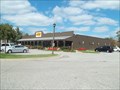
|  Cracker Barrel - I-65 Exit 121 - Shepherdsville, KY Cracker Barrel - I-65 Exit 121 - Shepherdsville, KY
in Cracker Barrel Restaurants Cracker Barrel I-65 Exit 121 - Shepherdsville, KY 40165 posted by: walkingwildly location: Kentucky date approved: 09/14/2014 last visited: 05/28/2018 |
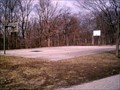 view gallery view galleryNW6.9 km |  Upper Iroquois Basketball Court Upper Iroquois Basketball Court
in Outdoor Basketball Courts A full Basketball count at the top of Iroquois hill. posted by: emurock location: Kentucky date approved: 02/19/2008 last visited: 07/19/2009 |
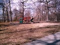 view gallery view galleryNW7.1 km |  Upper Iroquois Playground Upper Iroquois Playground
in Public Playgrounds A playground located at the top of Iroquois hill. posted by: emurock location: Kentucky date approved: 02/18/2008 last visited: 07/19/2009 |
 view gallery view gallerySW7.2 km |  Footbridge on Siltstone Trail, Jefferson Memorial Forest, Kentucky Footbridge on Siltstone Trail, Jefferson Memorial Forest, Kentucky
in Eagle Scout Project Sites This footbridge crossing a gulch running down a hillside in the Jefferson Memorial Forest was created by the hard work of Matt Reardons of Troop 273. posted by: Saureus location: Kentucky date approved: 10/11/2009 last visited: never |
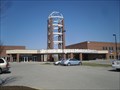 view gallery view galleryS7.2 km |  Jewish Hospital Medical Center South, Shepherdsville, Kentucky Jewish Hospital Medical Center South, Shepherdsville, Kentucky
in Hospitals A large hospital serving the communities of south western Louisville. Opened in May 2006 the facility provides 24 hour care every day of the year to their community. posted by: PersonsMD location: Kentucky date approved: 03/19/2010 last visited: 03/18/2010 |
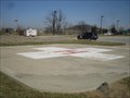 view gallery view galleryS7.2 km |  Jewish Hospital Medical Center South, Louisville, Kentucky Jewish Hospital Medical Center South, Louisville, Kentucky
in Helicopter Landing Pads Located on the property of the Jewish Hospital Medical Center South property this landing pad provides emergency transport and first responder services for the facilities emergency room. posted by: PersonsMD location: Kentucky date approved: 03/19/2010 last visited: 03/18/2010 |
 view gallery view gallery N7.2 km N7.2 km
|  Louisville International Airport (Standiford Field) – Louisville, KY Louisville International Airport (Standiford Field) – Louisville, KY
in Airports airnav.com/airport/KSDF posted by: ChapterhouseInc location: Kentucky date approved: 04/29/2006 last visited: 04/04/2016 |
 view gallery view galleryN7.2 km |  Louisville International Airport (Standiford Field) – Louisville, KY Louisville International Airport (Standiford Field) – Louisville, KY
in Inside Airports Not the largest airport, but it has things to keep you entertained during your time sentenced here. posted by: ChapterhouseInc location: Kentucky date approved: 03/19/2010 last visited: 04/04/2016 |
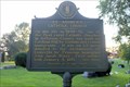
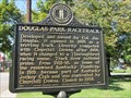 view gallery view galleryNW7.4 km | Douglas Park Racetrack in Kentucky Historical Markers This Kentucky historic Marker is located on South 2nd Street at the NW intersection with Kenwood way in Louisville, Kentucky. The marker was placed in 2010. posted by: DougK location: Kentucky date approved: 10/13/2011 last visited: never |
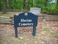 view gallery view gallerySW7.6 km |  Horine Family Cemetery, Jefferson Memorial Forest, Kentucky Horine Family Cemetery, Jefferson Memorial Forest, Kentucky
in Worldwide Cemeteries Be prepared for a nice hike through the woods to find this old family cemetery. posted by: Saureus location: Kentucky date approved: 09/21/2009 last visited: never |
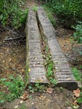 view gallery view gallerySW7.6 km | The Red Trail, Jefferson Memorial Forest, Kentucky in Hiking Path Footbridges Two shaved and graded logs to help hikers over a creek bed at the bottom of a deep valley. posted by: Saureus location: Kentucky date approved: 09/20/2009 last visited: never |
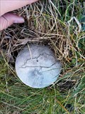
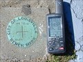 view gallery view galleryNW8 km |  City of Louisville Bench Mark City of Louisville Bench Mark
in U.S. Benchmarks City of Louisville Bench Mark # 20-4. posted by: beachkid location: Kentucky date approved: 03/26/2007 last visited: 11/15/2007 |
 view gallery view galleryN8.2 km | KY R/W - Louisville, KY in U.S. Benchmarks Kentucky Benchmark R/W. posted by: kilroy18 location: Kentucky date approved: 12/23/2016 last visited: never |
 view gallery view galleryN8.5 km |  Six Flags - Kentucky Kingdom Six Flags - Kentucky Kingdom
in Amusement Parks Amusement and Water Park posted by: bdpalace location: Kentucky date approved: 05/18/2007 last visited: 07/07/2008 |
 view gallery view gallery W8.5 km W8.5 km
| St. Andrew's Catholic Church/Early Catholic Church in Kentucky Historical Markers Located on St. Anthony Church Rd. at cemetery -7500 St. Anthony Church Rd posted by: Markerman62 location: Kentucky date approved: 07/23/2017 last visited: 07/09/2017 |
 view gallery view galleryN8.7 km |  Yum! - Louisville, Kentucky Yum! - Louisville, Kentucky
in Publicly Held Corporation Headquarters If you've ever had finger-lickin' good chicken or made a run for the border, then you've enjoyed food from the world's largest restaurant company. posted by: Saureus location: Kentucky date approved: 10/10/2009 last visited: 03/06/2011 |
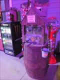 view gallery view galleryN8.7 km |  Louisville Mega Cavern - Louisville, KY Louisville Mega Cavern - Louisville, KY
in Penny Smashers This penny smasher is located at Louisville Mega Cavern 1841 Taylor Ave, Louisville, KY. posted by: DougandSandra location: Kentucky date approved: 03/22/2015 last visited: never |
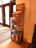 view gallery view galleryN8.7 km | Louisville Slugger Museum and Factory - Louisville, KY in Penny Smashers This penny smasher is located at Louisville Slugger Museum and Factory 800 West Main St. Louisville, KY. posted by: DougandSandra location: Kentucky date approved: 03/22/2015 last visited: 08/31/2022 |
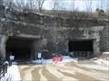 view gallery view galleryN8.7 km | ") Mega Cavern - Louisville, Kentucky Mega Cavern - Louisville, Kentucky
in Cave Entrances (Artificial) The former Louisville Crushed Stone Mine is located at 1841 Taylor Ave., in Louisville. It was created by a massive limestone quarry—with miners blasting out rock starting back in the 1930’s. posted by: DougandSandra location: Kentucky date approved: 03/26/2015 last visited: 06/11/2021 |
|