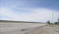
 view gallery view gallery SE9.5 km SE9.5 km
|   Canyon Country - Canyonlands of Utah Canyon Country - Canyonlands of Utah
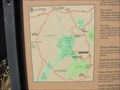
in 'You Are Here' Maps Map of the canyon country at the turn off on Utah 211 heading to Canyonlands National Park. posted by:  linkys linkys location: Utah date approved: 11/11/2009 last visited: 01/08/2016 |
 view gallery view gallery W11.4 km W11.4 km
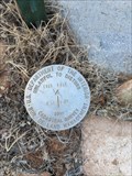
|  T31S R21E 1/4 S14|S13 - San Juan, Co. UT T31S R21E 1/4 S14|S13 - San Juan, Co. UT
in U.S. Benchmarks BLM 2009 Cadastral Survey Marker at T31S R21E 1/4 S14|S13 posted by:  lahontan lahontan location: Utah date approved: 08/18/2022 last visited: never |
 view gallery view gallery SW15.1 km SW15.1 km
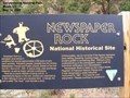
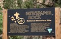
|  Newspaper Rock State Historical Monument - Monticello UT Newspaper Rock State Historical Monument - Monticello UT
in Utah Historical Markers Marker is located in Newspaper Rock State Park on the Utah Route 211, a paved road that leads to the Needles district of Canyonlands National Park, Monticello UT 84535. posted by: Don.Morfe location: Utah date approved: 11/09/2023 last visited: 11/10/2023 |
 view gallery view gallerySW15.1 km |  Newspaper Rock State Historical Monument - Monticello UT Newspaper Rock State Historical Monument - Monticello UT
in Wikipedia Entries Marker is located in Newspaper Rock State Park on the Utah Route 211, a paved road that leads to the Needles district of Canyonlands National Park, Monticello UT 84535. posted by: Don.Morfe location: Utah date approved: 11/09/2023 last visited: 11/10/2023 |
 view gallery view gallerySW15.1 km |  Newspaper Rock State Historical Monument - Monticello UT Newspaper Rock State Historical Monument - Monticello UT
in Official Local Tourism Attractions Marker is located in Newspaper Rock State Park on the Utah Route 211, a paved road that leads to the Needles district of Canyonlands National Park, Monticello UT 84535. posted by: Don.Morfe location: Utah date approved: 11/09/2023 last visited: 11/10/2023 |
 view gallery view gallerySW15.1 km |  Newspaper Rock State Historical Monument - Monticello UT Newspaper Rock State Historical Monument - Monticello UT
in Satellite Imagery Oddities Marker is located in Newspaper Rock State Park on the Utah Route 211, a paved road that leads to the Needles district of Canyonlands National Park, Monticello UT 84535. posted by: Don.Morfe location: Utah date approved: 11/10/2023 last visited: 11/10/2023 |
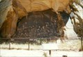
 view gallery view gallerySW15.3 km |  Newspaper Rock - Utah Newspaper Rock - Utah
in Pictographs A wonderful piece of Native-American history, with parts both in Pre-historic and Historic time. Free to see and view. posted by: gparkes location: Utah date approved: 11/17/2008 last visited: 11/09/2023 |
 view gallery view gallerySW15.3 km |  Indian Creek State Park - Montecello, UT Indian Creek State Park - Montecello, UT
in U.S. National Register of Historic Places One of the largest collections of petroglyphs located on a single panel of rock. posted by: gparkes location: Utah date approved: 12/31/2008 last visited: 11/09/2023 |
 view gallery view gallerySW15.3 km |  Newspaper Rock Petroglyphs - Utah Newspaper Rock Petroglyphs - Utah
in New World Ancient Evidence One of the largest collections of petroglyphs located on a single panel of rock. posted by: gparkes location: Utah date approved: 12/30/2008 last visited: 11/09/2023 |
 view gallery view gallery N19 km N19 km
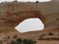
|  Wilson Arch Wilson Arch
in Natural Arches A spectacular arch right next to Highway 191, formerly called Highway 163 according to my old Mapsource Topo maps. posted by: Miragee location: Utah date approved: 06/25/2006 last visited: 10/20/2014 |
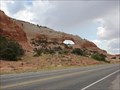 view gallery view galleryN19 km | Wilson arch in Wikipedia Entries Wilson Arch, has a span of 91 feet and height of 46 feet, and is located about 24 miles south of Moab, Utah on US 191. The arch is visible from the road. There is a pulloff on the east with interpretive signs. posted by: JacobBarlow location: Utah date approved: 07/25/2007 last visited: 10/20/2014 |
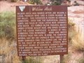 view gallery view galleryN19 km | Wilson Arch - Monticello UT in Utah Historical Markers "Wilson Arch was named after Joe Wilson, a local pioneer who had a cabin nearby in Dry Valley. This formation is known as Entrada Sandstone. Over time superficial cracks, joints, and folds of these layers were saturated with water." posted by: Don.Morfe location: Utah date approved: 08/05/2022 last visited: 10/20/2014 |
 view gallery view gallerySE21.7 km |  Monticello City Airport ~ Monticello, Utah Monticello City Airport ~ Monticello, Utah
in Airports This Airport is located on the west side of US Highway 191, about 3 miles north of Monticello, Utah. There is no visible signage at this airport. posted by: brwhiz location: Utah date approved: 05/18/2013 last visited: never |
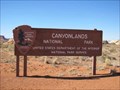 view gallery view galleryW24.8 km | ") Canyonlands NP - Needles District Canyonlands NP - Needles District
in National Parks (U.S.) A sprawling National Park in South Eastern Utah that has three separate districts, but has no roads linking them because of its unbelievable namesake canyons. posted by: linkys location: Utah date approved: 11/11/2009 last visited: 11/18/2021 |
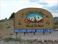
 view gallery view gallery S26.7 km S26.7 km
|  Monticello, Utah ! Monticello, Utah !
in Welcome Signs Monticello, Utah. Home of the Hideout. posted by: JacobBarlow location: Utah date approved: 07/26/2007 last visited: 05/25/2011 |
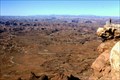 view gallery view gallery NW27.2 km NW27.2 km
|  Needles Overlook, Canyonlands, Utah, USA Needles Overlook, Canyonlands, Utah, USA
in Scenic Overlooks You will find the most spectacular picnictable in the USA posted by: g300td location: Utah date approved: 09/29/2014 last visited: 11/09/2023 |
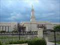 view gallery view galleryS27.7 km |  Monticello Utah Temple Monticello Utah Temple
in Mormon Temples Once the smallest temple of the Church, the temple was expanded an additional 4,000 square feet... posted by: JacobBarlow location: Utah date approved: 08/29/2007 last visited: 09/08/2019 |
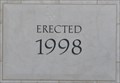 view gallery view galleryS27.7 km |  1998 - LDS Temple ~ Monticello, Utah 1998 - LDS Temple ~ Monticello, Utah
in Dated Buildings and Cornerstones This Cornerstone is embedded in the southeast corner of the LDS Temple located at 365 N 200 West in Monticello, Utah. posted by: brwhiz location: Utah date approved: 05/12/2013 last visited: never |
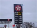 view gallery view galleryS27.7 km |  Monticello Subway Monticello Subway
in Subway Restaurants Subway in the Texaco in Monticello posted by: caverspencer location: Utah date approved: 01/23/2007 last visited: 01/08/2016 |
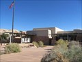 view gallery view galleryW27.8 km |  Canyonlands NP - Needles District Visitors Center Canyonlands NP - Needles District Visitors Center
in Tourist Information Centers - Visitor Centers Visitor Center serving visitors to the Needles District of Canyonlands National Park in southeastern Utah. posted by: linkys location: Utah date approved: 11/10/2009 last visited: 02/16/2020 |
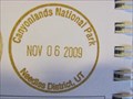 view gallery view galleryW27.8 km |  Canyonlands NP - Needles District Canyonlands NP - Needles District
in NPS Passport Cancellation Stations Passport station for one of the three Districts of this sprawling park in southeastern Utah. posted by: linkys location: Utah date approved: 11/17/2009 last visited: 02/16/2020 |
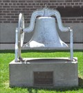 view gallery view galleryS28 km |  Old School Bell ~ 1897 - 1959 Old School Bell ~ 1897 - 1959
in Bells This Bell is mounted on a concrete monument in front of the modern Monticello School building located at 197 N 200 West in Monticello, Utah. posted by: brwhiz location: Utah date approved: 05/15/2013 last visited: never |
 view gallery view galleryS28 km | Monticello, Utah in Wikipedia Entries Monticello is a city in San Juan County, Utah (USA). The population was 1,958 at the 2000 census. It is the county seat of San Juan County posted by: JacobBarlow location: Utah date approved: 12/02/2007 last visited: 05/25/2011 |
 view gallery view gallery NE28.2 km NE28.2 km
| La Sal, Utah 84530 in Wikipedia Entries La Sal is a small community of about 340 inhabitants in the northeast corner of San Juan County. posted by: brwhiz location: Utah date approved: 06/11/2011 last visited: never |
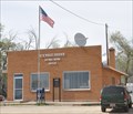
 view gallery view galleryNE28.2 km |  La Sal, Utah 84530 La Sal, Utah 84530
in U.S. Post Offices The small La Sal Post Office serves only about 70 households from its location at 2 Main Street. posted by: brwhiz location: Utah date approved: 06/12/2011 last visited: never |
|