 view gallery view gallery SE3.1 km SE3.1 km
|   Canyon Country - Canyonlands of Utah Canyon Country - Canyonlands of Utah
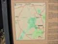
in 'You Are Here' Maps Map of the canyon country at the turn off on Utah 211 heading to Canyonlands National Park. posted by:  linkys linkys location: Utah date approved: 11/11/2009 last visited: 01/08/2016 |
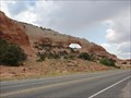
 view gallery view gallery SW16.7 km SW16.7 km
|  Newspaper Rock State Historical Monument - Monticello UT Newspaper Rock State Historical Monument - Monticello UT
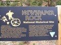
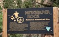
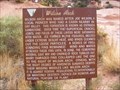
in Official Local Tourism Attractions Marker is located in Newspaper Rock State Park on the Utah Route 211, a paved road that leads to the Needles district of Canyonlands National Park, Monticello UT 84535. posted by: Don.Morfe location: Utah date approved: 11/09/2023 last visited: 11/10/2023 |
 view gallery view gallerySW16.7 km |  Newspaper Rock State Historical Monument - Monticello UT Newspaper Rock State Historical Monument - Monticello UT
in Wikipedia Entries Marker is located in Newspaper Rock State Park on the Utah Route 211, a paved road that leads to the Needles district of Canyonlands National Park, Monticello UT 84535. posted by: Don.Morfe location: Utah date approved: 11/09/2023 last visited: 11/10/2023 |
 view gallery view gallerySW16.7 km |  Newspaper Rock State Historical Monument - Monticello UT Newspaper Rock State Historical Monument - Monticello UT
in Utah Historical Markers Marker is located in Newspaper Rock State Park on the Utah Route 211, a paved road that leads to the Needles district of Canyonlands National Park, Monticello UT 84535. posted by: Don.Morfe location: Utah date approved: 11/09/2023 last visited: 11/10/2023 |
 view gallery view gallerySW16.7 km |  Newspaper Rock State Historical Monument - Monticello UT Newspaper Rock State Historical Monument - Monticello UT
in Satellite Imagery Oddities Marker is located in Newspaper Rock State Park on the Utah Route 211, a paved road that leads to the Needles district of Canyonlands National Park, Monticello UT 84535. posted by: Don.Morfe location: Utah date approved: 11/10/2023 last visited: 11/10/2023 |
 view gallery view gallerySW16.9 km |  Indian Creek State Park - Montecello, UT Indian Creek State Park - Montecello, UT
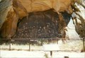
in U.S. National Register of Historic Places One of the largest collections of petroglyphs located on a single panel of rock. posted by: gparkes location: Utah date approved: 12/31/2008 last visited: 11/09/2023 |
 view gallery view gallerySW16.9 km |  Newspaper Rock Petroglyphs - Utah Newspaper Rock Petroglyphs - Utah
in New World Ancient Evidence One of the largest collections of petroglyphs located on a single panel of rock. posted by: gparkes location: Utah date approved: 12/30/2008 last visited: 11/09/2023 |
 view gallery view gallerySW16.9 km |  Newspaper Rock - Utah Newspaper Rock - Utah
in Pictographs A wonderful piece of Native-American history, with parts both in Pre-historic and Historic time. Free to see and view. posted by: gparkes location: Utah date approved: 11/17/2008 last visited: 11/09/2023 |
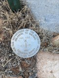 view gallery view gallery W17.1 km W17.1 km
|  T31S R21E 1/4 S14|S13 - San Juan, Co. UT T31S R21E 1/4 S14|S13 - San Juan, Co. UT
in U.S. Benchmarks BLM 2009 Cadastral Survey Marker at T31S R21E 1/4 S14|S13 posted by:  lahontan lahontan location: Utah date approved: 08/18/2022 last visited: never |
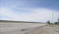 view gallery view gallery S17.7 km S17.7 km
|  Monticello City Airport ~ Monticello, Utah Monticello City Airport ~ Monticello, Utah
in Airports This Airport is located on the west side of US Highway 191, about 3 miles north of Monticello, Utah. There is no visible signage at this airport. posted by: brwhiz location: Utah date approved: 05/18/2013 last visited: never |
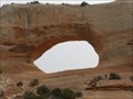 view gallery view gallery N20.1 km N20.1 km
|  Wilson Arch Wilson Arch
in Natural Arches A spectacular arch right next to Highway 191, formerly called Highway 163 according to my old Mapsource Topo maps. posted by: Miragee location: Utah date approved: 06/25/2006 last visited: 10/20/2014 |
 view gallery view galleryN20.1 km | Wilson arch in Wikipedia Entries Wilson Arch, has a span of 91 feet and height of 46 feet, and is located about 24 miles south of Moab, Utah on US 191. The arch is visible from the road. There is a pulloff on the east with interpretive signs. posted by: JacobBarlow location: Utah date approved: 07/25/2007 last visited: 10/20/2014 |
 view gallery view galleryN20.1 km | Wilson Arch - Monticello UT in Utah Historical Markers "Wilson Arch was named after Joe Wilson, a local pioneer who had a cabin nearby in Dry Valley. This formation is known as Entrada Sandstone. Over time superficial cracks, joints, and folds of these layers were saturated with water." posted by: Don.Morfe location: Utah date approved: 08/05/2022 last visited: 10/20/2014 |
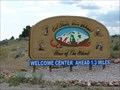
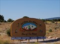
 view gallery view galleryS22.9 km |  Monticello, Utah ! Monticello, Utah !
in Welcome Signs Monticello, Utah. Home of the Hideout. posted by: JacobBarlow location: Utah date approved: 07/26/2007 last visited: 05/25/2011 |
 view gallery view galleryS24 km |  Monticello Subway Monticello Subway
in Subway Restaurants Subway in the Texaco in Monticello posted by: caverspencer location: Utah date approved: 01/23/2007 last visited: 01/08/2016 |
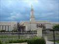 view gallery view galleryS24 km |  Monticello Utah Temple Monticello Utah Temple
in Mormon Temples Once the smallest temple of the Church, the temple was expanded an additional 4,000 square feet... posted by: JacobBarlow location: Utah date approved: 08/29/2007 last visited: 09/08/2019 |
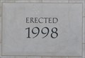 view gallery view galleryS24 km |  1998 - LDS Temple ~ Monticello, Utah 1998 - LDS Temple ~ Monticello, Utah
in Dated Buildings and Cornerstones This Cornerstone is embedded in the southeast corner of the LDS Temple located at 365 N 200 West in Monticello, Utah. posted by: brwhiz location: Utah date approved: 05/12/2013 last visited: never |
 view gallery view galleryS24.3 km | Monticello, Utah in Wikipedia Entries Monticello is a city in San Juan County, Utah (USA). The population was 1,958 at the 2000 census. It is the county seat of San Juan County posted by: JacobBarlow location: Utah date approved: 12/02/2007 last visited: 05/25/2011 |
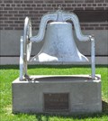 view gallery view galleryS24.3 km |  Old School Bell ~ 1897 - 1959 Old School Bell ~ 1897 - 1959
in Bells This Bell is mounted on a concrete monument in front of the modern Monticello School building located at 197 N 200 West in Monticello, Utah. posted by: brwhiz location: Utah date approved: 05/15/2013 last visited: never |
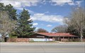 view gallery view galleryS24.5 km |  San Juan County Library ~ Monticello Branch San Juan County Library ~ Monticello Branch
in Libraries This Library is located at 80 N Main Street in Monticello, Utah. posted by: brwhiz location: Utah date approved: 05/12/2013 last visited: never |
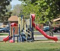 view gallery view galleryS24.6 km |  Veterans Memorial Park Playground Veterans Memorial Park Playground
in Public Playgrounds This Public Playground is located in Veterans Memorial Park at the intersection of US Highway 191 and Utah Highway 491 in Monticello, Utah. posted by: brwhiz location: Utah date approved: 05/13/2013 last visited: never |
 view gallery view galleryS24.6 km |  Monticello - Utah Monticello - Utah
in American Guide Series Heading south on 191, we passed through Monticello, named after Thomas Jefferson's famous Virginia home. posted by: 94RedRover location: Utah date approved: 03/16/2009 last visited: 10/09/2013 |
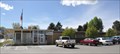 view gallery view galleryS24.6 km |  Monticello, Utah Monticello, Utah
in City and Town Halls This City Hall is located at 17 N 100 East in Monticello, Utah. posted by: brwhiz location: Utah date approved: 05/17/2013 last visited: never |
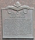 view gallery view galleryS24.8 km |  Monticello ~ 212 Monticello ~ 212
in D.U.P. Historic Markers This Daughters of Utah Pioneers Historical Marker is mounted on a dressed-stone monument at the southwest corner of the San Juan County Administrative Building at 117 S Main Street in Monticello, Utah. posted by: brwhiz location: Utah date approved: 11/17/2012 last visited: never |
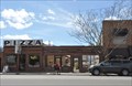 view gallery view galleryS24.8 km |  Wagon Wheel Pizza Wagon Wheel Pizza
in Wagon Wheels These Wagon Wheels form part of the decor for the wall along the front of the outdoor dining area for Wagon Wheel Pizza located at 164 S Main Street in Monticello, Utah. posted by: brwhiz location: Utah date approved: 05/12/2013 last visited: 10/09/2013 |
|