 view gallery view gallery N1.4 km N1.4 km
|   Ozark Caverns - Lake of the Ozarks Missouri State Park Ozark Caverns - Lake of the Ozarks Missouri State Park
in State Park Passport Locations The Ozark Caverns Visitors Center provides a stamping station for Missouri State Park Passports posted by:  cldisme cldisme location: Missouri date approved: 06/26/2011 last visited: never |
 view gallery view gallery SE2.9 km SE2.9 km
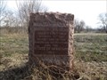
|  Boone's Lick Road - Head's Fort - 1812 Boone's Lick Road - Head's Fort - 1812
in Missouri Historical Markers A granite monument placed by the Daughters of the American Revolution marking an important stop along the Boone's Lick Road. posted by: Utapao72 location: Missouri date approved: 12/10/2015 last visited: never |
 view gallery view gallery NE7.1 km NE7.1 km
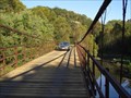
|  Grand Auglaize Swinging Bridge Grand Auglaize Swinging Bridge
in Suspension Bridges This is the longest of five swinging bridges located near lake of the Ozarks at Camdenton, MO. posted by: RGS location: Missouri date approved: 12/22/2006 last visited: 03/16/2022 |
 view gallery view gallery NW11.7 km NW11.7 km
|  PICKLED PETE'S - Neon PICKLED PETE'S - Neon
in Neon Signs Pickled Pete's Neon sign Lake of the Ozarks, Missouri posted by:  GEO*Trailblazer 1 GEO*Trailblazer 1 location: Missouri date approved: 04/07/2008 last visited: 03/20/2014 |
 view gallery view galleryN12.7 km | VISTA GRANDE MEXICAN FOOD - Neon in Neon Signs Vista Grande Mexican Food neon Lake of the Ozarks, Missouri posted by: GEO*Trailblazer 1 location: Missouri date approved: 04/07/2008 last visited: 03/20/2014 |
 view gallery view gallery W14 km W14 km
|  Camden County Courthouse - Camdenton, Missouri Camden County Courthouse - Camdenton, Missouri
in Courthouses The Camden County Courthouse is a two story brick building with the justice center added on to the west side. posted by: Woobie491 location: Missouri date approved: 08/21/2019 last visited: 03/21/2015 |
 view gallery view galleryN14.3 km |  KRMS-FM 93.3, K254BE (KRMS-FM) 98.7, K227DJ (KRMS-AM) 103.3, K285ER (KRMS-FM) 104.9 - Osage Lake MO USA KRMS-FM 93.3, K254BE (KRMS-FM) 98.7, K227DJ (KRMS-AM) 103.3, K285ER (KRMS-FM) 104.9 - Osage Lake MO USA
in Radio and Television Transmitter Towers This FM radio broadcast tower posts hosts three low-power FM repeaters and one FM broadcast antenna for KRMS-AM and KRMS-FM 93.5 along the US 54 at Osage Beach, Missouri posted by: Benchmark Blasterz location: Missouri date approved: 03/23/2023 last visited: 03/25/2023 |
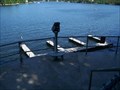
 view gallery view galleryN16.4 km |  Elevated Boats Lake Ozark, MO Elevated Boats Lake Ozark, MO
in Elevated Everyday Objects TWO elevated boats at Lake Ozark, MO. within in one mile of each other. posted by: BrrrMo location: Missouri date approved: 03/05/2009 last visited: 09/19/2013 |
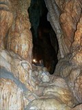
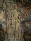
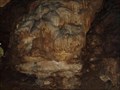 view gallery view galleryW16.7 km | ") River Cave River Cave
in Cave Entrances (Natural) Cave w/beautiful formations located in Ha Ha Tonka State Park, near the Lake of the Ozarks posted by: mlf920 location: Missouri date approved: 04/27/2007 last visited: 04/12/2014 |
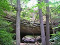 view gallery view gallery SW16.7 km SW16.7 km
| Natural Bridge on Trail-- Ha Ha Tonka State Park in Natural Arches Ha Ha Tonka State Park is noted for its complex of geologic formations—one of which is a natural bridge on a foot trail that descends from one of the park’s upper parking lots before rising again to view the big bluffs and a castle's ruins. posted by: Carpe Diem59 location: Missouri date approved: 07/26/2009 last visited: 10/24/2020 |
 view gallery view galleryW16.7 km |  Hwys D & Y - Camdenton, MO Hwys D & Y - Camdenton, MO
in Blue Star Memorial Highway Markers This Blue Star marker is in front of the Visitor Center at Ha Ha Tonka State park. posted by: iconions location: Missouri date approved: 09/07/2009 last visited: 04/12/2014 |
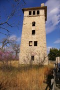 view gallery view gallerySW16.9 km |  Snyder Castle Water Tower - Ha Ha Tonka State Park MO Snyder Castle Water Tower - Ha Ha Tonka State Park MO
in Water Towers Snyder Castle Water Tower - Ha Ha Tonka State Park Camdenton Missouri. posted by: kJfishman location: Missouri date approved: 03/25/2012 last visited: 10/04/2011 |
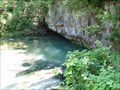 view gallery view gallerySW17.1 km |  Ha Ha Tonka Spring Ha Ha Tonka Spring
in Natural Springs Ha Ha Tonka Springs are Missouri State's 12th largest spring. posted by: Queens Blessing location: Missouri date approved: 11/08/2008 last visited: 10/24/2020 |
 view gallery view gallerySW17.1 km |  Camdenton, Missouri {Ha Ha Tonka State Park}-{Retired Location} Camdenton, Missouri {Ha Ha Tonka State Park}-{Retired Location}
in U.S. Post Offices Ha Ha Tonka Post Office posted by: kJfishman location: Missouri date approved: 03/25/2012 last visited: 04/12/2014 |
 SW17.2 km |  Ha Ha Tonka Castle Ha Ha Tonka Castle
in Castles The Ha Ha Tonka "castle" in Ha Ha Tonka State Park is actually the ruins of the Snyder family mansion that burned in 1942. posted by: MadDogAnger location: Missouri date approved: 05/31/2006 last visited: 07/08/2014 |
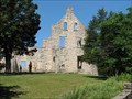 view gallery view gallerySW17.2 km |  Ha Ha Tonka State Park - Camdenton, MO Ha Ha Tonka State Park - Camdenton, MO
in State/Provincial Parks This is a wonderful State Park near Camdenton, MO that features the ruins of a stone castle. posted by: Queens Blessing location: Missouri date approved: 11/05/2008 last visited: 07/08/2014 |
 view gallery view gallerySW17.2 km |  Jim Kirk Jim Kirk
in Dedicated Benches Jim Kirk - Ha HA Tonka State Park posted by: kJfishman location: Missouri date approved: 03/26/2012 last visited: 03/26/2012 |
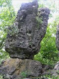 view gallery view gallerySW17.4 km |  Balanced Rock on Trail -- Ha Ha Tonka State Park Balanced Rock on Trail -- Ha Ha Tonka State Park
in Nature's Balanced Rocks A balanced rock sits high above the Lake of the Ozarks on an island in Ha Ha Tonka State Park. The Island trail starts in a parking lot at lake level. A castle's ruins are on a high bluff some 200 feet above the lake. posted by: Carpe Diem59 location: Missouri date approved: 07/30/2009 last visited: 06/17/2011 |
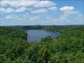 view gallery view galleryW17.4 km |  Thunder Mountain - Camdenton, MO Thunder Mountain - Camdenton, MO
in Scenic Roadside Look-Outs Great view of the Lake of the Ozarks posted by: Team Farkle 7 location: Missouri date approved: 07/18/2007 last visited: 04/19/2014 |
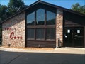
 view gallery view galleryW17.7 km | Bridal Cave - Camdenton, MO in State Park Passport Locations Bridal Cave was discovered centuries ago by the Osage Indians beneath Thunder Mountain. It is part of the Missouri Caves Association- "Your Passport to Underground Adventure in Missouri and Arkansas" posted by: Team Farkle 7 location: Missouri date approved: 04/19/2009 last visited: 12/24/2022 |
 view gallery view galleryW17.7 km | Bridal Cave - Camdenton, MO in Cave Entrances (Natural) Centuries ago the Osage Indians discovered the pristine beauty that lies beneath Thunder Mountain. Local folklore tells of a legendary Indian wedding ceremony held in the cave in the early 1800s. posted by: Team Farkle 7 location: Missouri date approved: 08/23/2007 last visited: 04/12/2014 |
 view gallery view galleryW17.7 km |  Lake of the Ozarks at Bridal Cave, Camdenton, MO Lake of the Ozarks at Bridal Cave, Camdenton, MO
in Coin-Op Binoculars Overlooking Lake of the Ozarks posted by: Team Farkle 7 location: Missouri date approved: 08/23/2007 last visited: 04/12/2014 |
 view gallery view galleryW17.7 km |  Bridal Cave - Camdenton, MO Bridal Cave - Camdenton, MO
in Wikipedia Entries Centuries ago the Osage Indians discovered the pristine beauty that lies beneath Thunder Mountain. Local folklore tells of a legendary Indian wedding ceremony held in the cave in the early 1800s. posted by: Team Farkle 7 location: Missouri date approved: 10/06/2009 last visited: 12/24/2022 |
 view gallery view galleryW17.7 km |  Bridal Cave Penny Smasher Bridal Cave Penny Smasher
in Penny Smashers Penny Smasher located at Bridal Cave in Camdenton, MO posted by: Gredgeman location: Missouri date approved: 09/08/2009 last visited: 04/12/2014 |
 view gallery view galleryN18.5 km |  Bagnell Dam Strip Indian Chief Bagnell Dam Strip Indian Chief
in Highway Giants - Muffler Men Indian Chief waving at the crazy looking guy across the road. On the Bagnell Dam Strip at Lake of the Ozarks. posted by: fishallnight location: Missouri date approved: 03/11/2008 last visited: 09/16/2013 |
|