 view gallery view gallery SE8.9 km SE8.9 km
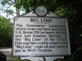
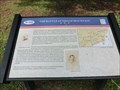
|   Big Lime Big Lime
in West Virginia Historical Markers Greenbrier limestone in the area posted by:  dukemartin dukemartin location: West Virginia date approved: 08/01/2011 last visited: 09/30/2011 |
 view gallery view gallery E9.7 km E9.7 km
|  Renick, WV, 24966, Post Office Renick, WV, 24966, Post Office
in U.S. Post Offices Renick, West Virginia, 24966, Post Office posted by: dukemartin location: West Virginia date approved: 05/08/2012 last visited: never |
 view gallery view galleryE10.1 km |  Greenbrier River Trail, WV - Falling Spring Access Greenbrier River Trail, WV - Falling Spring Access
in Rails to Trails 79 mile long rail trail along side the beautiful Greenbrier River. posted by:  garmin_geek garmin_geek location: West Virginia date approved: 01/21/2009 last visited: 10/25/2008 |
 view gallery view gallerySE12.6 km | Frankford, WV, 24938 in U.S. Post Offices Frankford, West Virginia, 24938, Post Office posted by: dukemartin location: West Virginia date approved: 05/09/2012 last visited: never |
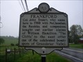 view gallery view gallerySE12.7 km | Frankford in West Virginia Historical Markers A sign telling us who settled here in 1769. posted by: Paintedwarrior location: West Virginia date approved: 05/14/2014 last visited: 08/05/2014 |
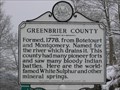 view gallery view galleryE16.3 km | Greenbrier County / Pocahontas County in West Virginia Historical Markers This historic marker is located on US-219 marking the boundary between Greenbrier County and Pocahontas County. Please be careful when visiting this marker, no parking area, just a shoulder and cars do come flying down the road. posted by: Hawaiian Ninja location: West Virginia date approved: 03/20/2009 last visited: 05/11/2013 |
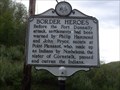 view gallery view gallery S16.4 km S16.4 km
| Border Heroes / Fort Donnally in West Virginia Historical Markers A two sided sign telling us about Fort Donnally and the attacks upon it. posted by: Paintedwarrior location: West Virginia date approved: 05/19/2014 last visited: 05/20/2014 |
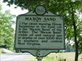 view gallery view galleryE16.6 km | Maxon Sand in West Virginia Historical Markers This historic marker stands on Route 219 in Pocohontas County posted by: Sneakin Deacon location: West Virginia date approved: 11/08/2009 last visited: 07/30/2011 |
 view gallery view galleryE16.9 km |  Droop Mountain Tunnel - Greenbrier River Trail, WV Droop Mountain Tunnel - Greenbrier River Trail, WV
in Abandoned Train Tunnels Droop Mountain Tunnel on the Greenbrier River Trail, MilePost MP-30.9 posted by: garmin_geek location: West Virginia date approved: 01/22/2009 last visited: 05/26/2015 |
 view gallery view galleryS17.7 km | Andrew & Charles Lewis March in West Virginia Historical Markers A sign telling us about a march of the American Colonial army and the out come of the battle at Point Pleasant. posted by: Paintedwarrior location: West Virginia date approved: 05/19/2014 last visited: 05/20/2014 |
 view gallery view galleryS17.7 km | Border Heros in West Virginia Historical Markers This historic marker stand at the intersection of Route 60 and Old State Rt. 12 in Greenbrier County. posted by: Sneakin Deacon location: West Virginia date approved: 11/28/2011 last visited: never |
 view gallery view galleryS17.9 km | Maxwelton, WV, 24957 in U.S. Post Offices Maxwelton, West Virginia, 24957, Post Office posted by: dukemartin location: West Virginia date approved: 05/09/2012 last visited: never |
 view gallery view gallery SW18.5 km SW18.5 km
| Crawley, WV, 24931, Post Office in U.S. Post Offices Crawley, West Virginia, 24931, Post Office posted by: dukemartin location: West Virginia date approved: 05/08/2012 last visited: never |
 view gallery view gallery W19 km W19 km
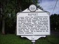
| Rupert in West Virginia Historical Markers Tells you how the town of Rupert was established. posted by: Paintedwarrior location: West Virginia date approved: 05/11/2012 last visited: 07/08/2013 |
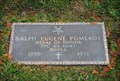 view gallery view gallerySW19.2 km |  Ralph Eugene Pomeroy - Smoot, WV Ralph Eugene Pomeroy - Smoot, WV
in Medal Of Honor Resting Places Ralph E.Pomeroy was awarded the Medal of Honor for his actions during the Korean War. posted by: Sneakin Deacon location: West Virginia date approved: 11/28/2011 last visited: never |
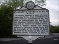
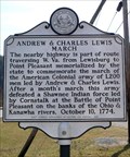 view gallery view galleryS19.2 km | Andrew & Charles Lewis March in West Virginia Historical Markers Marker commemorating the route of Lewis' army to the Battle of Point Pleasant. posted by: SportsPhotoGuy location: West Virginia date approved: 02/20/2009 last visited: 11/09/2011 |
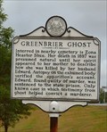 view gallery view gallerySW19.3 km | Greenbrier Ghost in West Virginia Historical Markers Greenbrier Ghost, near Sam Black Church posted by: two-bit Joe location: West Virginia date approved: 08/28/2006 last visited: 05/10/2014 |
 view gallery view gallerySW19.3 km |  Greenbrier Ghost Greenbrier Ghost
in Weird Story Locations Greenbrier Ghost Greenbrier County, WV posted by: two-bit Joe location: West Virginia date approved: 01/23/2006 last visited: 05/10/2014 |
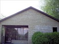
 view gallery view gallerySW19.5 km |  Sam Black Church - Smoot, WV Sam Black Church - Smoot, WV
in U.S. National Register of Historic Places The historic Sam Black Church stands on Route 60 near the Intersection of Interstate 64. posted by: Sneakin Deacon location: West Virginia date approved: 11/28/2011 last visited: never |
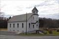 view gallery view gallerySW19.5 km |  Sam Black Church - Smoot, WV Sam Black Church - Smoot, WV
in Country Churches Sam Black Church is located on U. S. Route 60 in the unincorporated community of Smoot, West Virginia posted by: Sneakin Deacon location: West Virginia date approved: 11/29/2011 last visited: never |
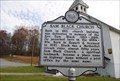 view gallery view gallerySW19.5 km | Sam Black Church in West Virginia Historical Markers This historic marker stands in front of the Sam Black United Methodist Church near Smoot, West Virginia posted by: Sneakin Deacon location: West Virginia date approved: 11/28/2011 last visited: 05/10/2014 |
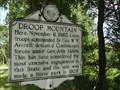 view gallery view gallery NE20.3 km NE20.3 km
| Droop Mountain in West Virginia Historical Markers This historic marker commemorates the Civil War Battle that took place near here. posted by: Sneakin Deacon location: West Virginia date approved: 07/26/2009 last visited: 09/30/2011 |
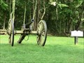 view gallery view galleryNE20.3 km |  10 Lb. Parrott Rifle - Hillsboro WV 10 Lb. Parrott Rifle - Hillsboro WV
in Static Artillery Displays 10 LB. Parrott Rifle-Artillery pieces similar to this reproduction were used by the Confederate army during the Battle of Droop Mountain. posted by: Don.Morfe location: West Virginia date approved: 08/19/2020 last visited: 10/29/2021 |
 view gallery view galleryW20.3 km | Rupert, WV 25984 in U.S. Post Offices Ruoert, WV 25984. Founded by and named for Dr. Cyrus A. Rupert (1812-1891). Pop 940. posted by: SportsPhotoGuy location: West Virginia date approved: 05/30/2010 last visited: 05/06/2012 |
 view gallery view galleryNE20.4 km |  The Battle At Droop Mountain November 6, 1863 - Hillsboro WV The Battle At Droop Mountain November 6, 1863 - Hillsboro WV
in U.S. Civil War Sites Marker is near Hillsboro, West Virginia, in Pocahontas County. Marker can be reached from Seneca Trail (U.S. 219) near George Hill Road (County Route 24/1). This marker is located along the Park Road in Droop Mountain Battlefield State Park. posted by: Don.Morfe location: West Virginia date approved: 07/07/2023 last visited: 07/07/2023 |
|