 view gallery view gallery S1.1 km S1.1 km
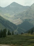
|   Hurricane Pass, CO (12,730 ft.) Hurricane Pass, CO (12,730 ft.)
in Elevation Signs Hurricane Pass is located in the San Juan Mountains of Colorado. posted by:  mr.volkswagen mr.volkswagen location: Colorado date approved: 08/06/2018 last visited: 08/06/2018 |
 view gallery view gallery W5 km W5 km
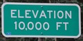
| Million Dollar Highway ~ Elevation 10,000 Feet in Elevation Signs This Elevation Sign is located on the northwest side of the Million Dollar Highway (US Highway 550) about 8.7 miles south of Ouray, Colorado. posted by: brwhiz location: Colorado date approved: 02/15/2013 last visited: 09/14/2014 |
 view gallery view gallery E5.8 km E5.8 km
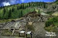
|  San Juan Skyway - Animas Forks, CO San Juan Skyway - Animas Forks, CO
in National Scenic Byways Day two, stop two of the San Juan Skyway Must See Scenic Byway are the ghost towns outside of Silverton, Colorado. posted by:  94RedRover 94RedRover location: Colorado date approved: 01/31/2009 last visited: 10/03/2021 |
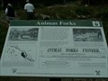 view gallery view galleryE5.8 km |  Animas Forks, Colorado Animas Forks, Colorado
in Signs of History "Three Forks of the Animus" as it was once called, was a prosperous mining town, is now a ghost town visited by 100,000 visitors a year. posted by: 94RedRover location: Colorado date approved: 01/31/2009 last visited: 10/03/2021 |
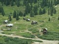 view gallery view galleryE5.8 km |  Animas Forks, Colorado Animas Forks, Colorado
in Wikipedia Entries "Three Forks of the Animus" as it was once called, was a prosperous mining town, is now a ghost town visited by 100,000 visitors a year. posted by: 94RedRover location: Colorado date approved: 01/31/2009 last visited: 10/03/2021 |
 view gallery view galleryE5.8 km |  Animas Forks, Colorado Animas Forks, Colorado
in Ghost Towns "Three Forks of the Animus" as it was once called, was a prosperous mining town, is now a ghost town visited by 100,000 visitors a year. posted by: 94RedRover location: Colorado date approved: 02/01/2009 last visited: 10/03/2021 |
 view gallery view galleryW6.6 km | Idarado Mine - Ouray County - Colorado in Wikipedia Entries The Idarado Mine was a mining operation in the San Juan Mountains posted by: gemeloj location: Colorado date approved: 12/20/2019 last visited: never |
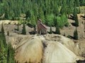 view gallery view galleryW6.6 km |  Idarado Mine mysteries - Ouray county - Colorado Idarado Mine mysteries - Ouray county - Colorado
in News Article Locations Idarado Mine mysteries; Saturday open house to highlight history posted by: gemeloj location: Colorado date approved: 12/20/2019 last visited: never |
 view gallery view galleryW6.6 km |  The Idarado Mine - Ouray county, Colorado The Idarado Mine - Ouray county, Colorado
in Mines The Idarado Mine is a lead mine located in Ouray county, Colorado at an elevation of 10,499 feet. posted by: gemeloj location: Colorado date approved: 12/20/2019 last visited: never |
 view gallery view gallery SW8 km SW8 km
| Red Mountain Pass ~ Elevation 11,018 Feet in Elevation Signs This Elevation Sign is at the summit of Red Mountain Pass on US Highway 550 between Ouray and Silverton, Colorado. posted by: brwhiz location: Colorado date approved: 04/27/2013 last visited: 09/01/2019 |
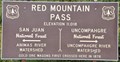 view gallery view gallerySW8 km | Red Mountain Pass ~ Elevation 11,018 Feet in Elevation Signs This Elevation Sign is at the summit of Red Mountain Pass on US Highway 550 between Ouray and Silverton, Colorado. posted by: brwhiz location: Colorado date approved: 04/27/2013 last visited: 07/14/2015 |
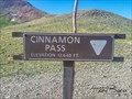 view gallery view galleryE8 km | Cinnamon Pass, CO (12,640 ft.) in Elevation Signs Cinnamon Pass is located in the San Juan Mountians. posted by: mr.volkswagen location: Colorado date approved: 08/06/2018 last visited: 08/06/2018 |
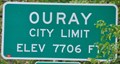 view gallery view gallery N10.1 km N10.1 km
| Ouray, Colorado (Southern Approach) ~ Elevation 7706 Feet in Elevation Signs This Elevation Sign is located on the south side of US Highway 550 at the southern town limit of Ouray, Colorado. posted by: brwhiz location: Colorado date approved: 02/15/2013 last visited: never |
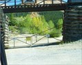
 view gallery view galleryN10.3 km |  Switzerland of America Lookout Point Switzerland of America Lookout Point
in Scenic Roadside Look-Outs This Scenic Roadside Look-Out is on US Highway 550 overlooking Ouray, Colorado as the highway winds it way up out of the canyon to the south of town. posted by: brwhiz location: Colorado date approved: 02/14/2013 last visited: 05/12/2023 |
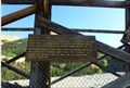
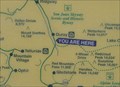 view gallery view galleryN10.3 km |  Ouray Overlook Ouray Overlook
in 'You Are Here' Maps You Are Here at an overlook on the San Juan Skyway Scenic and Historic Byway high above the twon of Ouray. posted by: brwhiz location: Colorado date approved: 09/12/2013 last visited: 05/12/2023 |
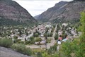 view gallery view galleryN10.3 km |  Ouray from US Highway 550 Ouray from US Highway 550
in Cityscapes This view of historic Ouray, Colorado is from US Highway 550 as it climbs out of the canyon south of town. posted by: brwhiz location: Colorado date approved: 04/02/2013 last visited: 05/12/2023 |
 view gallery view galleryN10.3 km |  Alpine Loop, Ouray, CO Alpine Loop, Ouray, CO
in Offroad Trails Too bad I'm afraid of heights. I didn't get the "Best Shots" cause I was too scared to let go! posted by: 94RedRover location: Colorado date approved: 03/05/2008 last visited: 09/01/2014 |
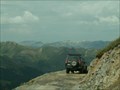
 view gallery view gallery SE10.5 km SE10.5 km
|  International Scout - San Juan County, CO International Scout - San Juan County, CO
in Abandoned Dead Vehicles Located in San Juan County just off of Animas Forks Rd. posted by: mr.volkswagen location: Colorado date approved: 08/04/2015 last visited: never |
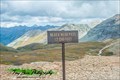 view gallery view galleryW10.5 km | Black Bear Pass, CO (12, 840 ft.) in Elevation Signs Black Bear Pass is located in the San Juan Mountains of Colorado. posted by: mr.volkswagen location: Colorado date approved: 08/06/2018 last visited: 08/06/2018 |
 view gallery view gallery NE10.6 km NE10.6 km
|  Empire Chief Mine and Mill - Lake City, CO Empire Chief Mine and Mill - Lake City, CO
in U.S. National Register of Historic Places Empire Chief Mine and Mill is along the Alpine Loop Byway. You will drive right by the site as you are going towards Lake City or towards Engineer Pass. Site is right next to the road. posted by: mr.volkswagen location: Colorado date approved: 09/08/2014 last visited: 09/08/2014 |
 view gallery view galleryNE10.6 km | Bonanza Empire Chief Mine - Hinsdale County, CO in Mines The Bonanza Empire Chief Mine is located on the Alpine Loop Trail. posted by: mr.volkswagen location: Colorado date approved: 09/14/2014 last visited: never |
 view gallery view gallery NW10.6 km NW10.6 km
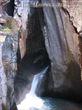
|  Box Canyon Falls - Ouray, CO Box Canyon Falls - Ouray, CO
in Waterfalls Box Canyon is home to Box Canyon Falls, a 285-foot waterfall, with quartzite walls that extend almost one hundred feet past the falls. posted by: ArmyFamily4 location: Colorado date approved: 04/07/2011 last visited: 08/29/2008 |
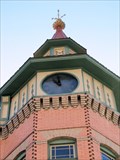 view gallery view galleryN10.6 km |  Elk Lodge #492 - Ouray, CO Elk Lodge #492 - Ouray, CO
in Town Clocks Clock in the tower of the 1904 Elk Lodge in Ouray, CO posted by: Outspoken1 location: Colorado date approved: 07/13/2010 last visited: 09/14/2014 |
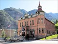 view gallery view galleryN10.6 km |  Elk Lodge #492 - Ouray, CO Elk Lodge #492 - Ouray, CO
in Elks Lodges Elks Lodge of Ouray, CO, built in 1904 posted by: Outspoken1 location: Colorado date approved: 07/12/2010 last visited: 09/04/2016 |
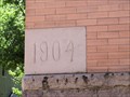 view gallery view galleryN10.6 km |  1904 - Elks Lodge #492 - Ouray, CO 1904 - Elks Lodge #492 - Ouray, CO
in Dated Buildings and Cornerstones 1904 Elk Lodge in historic Ouray, CO posted by: Outspoken1 location: Colorado date approved: 07/12/2010 last visited: 09/14/2014 |
|